Venezuela’s doublet leaned toward Caracas
Two earthquakes greater than magnitude 7 and less than a minute apart broke the same right-lateral fault west of the capital. The physics of how they ruptured concentrated stress in …
Temblor Articles
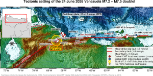
Two earthquakes greater than magnitude 7 and less than a minute apart broke the same right-lateral fault west of the capital. The physics of how they ruptured concentrated stress in …
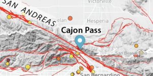
A new paper suggests that at Cajon Pass, the stress is higher than at any time in the past thousand years. Is this finding obvious or alarming? By Ross …
The Cotabato Trench, and perhaps the southernmost Mindanao Fault, may be closer to failure as a result of the magnitude 7.8 mainshock. By Ross Stein, Temblor, Inc. and Shinji …

A tribute to an earthquake scientist of uncommon insight, lucidity, and independence By Ross S. Stein, Temblor, Inc. Between 1984 and 1996, British geophysicist Geoff King and I …
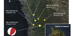
A major earthquake that struck on May 22, 2026, caused multiple rockslides, damage to homes and power outages. The earthquake was the largest on the Big Island since a magnitude …
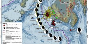
DOST-PHIVOLCS scientists explore recent earthquake swarms off the shores of Mindanao, a southern Philippine island, and consider similarities to the devastating 1976 Moro Gulf earthquake. By Deo Carlo E. …

A 30-year-old assessment warns that a major Tokyo earthquake could crash global financial markets. Whether this holds comes down to key decisions made under pressure, according to a 2022 report. …

Bent railroad tracks and a hidden fault may provide clues to an enduring mystery about the 1886 Charleston earthquake. But not everyone agrees. By Rebecca Owen, science writer (@beccapox/@beccapox.bsky.social) …
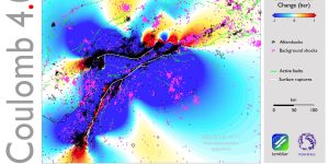
Coulomb 4.0 is open source MATLAB software designed for interactive exploration and visualization of earthquake and volcanic processes. The software can easily incorporate ancillary data, it integrates the ISC earthquake …

Despite being deeply seated, a magnitude 7.0 earthquake beneath Taiwan was widely felt. Like other previous strong, deep earthquakes in the region, which caused damage at the surface, this event …
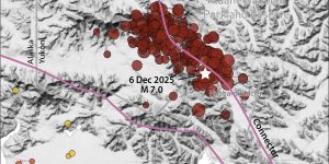
An earthquake that struck a remote part of the Yukon near the Alaska border on December 6, 2025 serves as an example of successful seismic hazard assessment. By Ross …
Tsunami early warning systems offer important information about impending waves. New systems can increase the timeliness and accuracy of warnings. By Rebecca Owen, Science Writer (@beccapox and @beccapox.bsky.social) …
Experts dive into what went well and what needs to be improved when it comes to major earthquakes in Istanbul, Türkiye. By M. Erdik, Boğaziçi University, Istanbul, Türkiye, A. …

Just 10 days after the Kamchatka tsunami hit its shores, the island nation of Samoa received a payout from the Pacific Catastrophe Risk Insurance Company (PCRIC), a regional development insurer. …
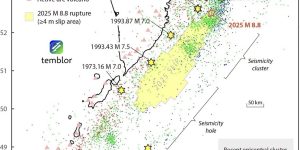
A large foreshock that struck 10 days before the magnitude 8.8 Kamchatka earthquake brought the epicentral megathrust patch closer to failure and produced an exceptionally abundant burst of aftershocks. …

How scientists model slow-slip earthquakes can also help them understand slow-moving landslides, a common hazard along the West Coast. By Rebecca Owen, Science Writer (@beccapox) Citation:Owen, R., 2025, …

Although scientists were not entirely surprised by the magnitude 7.7 earthquake that struck Myanmar on March 28, 2025, the event is a stark reminder that similar active structures exist — …

By Surya Narayan Shrestha (National Society for Earthquake Technology, Kathmandu, Nepal) and Susan E. Hough (U.S. Geological Survey, Pasadena, California. USA) Citation: Narayan Shrestha, S. and Hough, S.E., 2025, …

Minimal damage from the Julian earthquake should result in maximum earthquake preparedness efforts. By Debi Kilb (Scripps Institution of Oceanography at UCSD), Alice-Agnes Gabriel (Scripps Institution of Oceanography at …

The 23 April 2025 earthquake appears to have ruptured a 20-kilometer-long section of the Marmara Fault, near the site of a 2019 magnitude 5.7 shock. Previous major events include earthquakes …

Our short-term forecast suggests that between now and May 1, between 1 and 4 shocks greater than or equal to magnitude 4.0 are expected — fortunately a low rate. Much …

A relatively shallow right-lateral earthquake rocked Myanmar and other parts of southeast Asia, causing damage and death. By Ross S. Stein, Temblor, Inc., and Shinji Toda, Tohoku University …

Much of the world lacks earthquake insurance, but when a magnitude 7.3 earthquake struck Vanuatu, the Pacific island nation was protected. By Ross S. Stein and Gabriel Lotto, Temblor, …

A December 2024 earthquake that occurred off California’s coast highlights concerns surrounding how tsunami risk is communicated. By Rebecca Owen, Science Writer (@beccapox.bsky.social) Citation: Owen, R., 2025, Anatomy …

EarthquakeSim’s YouTube channel has gone viral by exploring how visual storytelling could help disaster preparedness. By Lauren A. Koenig, Ph.D., Science Writer (@Lauren_A_Koenig) Citation: Koenig, L.A., 2025, Simulating …

Catastrophe risk company celebrates a decade of helping the world understand earthquake risk. By Megan Sever, Editor-in-chief, Temblor Earth News On December 17, 2024, a magnitude 7.3 …

Coulomb stress calculations and the distribution of aftershocks indicate that the early December magnitude 7.0 earthquake likely stressed the northern tip of the San Andreas, near the end of the …

El análisis de 14 años de registros sísmicos revela que estos eventos no son estacionales Por Esteban J. Chaves, Observatorio Vulcanológico y Sismológico de Costa Rica, OVSICORI, Universidad Nacional …

Analysis of 14 years of earthquake records reveals that these events aren’t seasonal By Esteban J. Chaves, Ph.D., Volcanological and Seismological Observatory of Costa Rica OVSICORI, Universidad Nacional …

Para aprovechar el valioso tiempo que brindan los sistemas de alerta temprana, los hospitales deben desarrollar protocolos de respuesta ante terremotos meticulosamente elaborados. Por Montana Denton, Temblor science writing …

To take advantage of the valuable time given by early warnings, hospitals must develop meticulous earthquake response protocols. By Montana Denton, Temblor science writing extern (@montana_denton) Citation: Denton, …

A new system for cataloguing earthquake fatalities suggests that five countries have suffered the greatest loss of life over the past 500 years. By Rebecca Owen, Science Writer (@beccapox) …

New research suggests branch faults serve as on-ramps to major fault superhighways. The key to this phenomenon might be that the branch fault ruptures faster than seismic waves can travel …

As we reflect on the fourth anniversary of the 2020 Masbate earthquake, a coconut tree underscores the significance of short recurrence intervals and precise locations of fault ruptures. By …

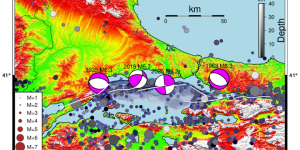
The earthquake that struck offshore eastern Mindanao in the southern Philippines on August 3, 2024 resulted from renewed movement of an extinct fracture zone subducting into Earth’s mantle. That movement …

The largest shocks in the Nankai subduction zone range between magnitude 8 and 9 and occur every 100 to 200 years. But, the recent magnitude 7.1 shock occurred in a …

Information gathered during a 2021 marine research expedition offers insight into the possible behavior of the Pacific Northwest’s most enigmatic fault. By Rebecca Owen, Science Writer (@beccapox) Citation: …

Several studies show that constructing safe structures in earthquake-prone regions can be accomplished using sustainable materials that range from mass timber to recycled tires. By Alice Turner, Simpson Strong-Tie …

The Philippine island of Palawan — considered a stable part of the seismically active country — was recently shaken by two earthquakes in two days, highlighting the need to reassess …

Single-family homes in Los Angeles neighborhoods with predominantly Black, Hispanic, and low-income residents have fewer seismic retrofits than in other parts of the city. By Rebecca Owen, Science Writer …

For the first time in Costa Rica, scientists document that earthquakes can communicate with faults, even at a distance of more than a thousand kilometers. By Sonia Hajaji and …

A memorial to Paul Tapponnier, a scientist at all scales. By Yann Klinger, Institut de Physique du Globe, Université de Paris Cité The first time I physically …

Mga lindol na kasalukuyang nagaganap sa silangang Mindanao, siniyasat ng mga siyentipiko mula sa DOST-PHIVOLCS By Deo Carlo E. Llamas, Jeffrey S. Perez, Crystel Jade M. Legaspi, Jonard Jhon …

DOST-PHIVOLCS scientists explore recent seismicity in eastern Mindanao, a southern Philippine island. By Deo Carlo E. Llamas, Jeffrey S. Perez, Crystel Jade M. Legaspi, Jonard Jhon S. Acid, John …

Simulations of underwater earthquakes and landslides in the Ionian Sea found that they could generate tsunami waves as high as 2.5 meters in southern Italy. By Laura Fattaruso, Simpson …

An earthquake was widely felt across the Los Angeles area. We provide a quick summary of what happened. By Temblor Team Members (@temblor) At 1:49 p.m. local time …

A tribute to Thomas C. Hanks, a USGS geophysicist who showed himself to be a generous mentor, as well as a leading scientist. By Wayne Thatcher, U.S. Geological Survey …

For the AGU 2023 Gutenberg Lecture, Lucile Jones discussed how social science research has helped her to better communicate seismic research to the public and legislators. By Fionna M. …

On April 5, residents across a wide swath of New York, New Jersey, and Pennsylvania experienced what may have been their first — and possibly not last — earthquake. …

A magnitude 7.4 earthquake rocked much of Taiwan, causing death and damage. The eastern side of the island, near the epicenter, was especially affected. By Ross S. Stein, Ph.D., …

Family homes with a room built atop the garage are common across the U.S. In an earthquake, these buildings risk collapse, but they are not currently covered by most local …

After two phases of testing and more than 100 simulated earthquakes, the 10-story TallWood building perched atop the largest shake table in the world remained intact. By Fionna M. …

A new study highlights how predominantly minority neighborhoods in Los Angeles — and especially those with Black populations — will be most affected in the aftermath of a large earthquake. …

Experts reflect on building collapses in the wake of the 2023 Türkiye earthquakes and the importance of earthquake-resilient design in both the U.S. and Türkiye. By Alice Turner, Ph.D., …

A magnitude 7.5 earthquake on the western shores of Honshu, Japan, caused extreme shaking and felled a five-story building on New Year’s Day. The shaking was far more severe than …

After a month of relative quiet, what caused the latest Iceland eruption near Grindavík? Read the latest developments here. By Melissa Scruggs, Ph.D. (@VolcanoDoc) Citation: Scruggs, Melissa A., …

Sa may silangang baybayin ng Isla ng Mindanao sa katimugan ng Pilipinas, malalakas na lindol ang nagmumula bunsod ng labis na aktibidad ng Philippine Trench. Ngunit ang iba’t-ibang fault mechanisms …

Off the eastern shore of Mindanao Island in the southern Philippines, large magnitude earthquakes result from the highly active Philippine Trench. But the varied fault mechanisms of the recent magnitude …

Isang lindol na may lakas na 7.6 na megathrust ang nangyari malapit sa isla ng Mindanao. Matindi ang pagyanig, mayroong maliit na tsunami, at maraming napakalakas na aftershocks ang sumunod. …

A magnitude 7.6 megathrust earthquake occurred near Mindanao Island. Strong shaking, a small tsunami and many very large aftershocks have followed. By Ross S. Stein, Ph.D., Temblor, Inc. and …

Sa nakaraang ilang lingo, dalawang lindol na may Magnitude 6.8 at 7.4 ang tumama sa Mindanao. Ang malakas na pagyanig ay nagdulot ng pagkasira sa mga istruktura, liquefaction, landslides, pagbabago …

Magnitude 6.8 and 7.4 earthquakes struck Mindanao Island in the last couple of weeks. The strong ground shaking caused significant structural damage, liquefaction, landslides, sea-level disturbance and tsunamis. Experts examine …

Creating an international standard for seismic intensity reports will lead to more accurate earthquake characterization. By Montana Denton, Temblor science writing extern (@montana_denton) Citation: Denton, M., 2023, International …

How close is Iceland’s Grindavík to a volcanic eruption? Read the latest developments here. By Melissa Scruggs, Ph.D., Science Writer (@VolcanoDoc) Citation: Scruggs, Melissa A., 2023, Iceland’s ground …

The recent quadruplet of earthquakes that have rocked Herat, Afghanistan, bring an important question to the fore: how can traditional earthen buildings be strengthened to withstand shaking? By Alice …

Immature faults, such as those in the Eastern California Shear Zone, generate widespread fracturing at the surface during earthquakes. A new displacement model characterizes the hazard posed to infrastructure by …

If you’re considering a seismic retrofit, Janiele Maffei, the executive director of the California Residential Mitigation Program, has some advice. By Fionna M. D. Samuels, Ph.D., Optimum Seismic Fellow …

Identifying active fault zones can help scientists determine whether an area is prone to surface rupture; finding features associated with ancient volcanoes may help. By Thystere Matondo Bantidi, Ph.D., …

Meteorological data suggest that simultaneous heavy rainfall from Hurricane Hilary and an earthquake in Ojai, California, were coincidences. By Qiushi Zhai (Caltech Seismological Laboratory, qzhai@caltech.edu), Zhigang Peng (School of …

El devastador terremoto que sacudió Marruecos el 8 de septiembre de 2023 cobro la vida de miles de personas. Si bien no fue un evento sin precedentes, tuvo lugar en …

Le tremblement de terre dévastateur qui a frappé le Maroc le 8 septembre 2023 a tué des milliers de personnes. Il n’était pas sans précédent, bien qu’il se soit produit …

The devastating earthquake that struck Morocco on September 8, 2023 killed thousands of people. It was not unprecedented, although it did occur in a less seismically active zone than other …

Researchers at the University at Buffalo put a retrofitted brick-and-mortar building to the test. Though the building stood up to the “earthquakes” it’s designed for, stronger shaking caused bricks to …

On Sunday, a magnitude-5.1 earthquake struck about 7 kilometers (4.3 miles) southeast of Ojai, Calif., likely due to a small, as-yet unidentified fault near the San Cayetano Fault. The confluence …

As Hurricane Hilary lashes the southwestern U.S., some may wonder if an earthquake could result. Not likely, scientists say. By Alice R. Turner, Ph.D., Simpson Strong-Tie Fellow (@SeismoAlice) …

Ayer, una serie de sismos, comenzando con un evento de magnitud 6,1, sacudió Bogotá, la capital de Colombia, y otras ciudades a lo largo de la Cordillera Oriental. By …
Yesterday, a series of earthquakes, starting with a magnitude-6.1 event, shook Colombia’s capital city of Bogotá and other cities along the Eastern Cordillera. By Albert Leonardo Aguilar Suarez, Ph.D. …

A new study suggests a warning sign may be available two hours before an earthquake strikes. An independent analysis suggests otherwise, and underscores the importance of rapid, open exchange of …

Natural hazards that become disasters produce literal tons of debris that need to be quickly cleaned up. However, very few countries consider disaster waste cleanup to be a critical service …

Oregon is susceptible to shaking from both shallow crustal earthquakes and large-magnitude subduction zone shocks. In either scenario, the population of Portland would be at risk. By Alice R. …

Global satellite navigation systems (GNSS) can be used to help quickly characterize damaging earthquakes when seismic sensors aren’t available, according to new research. GNSS data especially help in areas where …

A new method utilizes online testimonies collected after earthquakes to classify events as high or low impact in the immediate aftermath. The approach may provide emergency responders with valuable information, …

A new report released in April estimates annual earthquake losses in the U.S. of $14.7 billion — a 140 percent increase over the previous estimate of $6.1 billion per year. …

Along with social and economic losses, large-scale natural disasters often have adverse effects on the mental, cognitive and functional health of those who survive them. A new study looks at …

A new study offers insights, warnings and recommendations for moving forward from the recent devastation that followed the Feb. 2023 Turkey earthquakes. By Rebecca Owen, Science Writer (@beccapox) …

Researchers are redefining structural resilience this month by testing the first 10-story TallWood building made of mass timber and rocking walls on the University of California San Diego’s shake table. …

Like climate change, earthquake hazards disproportionately impact poor and developing nations, which makes it imperative for a global organization such as the United Nations to create a parallel treaty for …

Indonesian scientists fulfill the need for earthquake education on islands replete with tectonic-related hazards, starting with North Sulawesi. By Anne Sirait, Geophysics Program, Universitas Indonesia and Seismology Division of …

Hollister and Bay Area residents saw their afternoon interrupted by a magnitude-4.4 temblor on April 4. The event, which occurred after 3 p.m. with an epicenter near Tres Pinos, was …

A magnitude-4.2 earthquake shook Southern California last Friday. The event, with an epicenter 3 miles from Caltech’s Palomar Observatory, was felt widely throughout San Diego and the Los Angeles area. …

Former Los Angeles Mayor Eric Garcetti, who was just confirmed as the next ambassador to India, talks with Temblor about resilience, the importance of neighborhoods and his love of earthquakes. …

Las pólizas de seguro paramétricas realizan los pagos basados en unas reglas preestablecidas, como por ejemplo la magnitud y/o ubicación de un terremoto. Algunos países pueden beneficiarse de los desembolsos …
Parametric insurance policies pay based on pre-agreed thresholds like the magnitude and/or location of an earthquake. Some countries benefit from rapid payouts using this type of insurance. By Mario …

Temblor chats with Gill Jolly, research leader for the Natural Hazards and Risks arm of GNS Science Te Pū Ao, the government agency that conducts geological and geophysical monitoring of …

Researchers found that an ancient, mineral-encrusted landslide was too old to have caused the 1918 tsunami. A nearby fault was to blame instead. By Lauren Milideo, Science Writer (@lwritesscience) …

Scientists developed a new and more accurate model to forecast earthquakes by mimicking the energy release of past earthquakes. By Jeng Hann Chong, PhD Candidate at the University of …

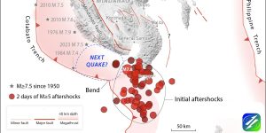
Brought closer to failure by the Feb. 6, 2023, magnitude-7.8 shock, the magnitude-7.5 shock that struck nine hours later caused aftershocks to turn on in some zones and off in …

New findings on Bainbridge Island offer insights into the history and behavior of a complex fault system under Seattle, Washington. By Rebecca Owen, Science Writer (@beccapox) Citation: Owen, …

At 4:17 a.m. on Feb. 6, 2023, a magnitude-7.8 earthquake struck near Pazarcık City in south-central Türkiye, followed by a magnitude-7.5 event about 9 hours later. In this report, scientists …

El segmento Este de la Falla Anatolia en Turquía fue un gigante que despertó el 6 de febrero de 2023, generando un terremoto de Magnitud 7.8, con consecuencias devastadoras. Este …