Utah has experienced energetic earthquakes in the past. If a magnitude-7.0 earthquake hits the state, major cities would feel strong shaking and likely experience events triggered by the shock.
By Meghomita Das, Palomar Fellow (@meghomita)
Citation: Das, M., 2023, Wasatch corridor in Utah prone to big quakes and shakes, Temblor, http://doi.org/10.32858/temblor.293

This article was updated on Jan. 23 and Feb. 1 based on comments from James Pechmann.
Earthquakes regularly shake the U.S. state of Utah, which has experienced 17 earthquakes of magnitude 5.5 or greater since 1847. Evidence also shows that prior earthquakes reached upward of magnitude 6.5. Most of these earthquakes struck along the Wasatch Front that runs in a north-south direction, from southern Idaho to central Utah. Future quakes along this stretch would affect major cities in the state, especially the capital, Salt Lake City.
Because of its earthquake-rich history, several studies have examined the likelihood of future quakes and estimated their theoretical damage. Such studies help scientists determine earthquake hazards, and hint at the precarious nature of life and liability for Utah’s major population centers.

Earthquakes in Utah
Utah is nestled at the intersection of the Rocky Mountains in the east, the Great Basin in the west, and the Colorado Plateau in the southeast. Several active faults splice the state, but the Wasatch Fault is the most hazardous, thanks to its proximity to major cities, says Adam McKean, a geologist and hazard mapper from Utah Geological Survey.
The Wasatch Fault runs along the Wasatch Front region in north-central Utah, and has an 18% probability of one or more magnitude 6.75 or greater earthquakes in the next 50 years. The 390 kilometer-long (240-mile) fault marks the zone between the eastern edge of the Great Basin and the western front of Rocky Mountains and has been divided into 10 segments. The central five segments of this fault are most active and, if they were to rupture individually, could each produce strong quakes. These active fault segments put several major Utah cities at high risk, including Brigham City, Ogden, Salt Lake City, Provo and Nephi.
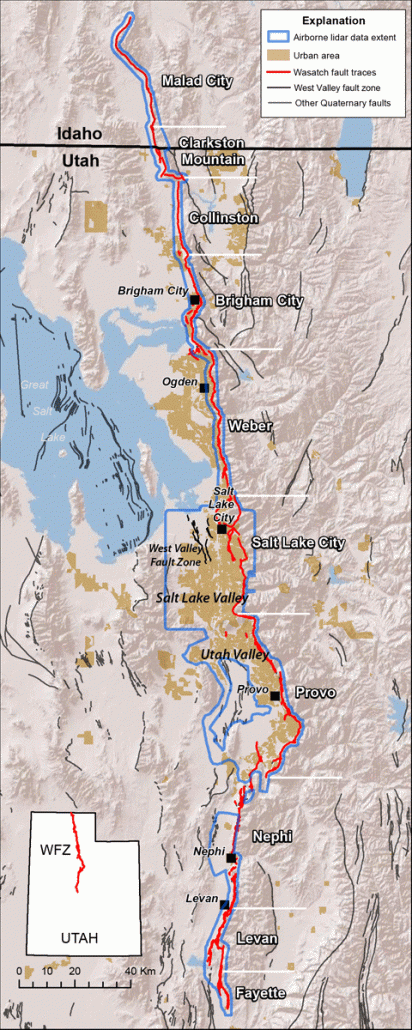
An earthquake probability study revealed that parts of the Wasatch Fault have unleashed earthquakes of approximately magnitude 7.0 — with visible surface ruptures — about once every 300 years. This report compiled previous field-based investigations that documented 22 large earthquakes that broke the surface along the central segments of the Wasatch Fault during the past 6,000 years.
Stretching crust
In the Basin and Range province, the North American Plate stretches and extends. This crust develops normal faults, in which one block moves down relative to another. Specifically, at the Wasatch Fault, the basins of the Basin and Range are dropping down against the Wasatch Mountains to the east, says James Pechmann, a seismologist at the University of Utah.
The Wasatch Fault, along with other active faults in north-central Utah, lies within the Intermountain Seismic Belt that marks the eastern extent of the Basin and Range. “The eastern edge of the Basin and Range has relatively higher rates of extension, which helps to explain the reason behind high seismicity observed in [the Intermountain Seismic Belt in Utah],” says Pechmann. Historical seismicity has been used to estimate that earthquakes of magnitude 5 or larger occur about once every 11 years along the Utah portion of the Intermountain Seismic Belt. Most of the active faults within the Intermountain Seismic Belt extend to depths of between 12 and 18 kilometers (7.5 to 11 miles) and can cause large earthquakes that produce strong ground motions.
Damage to cities
Some of the largest earthquakes documented in this state include the magnitude-6.6 Hansel Valley earthquake in 1934 and the most recent magnitude-5.7 Magna earthquake in 2020. Each of these earthquakes instigated landslides while also damaging buildings, collapsing chimneys, and causing other visible damage to infrastructure in the places near their respective epicenters.
The 2020 earthquake, in particular, commanded a total economic loss of $629 million, with damage to public infrastructure, government-owned buildings and schools. The earthquake also disrupted several public health care centers and the 24/7 COVID-19 hotline service that was implemented in the city during that time.

Due to the historical precedence set by these past earthquakes, the Utah Chapter of the Earthquake Engineering Research Institute developed an earthquake scenario reports. In one report, they provide a specific case study of what a magnitude-7.0 earthquake on the Salt Lake City segment of the Wasatch Fault might look like (Earthquake Engineering Research Institute
(EERI) Utah Chapter, 2015).
An earthquake’s risk is not only controlled by its magnitude, but also by its location. Most of Utah’s population is concentrated in the Wasatch Front urban corridor that includes the five most active segments of the Wasatch Fault. According to the reports, 80 percent of Utah’s population lives within 24 kilometers (15 miles) of the Wasatch Fault in the Wasatch Front area, with more than 75 percent of Utah’s economy concentrated in Salt Lake, Utah, Davis, and Weber counties — all of which include the fault. Additionally, the Wasatch Fault, which dives into Earth’s crust at an angle, dips below Salt Lake City. An earthquake on this fault would provide little time for warning, as the hypocenter would be right below the major city, says Pechmann.
Detailed field investigations of the Wasatch Fault indicate that it experiences long periods of dormancy. Instead of producing smaller magnitude earthquakes in quick succession, this fault tends to store up its energy for highly hazardous, large-magnitude quakes that release more energy. For example, the Salt Lake City and the Brigham City segments of this fault may be more hazardous simply because they haven’t ruptured in 1,400 years and 2,500 years, respectively.
Simulating an earthquake
Understanding the risks associated with a surface-rupturing earthquake and the damage it could wreak is an essential first step to prepare. Simulating such a scenario provides information to state and federal response organizations, such as FEMA, and highlights which areas are at greater risk, and how to fortify them against the most energetic events.
To that end, a team of researchers at the Utah Chapter of the Earthquake Engineering Institute and at the University of Utah developed models to forecast the expected ground-shaking motion from a magnitude-7.0 earthquake along a patch of the Wasatch Fault close to Salt Lake City. The results of the simulation are provided as a ShakeMap — a color-coded map developed by the U.S. Geological Survey that presents the intensity of the earthquake’s shaking on a scale of I-X on the Modified Mercalli Intensity (MMI) scale.
For a hypothetical rupture on the Salt Lake City segment, strong to severe shaking accompanied by moderate to heavy damage would be experienced by those in Salt Lake City and as far as Provo in the south (73 kilometers/45 miles away) and Ogden in the north (56 kilometers/35 miles away). The main event would be followed by aftershocks that could cause additional destruction by further weakening damaged structures and slowing recovery efforts in the area.
The report also provides information about the additional hazards that could be triggered by the temblor. For instance, liquefaction, in which water-saturated ground behaves like a slurry and intensifies the shaking, is a particular problem in the area around Salt Lake City because of the presence of ancient lake-bed sediments. These remnants mark the extent of the ancient approximately 20,000 square mile Lake Bonneville, which last existed 13,000 years ago. The report estimates severe liquefaction in Salt Lake City and West Valley City, two of the most densely populated cities in Utah.
Moreover, due to the elevation difference between the Wasatch Mountains to the east and the Great Salt Lake to the west, landslides are a common occurrence. The damage that would result from a landslide is also affected by weather patterns because snowmelt or prolonged rainfall can saturate a wider area, lubricating the soil and making it more prone to landslides. Weather patterns combined with the effects of a magnitude-7 earthquake would exacerbate damage.
Preparing for the next event
There is a 5.8% percent chance in the next 50 years of a magnitude 6.75 earthquake (or greater) on the Salt Lake City segment of the Wasatch Fault, according to the probability report. With such a forecast, the government and the communities of Utah must prepare and create post-disaster recovery plans.
Of particular concern: Utah has a large stock of unreinforced masonry, says McKean. Much of that stock was built before earthquake building codes were adopted in 1975. Because the largest earthquake recorded on the Wasatch Front since settlement in 1847 was the 1934 magnitude-6.6 Hansel Valley earthquake, most buildings in Utah have not experienced the shaking of a large event. Many have not been updated with proper structural reinforcement, he says.
Besides masonry, infrastructure like water pipelines from the mountains on the east cross the Wasatch Fault to provide water to the population centers on the west side of the fault. Any large movement on the fault will lead to disruption and damage of pipelines, canals and other essential utility services. McKean and his team at the Utah Geological Survey have developed interactive hazard maps for the state that are available on the Survey’s website. They also conduct outreach with the communities, policymakers, state legislature and companies for earthquake preparedness by creating infographics and city ordinances for hazard safety.
The Survey website on earthquake hazards and the interagency website for latest information about earthquakes provide places where Utah residents can get the most up-to-date information about the seismic hazards for their area, as well as steps for mitigating earthquake risks.
Meghomita Das is Temblor’s Palomar Fellow. She is a Ph.D. candidate at McGill University in Montreal, Canada, where she studies the signals of ancient earthquakes and slow slip events (www.meghomita.com). Palomar Holdings is sponsoring a science writing fellow to cover important earthquake news across the U.S.
References
DuRoss, C. B., Hylland, M. D., McDonald, G. N., Crone, A. J., Personius, S. F., Gold, R. D., & Mahan, S. A. (2014). Holocene and latest Pleistocene paleoseismology of the Salt Lake City segment of the Wasatch fault zone, Utah, at the Penrose Drive trench site. Evaluating Surface Faulting Chronologies of Graben-Bounding Faults in Salt Lake Valley, Utah: New Paleoseismic Data from the Salt Lake City Segment of the Wasatch Fault Zone and the West Valley Fault Zone, 1-35.
Earthquake Engineering Research Institute (EERI) Utah Chapter, 2015, Scenario for a magnitude 7.0 earthquake on the Wasatch Fault-Salt Lake City Segment: Hazards and Loss Estimates
Wong, I. G., Lund, W. R., Duross, C., Thomas, P., Arabasz, W., Crone, A. J., … & Rowman, S. (2016). Earthquake probabilities for the Wasatch Front region in Utah, Idaho, and Wyoming. Utah Geological Survey.
Utah Seismic Safety Commission. (2022). Putting down roots in earthquake country: Your handbook for earthquakes in Utah.
- Venezuela’s doublet leaned toward Caracas - June 30, 2026
- Is Southern California’s Cajon Pass an ‘earthquake gate’ ready to open? - June 29, 2026
- Philippines magnitude 7.8 shock may have loaded the central Cotabato subduction zone - June 11, 2026