A magnitude-4.2 earthquake shook Southern California last Friday. The event, with an epicenter 3 miles from Caltech’s Palomar Observatory, was felt widely throughout San Diego and the Los Angeles area.
By Alba M. Rodriguez Padilla, Ph.D. candidate, UC Davis (@_absrp)
Citation: Rodriguez Padilla, A.M., 2023, Palomar Observatory earthquake rocks Southern California, Temblor, http://doi.org/10.32858/temblor.305
As Southern California residents were sitting down to dinner on Friday, March 31, a magnitude-4.2 earthquake rocked the region. The quake, with an epicenter 3 miles (~5 km) northwest of the Palomar Observatory and about 16 miles (25 km) from the city of Temecula, was widely felt around 6 pm. A magnitude-4 event with a similar depth — about 8 miles (13 km) deep — shook the same region in January 2022.

Friday’s quake, which was originally estimated to be a magnitude-4.5, triggered a ShakeAlert that was delivered to smartphones in areas where shaking was expected to exceed a standard threshold. By Sunday evening, more than 7,500 people had reported feeling shaking through the U.S. Geological Survey’s “Did You Feel It?” platform. Residents in communities immediate to the epicenter reported light to moderate shaking, reaching an intensity of 5 on the Modified Mercalli Intensity scale, which describes the strength of shaking at a specific location. Light shaking was felt in population centers up to 100 miles (160 km) away from the epicenter of the quake, including San Diego and the broader Los Angeles area. Friday’s quake was followed by a magnitude-2.8 aftershock on Saturday, felt lightly in nearby population centers.
The Elsinore Fault Zone
The epicenter of Friday’s event was located within the Peninsular Ranges, suggesting the quake occurred on an unnamed fault with the Elsinore Fault Zone. The Elsinore Fault, after which the broader fault zone is named, runs parallel to and west of the San Andreas Fault for over a hundred miles, from the Laguna Mountains near the Mexican border to the Chino Hills southwest of Los Angeles.

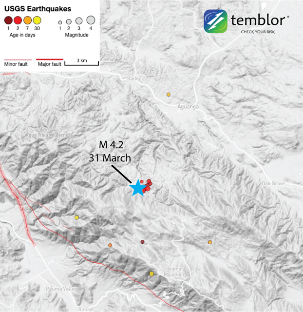 The March 31 earthquake occurred on an unnamed fault in the Elsinore Fault Zone. The last big quake on the Elsinore Fault itself was a magnitude-6 event in 1910.
The last big quake on the Elsinore Fault is estimated to be a magnitude-6 event that occurred in 1910, striking near Lake Elsinore, about 30 miles (almost 50 km) north of Friday’s temblor. A magnitude-4 quake struck on the Elsinore Fault on January 2018, as well.
The focal mechanism reported by the USGS indicates that Friday’s quake occurred on a reverse fault, i.e., a fault that accommodates predominantly vertical motion in response to the crust getting squeezed together by tectonic forces. Saturday’s magnitude-2.8 aftershock, however, reflects lateral motion, which is typically expected on the Elsinore Fault and other major Southern California fault zones (including the San Andreas and San Jacinto), which help accommodate the sliding of the Pacific Plate past the north American Plate. The Elsinore Fault slips at about 5 mm/yr. The San Andreas and San Jacinto faults slip at about 12-22 and 10-16 mm/year, respectively, in Southern California.
Throughout Southern California, reverse faults help accommodate the uplift associated with geometrical complexity, such as bends, on the strike-slip faults that make up the plate boundary. Whether the topography of the Peninsular Ranges is actively growing or is a relic feature that gets advected along the major strike-slip faults in southern California remains an open question for geoscientists. Friday’s quake serves as a reminder that active reverse faults exist within the Peninsular Ranges and are capable of generating widely felt quakes.
Southern California is Earthquake Country
With an average of more than 30 earthquakes exceeding magnitude 4 per year, Southern California is no stranger to seismic shaking. To prepare for future events, residents should download the ShakeAlert app and prepare an earthquake kit. If you feel shaking, drop, cover, and hold on.
- Venezuela’s doublet leaned toward Caracas - June 30, 2026
- Is Southern California’s Cajon Pass an ‘earthquake gate’ ready to open? - June 29, 2026
- Philippines magnitude 7.8 shock may have loaded the central Cotabato subduction zone - June 11, 2026