New findings on Bainbridge Island offer insights into the history and behavior of a complex fault system under Seattle, Washington.
By Rebecca Owen, Science Writer (@beccapox)
Citation: Owen, R., 2023, Piecing together the puzzle of the Seattle Fault Zone, Temblor, http://doi.org/10.32858/temblor.298
A fault system with several tendrils snaking underneath Puget Sound is capable of producing dangerous earthquakes below the skyscrapers, hilly neighborhoods and islands surrounding Seattle’s urban core. Many questions remain unanswered about the Seattle Fault Zone, including how frequently earthquakes may happen, as well as where they might occur and how damaging they could be. Now, new findings offer clues to the Seattle Fault Zone’s history and the earthquakes it is capable of producing.

The fault zone
The Seattle Fault Zone consists of three main east-west traces that stretch from the Olympic Peninsula, across Bainbridge Island and Elliot Bay and through Seattle into the edge of the Cascade Mountains. The last major earthquake on the Seattle Fault occurred around 1,100 years ago, shifting the landscape in Puget Sound. That earthquake, likely between magnitude 7 and 7.5, lifted the southern end of Bainbridge Island and West Seattle more than 20 feet (6 meters), generated a tsunami, and created landslides into Lake Washington, says Bill Steele, director of communications for the Pacific Northwest Seismic Network. “It would have been a really interesting time to be around, if I had a safe tent.”
Today, a marine terrace — the raised platform shoreline at Alki Point in West Seattle and Restoration Point on Bainbridge Island that was lifted during the historic earthquake — is a visual reminder of how the Puget Sound landscape changed 1,100 years ago. But fresh discoveries on Bainbridge Island hint at a much more recent earthquake that complicates the region’s seismic history.
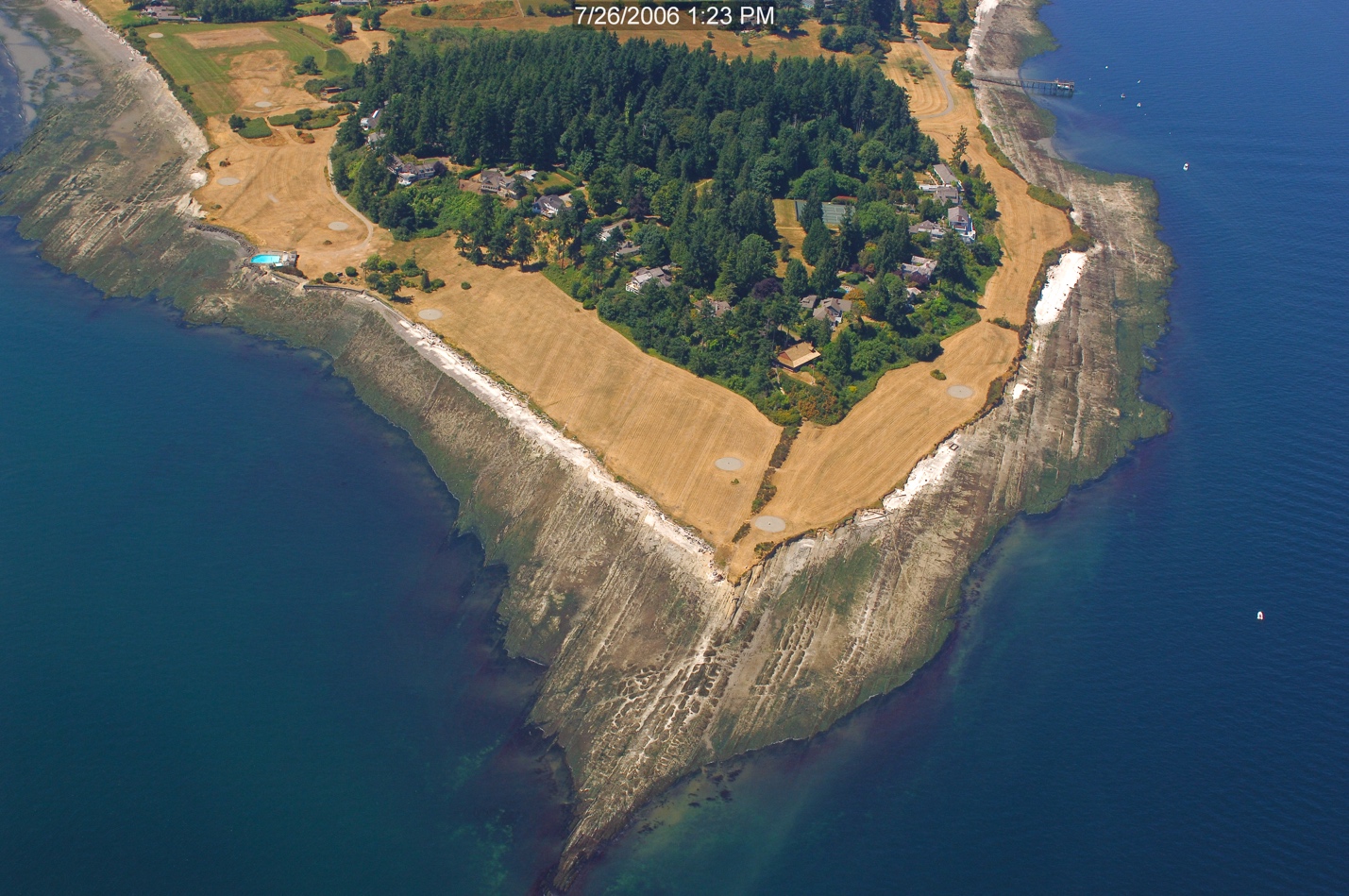
Tracing new evidence on Bainbridge Island
Bainbridge Island is a 35-minute ferry ride from downtown Seattle. While the island is a suburb of the city, much of its terrain is steep and heavily wooded. Using lidar imaging, researchers have identified several fault scarps — locations where previous movement from earthquakes can be seen at the surface. The scarps on Bainbridge Island represent smaller earthquake ruptures of secondary faults — offshoots of the main fault in the Seattle Fault Zone — and offer important clues to the mechanics of faulting and potential power of the entire fault zone.
In between known fault scarps on Bainbridge, Stephen Angster, a research geologist for the U.S. Geological Survey Earthquake Science Center, and his team discovered a previously unknown fault scarp that can be traced continuously across the island’s narrow midsection. At the western end of the scarp, a localized uplifted marine terrace hints at a more recent undocumented event associated with this newly identified fault scarp.
To determine the recurrence time of earthquakes on this fault, the team dug a trench across the scarp. This short slice across the scarp revealed evidence of possibly two earthquakes separate from the big earthquake that changed the Puget Sound landscape 1,100 years ago. Preliminary results from carbon dating of charcoal in the trench indicated that the earliest earthquake could have happened relatively soon after the last glacial maximum around 15,000 years ago, Angster says. The most recent event happened less than 5,000 years ago. Further charcoal dating from the sand sediments of the uplifted inner tidal sands in the marine terrace may further constrain the date of the most recent event even further to less than 1,000 years ago, he says.

Another piece of the puzzle might come from a wetland area along the fault trace that may have formed during the most recent earthquake. Angster and his colleagues are currently analyzing results from cross-dating dead tree snags in the wetland to living trees nearby. The dead trees were killed around 1833, which could possibly be the time of the last event. The evidence seems to be growing for a near historic event within the Seattle Fault zone, says Angster, but more analysis must be completed.
“So far, it looks like we are capturing the oldest and probably the youngest event in the entire Seattle Fault Zone,” says Angster, who presented the findings at the fall meeting of the American Geophysical Union in Chicago in December 2022. “In terms of earthquake timing, we don’t see any overlap, which suggests that this fault” — now known as the Rose Hip Fault — “ruptures independently from the others, even the main one.”

Their work offers new insights on how these shorter faults might impact the nearby landscape. “These are very short faults that some think cannot generate significant earthquakes, but paleoseismic evidence, such as this study is showing, suggest otherwise,” says Angster.
Not the only earthquake
While “The Big One” still looms at the forefront of Pacific Northwesterners’ nightmares, a Seattle Fault Zone rupture may be more devastating to the city of Seattle than a Cascadia Subduction Zone event. Cascadia would disrupt life for a wide swath of the West Coast while a Seattle Fault Zone earthquake would harm the population centers of the Puget Sound more acutely. “The big basin that this fault system has created under Seattle … resonates and amplifies the ground motion,” says Steele. Considering all the tall buildings that are located on top of this basin, he says, “it’s kind of a frightening situation.”
Understanding the Seattle Fault Zone’s size, scope, history and behavior will hopefully encourage updates to Seattle-area codes for buildings, bridges and infrastructure to save lives when a major earthquake occurs. “We still have a limited number of data points over a long period of time — and nature does have a tendency to throw curveballs. You think you understand, and then you get something different,” says Steele. “But we’re bringing knowledge together so that we really do grow our understanding of how the fault system works.”
References
Angster, S. J., Sherrod, B. L., Pearl, J. K., Staisch, L., and Johns, W., 2022, Paleoseismic Evidence for a Near Historic rupture within the Seattle fault zone: Implications for complex hanging wall kinematics above an active blind reverse fault, Fall Meeting of the American Geophysical Union, December 2022, Chicago, IL. https://agu.confex.com/agu/fm22/meetingapp.cgi/Paper/1168697
- Venezuela’s doublet leaned toward Caracas - June 30, 2026
- Is Southern California’s Cajon Pass an ‘earthquake gate’ ready to open? - June 29, 2026
- Philippines magnitude 7.8 shock may have loaded the central Cotabato subduction zone - June 11, 2026