As Hurricane Hilary lashes the southwestern U.S., some may wonder if an earthquake could result. Not likely, scientists say.
By Alice R. Turner, Ph.D., Simpson Strong-Tie Fellow (@SeismoAlice)
Citation: Turner, Alice R., 2023, How many Hurricane Hilarys would it take to trigger an earthquake? Probably a lot, Temblor, http://doi.org/10.32858/temblor.318

Hurricane Hilary is forecasted to be an extremely rare flooding event — one that occurs on average every 2,000 years. Hilary, which has made landfall as of this writing, is expected to bring an unprecedented amount of rainfall to southern California and the southwestern U.S. There is some concern that the additional water could increase the risk of earthquakes along the southern San Andreas fault. Just how likely is that scenario? Not very.
The Storm
Hurricane Hilary is the first tropical storm to make landfall in California in more than 80 years, bringing with it high winds and rain. Some parts of California and Nevada can experience significant flooding with some local events exceeding a 1,000 year return period, says Dag Lohmann, CEO and co-founder KatRisk, a catastrophe modeling company. Areas in typically arid Southern California could experience one or two times the annual average rainfall of 5 to 10 inches falling within a few days, he says.

The excessive rainfall has to go somewhere. Though much of the rain is likely to run off, eventually flowing into the ocean, there will be an increase in lake water levels, as well as more groundwater stored beneath our feet. This could potentially alter the behavior of faults in southern California.
Water and faults
Most of the time, earthquakes are caused by tectonic stresses that “load” a fault until the two sides slide past each other, releasing that energy in an earthquake. Water can also cause stress changes, both when water accumulates on the surface and when it infiltrates the ground and reaches the faults themselves.
When water sits on the surface, either as water in lakes or reservoirs, or frozen as snow or ice, it is heavy. That weight can cause the ground under the water to bend and deform. “Every surface load on the earth produces deformation,” says Roland Bürgmann, a professor in the Department of Earth and Planetary Science at U.C. Berkeley. “The deformation creates forces within the earth, which might result in an earthquake.” The additional load at the surface, like a watery hand pressing downward, can either promote or limit slip on a fault.
When water seeps into the ground, it can also trigger an earthquake by altering the stresses acting on the fault. The presence of water helps to decrease the forces that are clamping the two sides of the fault shut. “But it may take time for this process to take effect, as water takes a long time to travel through the rock,” Bürgmann explains. How much delay there is depends on the properties of the rock and how easy it is for the water to reach the fault. But once the water is there, it can “trigger some earthquakes,” he says.

Water sometimes causes quakes
The influence of water in causing earthquakes has been observed around the world by scientists. In regions such as Oklahoma and Texas, injecting wastewater into the ground can induce earthquakes. In the Nepalese Himalaya, the summer monsoons load the ground with water. This loading can press the two sides of the fault together and prevent the fault from slipping in an earthquake. The result: the seismicity rate in winter is about twice that in summer.
However, correlations between weather and seismic activity don’t always appear. In Taiwan, the 2009 typhoon Morakot, the largest typhoon in 60 years, seemed to have little to no effect on the seismicity of the island.
Also, the links between rainfall and seismicity have mostly been made through observations of small-magnitude earthquakes. “It’s easier to establish a connection with small earthquakes because, in that case, there might be a few hundred of them,” Bürgmann says. With many earthquakes, it is possible to demonstrate a statistical correlation between rainfall and seismic activity.
“It is more challenging to study large earthquakes,” Bürgmann explains, because they happen far more rarely than small events. “However, triggering can involve both small and large earthquakes,” he says, “so we shouldn’t rule [triggering of large earthquakes by water-related processes] out altogether.”
Ancient lake caused California quakes
Scientists have explored whether there is a relationship between water and the occurrence of large earthquakes. In a recent study published in Nature, researchers analyzed the timing of major earthquakes on the southern San Andreas Fault, which runs near the modern-day Salton Sea. Before there was the Salton Sea, a far larger lake existed — Lake Cahuilla.
The study revealed that six major earthquakes occurred when Lake Cahuilla was full. Using numerical modeling, researchers explored why. The combination of the weight of the lake pressing down in one place, causing the Earth’s surface to sag, along with water at depth changing the pressure — and unclamping the fault — appears to be the cause of this correlation, says Yuri Fialko, the study’s co-author and professor of Geophysics at Scripps.
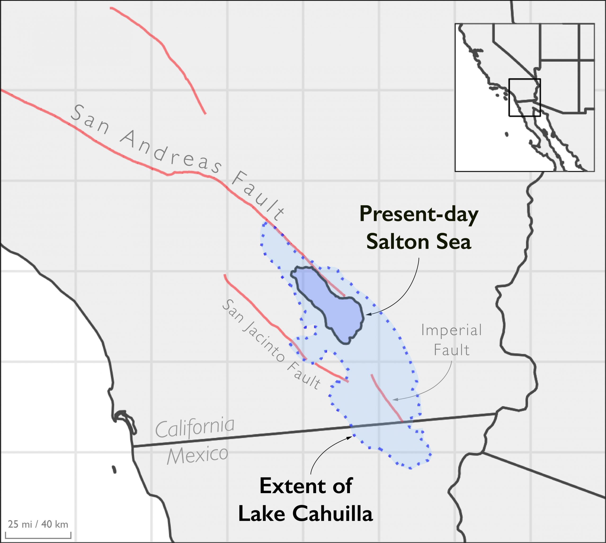
Present-day Salton Sea
Today, Lake Cahuilla is mostly gone, with the Salton Sea left in its stead. The Salton Sea is a shallow, salty inland lake 40 times smaller than Lake Cahuilla. Rainwater from the storm will enter the lake, but it does not have any oceanward outlets. The only exits for the water are to either seep into the ground or evaporate into the air. In California’s arid climate, drought has been shrinking the Salton Sea for decades.
Even if the area receives as much as 10 inches of rainfall during Hurricane Hilary, Fialko says this still would not be enough water to cause a large earthquake like those observed in the study. “When we think about how much the water level will change during the storm, it will be very small compared to the previous fluctuations in the lake level that caused it to fill,” Fialko says. The prehistoric great earthquakes were triggered by a lake level rise of 90 meters (300 feet).

The weight of the initial water dumped by the storm may not be sufficient, but what about the other mechanism of causing earthquakes — when water seeps into the ground? Water infiltrating down to the faults — up to 10 kilometers below the surface — takes time. Fialko explains that during this time, it is likely that the rainwater will dry up.
In the past, the ancient lake was filled by water from the Colorado River, not just rain alone. “We would have to have a constant storm for years,” says Fialko, to fill the lake to its former levels.
Thus, it is highly unlikely that water from the storm will cause an earthquake, but Bürgmann says that it cannot be completely ruled out. Thankfully, extensive seismometer networks and data exist that will allow scientists to monitor any potential effects.
If you’re interested in reading about the earthquake sequence near Ojai, Calif. that produced a magnitude-5.1 event during the tropical storm’s downpours, please check out this story.
Alice Turner is Temblor’s Simpson Strong Tie Fellow. She is a distinguished postdoctoral fellow at the University of Texas Institute for Geophysics, where she uses seismic observations to understand the mechanics of earthquakes, both on the Earth and on other planets. Simpson Strong Tie is sponsoring their second Temblor science writing fellow to cover important earthquake news across the globe.
References
Hill, R. G., Weingarten, M., Rockwell, T. K., & Fialko, Y. (2023). Major southern San Andreas earthquakes modulated by lake-filling events. Nature, 1-6.
Bollinger, L., Perrier, F., Avouac, J. P., Sapkota, S., Gautam, U. T. D. R., & Tiwari, D. R. (2007). Seasonal modulation of seismicity in the Himalaya of Nepal. Geophysical Research Letters, 34(8).
Zhai, Q., Peng, Z., Chuang, L. Y., Wu, Y. M., Hsu, Y. J., & Wdowinski, S. (2021). Investigating the impacts of a wet typhoon on microseismicity: A case study of the 2009 typhoon Morakot in Taiwan based on a template matching catalog. Journal of Geophysical Research: Solid Earth, 126(12), e2021JB023026.
Copyright
Text © 2023 Temblor. CC BY-NC-ND 4.0
We publish our work — articles and maps made by Temblor — under a Creative Commons Attribution-NonCommercial-NoDerivatives 4.0 International (CC BY-NC-ND 4.0) license.
For more information, please see our Republishing Guidelines or reach out to news@temblor.net with any questions.
- Venezuela’s doublet leaned toward Caracas - June 30, 2026
- Is Southern California’s Cajon Pass an ‘earthquake gate’ ready to open? - June 29, 2026
- Philippines magnitude 7.8 shock may have loaded the central Cotabato subduction zone - June 11, 2026