New models add to the evidence that stress changes from prehistoric Lake Cahuilla helped trigger past large earthquakes.
By Laura Fattaruso, M.S., Ph.D. Candidate, UMass Amherst (@labtalk_laura)
Citation: Fattaruso, L., 2021, Disappearance of ancient lake may explain earthquake gap in Southern California, Temblor, http://doi.org/10.32858/temblor.162
Over the last millennium, the southern San Andreas Fault has produced a large earthquake roughly once every 180 years — give or take 40 years (Rockwell et al., 2018). But the last big shock was in 1726 — just shy of 300 years ago — suggesting that the region is overdue for a large, destructive earthquake.
“Everyone is interested in the question: when’s the next big one?” explains Ryley Hill, a doctoral student in the Earthquake Science and Applied Geophysics joint program between San Diego State University and UC San Diego. Hill recently presented research on a potential cause of the extended quiescence of the southern San Andreas Fault at the 2020 Geological Society of America Meeting. Hill explains that based on analysis of earthquake recurrence intervals, there was a 95% probability of a large earthquake by 2020. So why hasn’t it happened yet?
An enormous lake dries up
Over the same time period, an enormous lake has appeared and disappeared from the northern Salton trough — a large inland basin that includes the Coachella and Imperial Valleys, through which the San Andreas Fault runs. The drainage of the Colorado River has shifted between the Gulf of California and the Salton trough, filling up to form a large freshwater lake, and then drying up into desert in a cycle that has repeated several times over a few thousand years. This was prehistoric Lake Cahuilla, and some geologists think its repeated filling and draining might have helped to trigger the large earthquakes of the past.
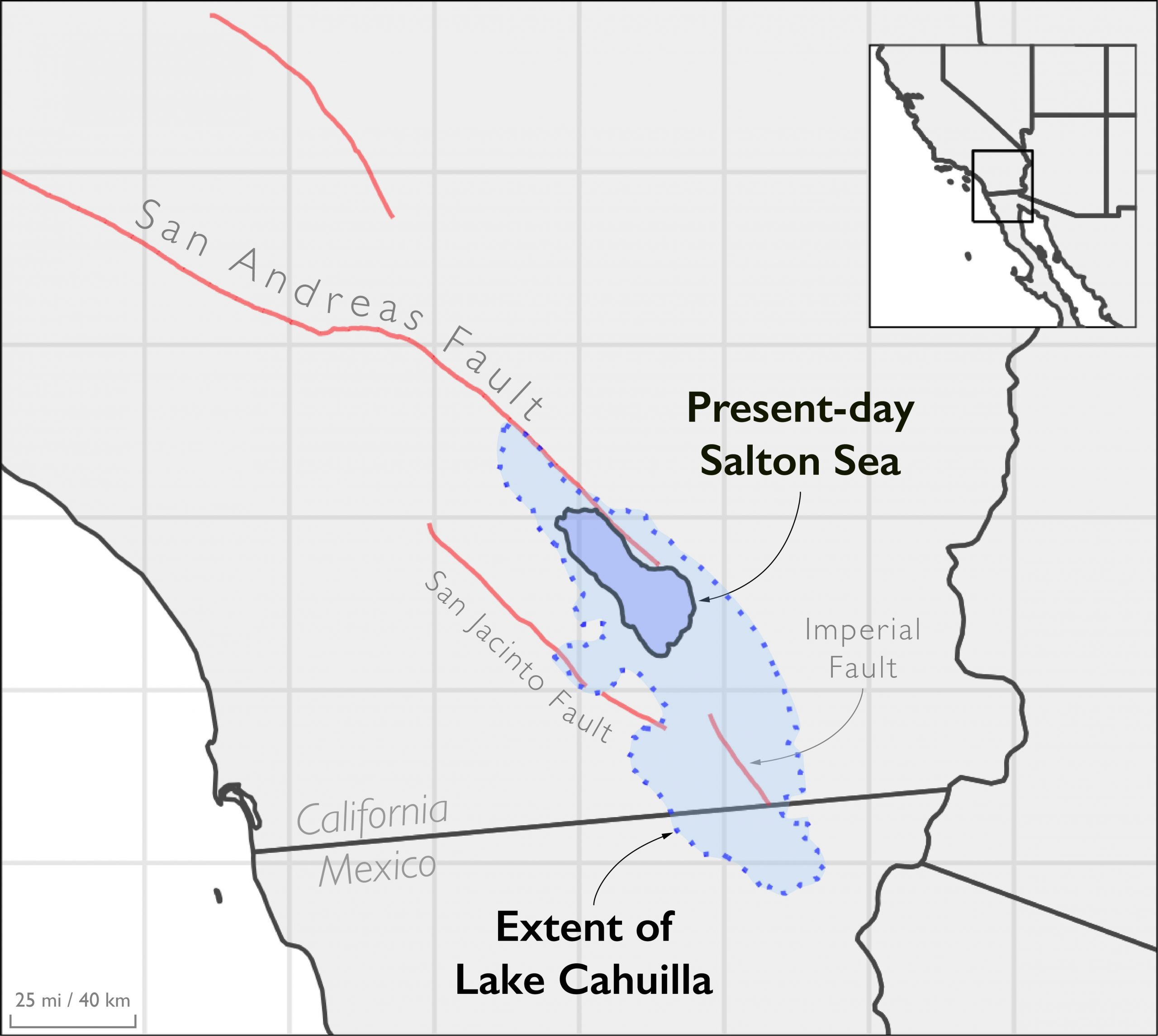
Geologic records indicate that the basin has been mostly dry since about 1725. Floodwaters breeched manmade irrigation canals in 1905, partially filling the depression and forming the present-day Salton Sea. Despite being one of the biggest lakes in present-day California, the Salton Sea is dwarfed by prehistoric Lake Cahuilla. The Salton Sea maxes out at a depth of about 43 feet (13 meters), whereas Lake Cahuilla was as deep as 330 feet (100 meters). At its peak, Lake Cahuilla covered about a 6 times larger map area than Salton Sea.
No lake, no quake?
“It’s an interesting alignment of two datasets; no lakes and no earthquakes in the last 300 years is something people have noticed for a long time. As we get more [data] on the timing of the lakes and the earthquakes, it looks more and more interesting,” says Karen Luttrell, a geophysicist at Louisiana State University, who was not involved with the new study.
In an earlier study, Luttrell and colleagues found that bending and unbending of the Earth’s crust from the weight of the lake water could have affected the stress on the faults beneath Lake Cahuilla. The resulting change in stress could have triggered an earthquake (Luttrell et al., 2007). Hill and his collaborators’ new research adds hydrologic complexity to the story by considering how the diffusion of water through the crust plays a role in stress changes through time.
In his presentation, Hill explains that the water from the lake affects the pressure within the pore space of the rocks below it in a few different ways. First, the added weight of the water increases pressure in the crust below it — this happens immediately when the lake fills. Then, as the water percolates through the ground and through deeper layers of the crust, pore pressure continues to change and evolve over time in a more complex way. Hill explores how these interacting processes affect the stress conditions where the San Andreas fault cuts through the crust. Even portions of the fault that are north of Lake Cahuilla still undergo stress changes.
Adding the effects of diffusion into simulations of fault failure increases the estimates of earthquake-triggering stress changes by 2-3 times, says Hill. “[Increasing] pore pressure always drives the fault towards failure.”

The hazard remains
A mostly dry Salton Trough doesn’t mean that southern California can forget about “the big one” coming soon, though.
“Regardless of whether the lake modulated the process in the past — from tectonic loading — the current potential for an earthquake is still very, very high,” says Hill.
Fundamentally, earthquakes on the San Andreas Fault are driven by plate tectonics. While other factors like the coming and going of lakes or glaciers can have an impact on the timing of major quakes, tectonic stress is still accumulating. Since the last big rupture, the southern San Andreas fault has accumulated ~6 meters of slip that has yet to be realized — enough to produce an earthquake larger than magnitude-7.0 (Fialko, 2006; Rockwell et al., 2018).
“Understanding southern San Andreas fault rupture is a worthy endeavor, and this is one piece of the puzzle,” says Luttrell.
References
Brothers, D., Kilb, D., Luttrell, K., Driscoll, N., & Kent, G. (2011). Loading of the San Andreas fault by flood-induced rupture of faults beneath the Salton Sea. Nature Geoscience, 4(7), 486-492.
Fialko, Y. (2006). Interseismic strain accumulation and the earthquake potential on the southern San Andreas fault system, Nature 441, 968–971.
Luttrell, K., Sandwell, D., Smith‐Konter, B., Bills, B., & Bock, Y. (2007). Modulation of the earthquake cycle at the southern San Andreas fault by lake loading. Journal of Geophysical Research: Solid Earth, 112(B8).
Rockwell, T. K., Meltzner, A. J., & Haaker, E. C. (2018). Dates of the two most recent surface ruptures on the southernmost San Andreas fault recalculated by precise dating of Lake Cahuilla dry periods. Bulletin of the Seismological Society of America, 108(5A), 2634-2649.
- Venezuela’s doublet leaned toward Caracas - June 30, 2026
- Is Southern California’s Cajon Pass an ‘earthquake gate’ ready to open? - June 29, 2026
- Philippines magnitude 7.8 shock may have loaded the central Cotabato subduction zone - June 11, 2026