The devastating earthquake that struck Morocco on September 8, 2023 killed thousands of people. It was not unprecedented, although it did occur in a less seismically active zone than other Moroccan quakes.
By José A. Peláez, University of Jaén, Spain
Citation: Peláez, J. A., 2023, Deadly Morocco quake resulted from Africa’s ongoing collision with Europe, Temblor, http://doi.org/10.32858/temblor.321
Cet article est également disponible en français.
Este artículo también está disponible en español.
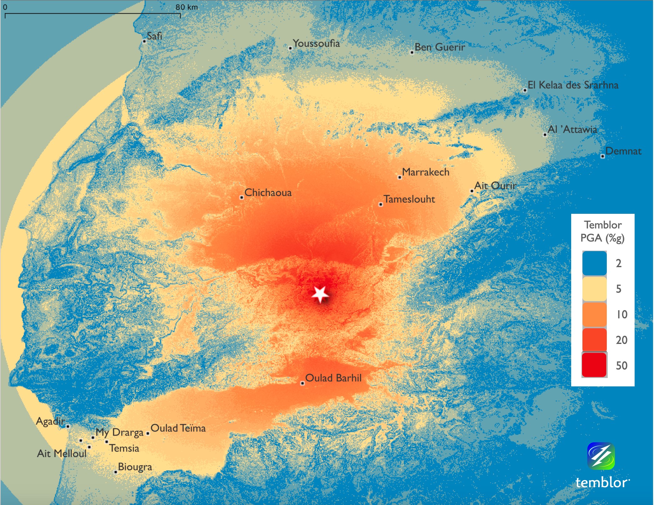
On Sept. 8, 2023, just after 11 p.m. local time, a magnitude-6.8 earthquake ripped through a mountainous area about 75 kilometers southeast of Marrakech, Morocco. Nearly 3,000 people have died as of this writing, and hundreds more are injured or missing. Emergency workers are having a hard time reaching remote villages nearest the epicenter of the quake due to damaged roads, so it may be some time before the true toll is known. Images from the region show complete devastation in some mountain villages. The quake was felt as far away as Spain and Portugal.
The quake struck about 26 kilometers deep in the High Atlas Mountains, according to the U.S. Geological Survey. The USGS focal mechanism solution suggests that the event either occurred along a shallowly dipping oblique-reverse fault striking to the southeast or a steeply dipping oblique-reverse fault striking to the east. An oblique-reverse fault implies that as one side of the fault shoves upward relative to the other, both sides also move laterally.

The USGS PAGER rapid impact assessment system projects high casualties and extensive damage, which is supported by news reports of flattened villages near the epicenter and crumbling buildings, especially in oldest parts of Marrakech, which was founded in the 11th century. Many buildings in the region are made with unreinforced masonry construction. These adobe-mud and brick-and-mortar buildings — especially centuries-old structures in ancient cities like Marrakech — are not built to withstand shaking.
Tectonics
Earthquakes in this region are intraplate events, meaning that they occur far from a plate boundary. The epicenter of Friday’s earthquake was about 500 kilometers from the boundary between the Eurasian Plate to the north, and the African Plate, and more specifically the Nubian Plate, to the south.
The effects of convergence of the Eurasian and Nubian plates in the region between the Iberian Peninsula and westernmost Africa, known as the Ibero-Moghrebian region, are not limited strictly to the Azores-Gibraltar transform zone and the northern Moroccan coast (De Mets et al., 2010). This convergence also propagates to the south, affecting the Moroccan Meseta (Figure 1) that consists of Paleozoic rocks. This zone of influence reaches the Atlas Belt, as shown by Chalouan et al. (2023) using continuous GPS data. This implies a shallow shortening in the Atlas Cordillera, including the High Atlas Mountains, where the Sept. 8, 2023, magnitude-6.8 shock struck. The GPS data suggest a shortening rate of about 1 millimeter per year in the High Atlas.
The principal range-bounding faults mapped in the western High Atlas strike NE-SW, such as the El Kléa and the Biougra reverse faults (Mridekh, 2002). The observed shortening implies reverse and strike-slip motion, consistent with the focal mechanism solution computed by the USGS for the Sept. 8 shock. Various studies indicate that these faults have been moving for the past 6 million years or so, and are associated with the formation of folds in the Atlas Mountains foreland (Aït Brahim et al., 2002).

In addition, as several researchers highlight, the Atlas Mountains present an unusual thinning of the lithosphere, the most superficial and rigid layer of Earth, combined with anomalous strong uplift of the mantle (Chalouan et al., 2023). This uplift may be associated with Neogene volcanism in the Middle Atlas and Permian volcanism in the western High Atlas (Chalouan et al., 2023; Loudaoued et al., 2023).
Historic events
Considering the historical earthquake record for the past thousand years, earthquakes that affect Morocco tend to occur in two areas. The first region of seismicity lies offshore and to the north of Morocco, along the Azores-Gibraltar transform zone and its eastward continuation into the Alboran Sea. The other is onshore, along the Rif Mountains in northern Morocco and the Tell Atlas in northwestern Algeria. In contrast, earthquakes along the Atlas Belt, like the one that occurred on Sept. 8, are far less common.

Recently, the most significant earthquakes to affect Morocco were the 1994, 2004 and 2016 Al-Hoceima earthquakes (Hamdache et al., 2022), with magnitudes ranging between 6.0 and 6.3. These events, all centered around Al-Hoceima in northernmost Morocco, struck in the most seismically active part of the country.
In the so-called historical period, prior to the establishment of seismometers, several significant events have also been recorded in Morocco. Among them is the 1624 Fès earthquake, with an estimated magnitude of 6.7.
We cannot forget the Agadir earthquake in February 1960, which was originally reported as a magnitude-6.3 event, but eventually revised to about magnitude 5.9. The Agadir earthquake was approximately located at the boundary between the Western High Atlas and the Anti Atlas that lies to the south. Earthquakes in this area are not without precedent. An earthquake of similar magnitude struck the same region in 1731 (Peláez et al., 2007). Near the place where the catastrophic event of Sept. 8 occurred, another event struck in April 1955, near Oued Nfiss, which was felt with intensity VIII (on the Modified Mercalli Scale) in some towns, with a probable magnitude equal to 5.8 (Peláez et al., 2007).
Repercussions
The available data suggest that 12,000 to 15,000 people died in the 1960 Agadir event, and 630 perished in the 2004 earthquake. At the time of this writing, nearly 3,000 victims of the catastrophic Sept. 8 earthquake have been reported. So, sadly, earthquakes and their consequences are not unusual in Morocco.
As seismologists know, earthquakes cannot be predicted. In fact, many researchers think that it will not be possible to do so in the future, either. What we can do, however, is to establish the areas in which earthquakes are most likely to occur, and at best, present the probability of their occurrence and the associated uncertainty.
It is very important to conduct seismic hazard studies in places like Morocco based on knowledge of active tectonic structures and past seismicity — both historical and instrumental. The greater the knowledge that one has on these two topics, the more insight one will have about an area’s future seismicity and the associated uncertainty.
Finally, the best tool we have to mitigate the impact of earthquakes is to implement the findings of seismic hazard assessment studies into national building codes. This is the way engineers can incorporate the appropriate level of seismic safety in building or infrastructure designs. Buildings that were constructed without regard to regulations and without the requisite structural support are potential killers. This is the reason why building codes must be mandatory, why buildings must be inspected, and why codes should be updated periodically. This is the best — and perhaps only — way to protect ourselves against these catastrophic phenomena.
In Morocco, those responsible for safety — rulers and government planners — must understand this and take it into account for the future. Otherwise, nothing can be done to prevent what happened.
Science editor: Dr. Alka Tripathy-Lang, Ph.D.
Reviewer: Dr. Ross S. Stein, Ph.D.; Dr. Wendy Bohon, Ph.D.
References
Aït Brahim, L., Chotin, P., Hinaj, S., Abdelouafi, A., Nakhcha, C., Dhont, D., Sossey Alaoui, F., Bouaza, A., Tabyaoui, H., and Chaouni, A. (2002). Paleostress evolution in the Moroccan African margin from Triassic to present. Tectonophysics 357, 187-205.
Chalouan, A., Gil, A.J., Chabli, A., Bargach, K., Liemlahi, H., El Kadiri, K., Tendeero Salmerón, V., and Galindo Zaldívar, J. (2023). cGPS record of active extension in Moroccan Meseta and shortening in Atlasic chains under Eurasia-Nubia convergence. Sensors 23, 4846.
De Mets, C., Gordon, R.G., and Argus, D.F. (2010), Geologically current plate motions. Geophysical Journal International 181, 1-80.
Hamdache, M., Peláez, J.A., Gospodinov, D., Henares, J., Galindo Zaldívar, J., Sanz de Galdeano, C., and Ranguelov, B. (2022). Stochastic modeling of the Al Hoceima (Morocco) aftershock sequences of 1994, 2004 and 2016. Applied Sciences 12, 8744.
Loudaoued, I., Touil, A., Aysal, N., Aissa, M., Keskin, M., Yilmaz, I., and Ouadjou, A. (2023). Volcanic rocks from Amensif-Tnirt district in the western High Atlas (Morocco): Geochemistry, magma features and new age dating. Journal of African Earth Sciences 205, 104975.
Mridekh, A. (2002). Géodynamique des bassins méso-cénozoiques de l’offshore d’Agadir (Maroc sud occidental). Contribution à la connaissance de l’évolution atlasique d’un segment de la marge atlantique marocaine. PhD Thesis. Faculty of Sciences, Kenitra, Morocco.
Peláez, J.A., Chourak, M., Tadili, B.A., Aït Brahim, L., Hamdache, M., López Casado, C., and Martínez Solares, J.M. (2007). A catalog of main Moroccan earthquakes from 1045 to 2005. Seismological Research Letters 78, 614-621.
https://earthquake.usgs.gov/earthquakes/eventpage/us7000kufc/executive
Copyright
Text © 2023 Temblor. CC BY-NC-ND 4.0
We publish our work — articles and maps made by Temblor — under a Creative Commons Attribution-NonCommercial-NoDerivatives 4.0 International (CC BY-NC-ND 4.0) license.
For more information, please see our Republishing Guidelines or reach out to news@temblor.net with any questions.
- Venezuela’s doublet leaned toward Caracas - June 30, 2026
- Is Southern California’s Cajon Pass an ‘earthquake gate’ ready to open? - June 29, 2026
- Philippines magnitude 7.8 shock may have loaded the central Cotabato subduction zone - June 11, 2026