The magnitude-6.4 earthquake didn’t damage infrastructure, but it’s the latest to remind us that the Manila trench can generate big quakes near a populous metropolis.
By Mario Aurelio, Sandra Donna Catugas, John Agustin Escudero, Structural Geology and Tectonics Laboratory at the University of Philippines National Institute of Geological Sciences, Alfredo Mahar Francisco Lagmay, Executive Director, University of the Philippines Resilience Institute-Nationwide Operational Assessment of Hazards Center (@nababaha), Giovanni Tapang, Emil Joseph Mateo, University of Philippines National Institute of Physics
Citation: Aurelio, M., Catugas, S.D., Escudero, J. A., Lagmay, A.M.F., Tapang, G. and Mateo, E.J., 2022, Shallow earthquake strikes west of Manila, Philippines, Temblor, http://doi.org/10.32858/temblor.249
On March 14, 2022, at 5:05 a.m. local time, a shallow magnitude-6.4 earthquake struck off the coast of Lubang Island.
If a shallow magnitude-6.4 earthquake were to strike on land, significant damage to infrastructure would be sustained. However, because it struck far offshore the latest event only caused high-rise buildings to sway, awakening light-sleepers in Manila, 200 kilometers (125 miles) away. Though too weak to cause damage at such a distance, this event, along with its six predecessors suggest continued vigorous activity along the Manila Trench, which is capable of generating even larger earthquakes. Should one occur, serious destruction to the Manila and surrounding metropolis — home to more than 25 million people — would almost certainly result.
Earthquake Pattern
The recent epicenter is just north of where six magnitude-5.0 and greater earthquakes struck in the latter half of 2021. Unlike last year’s events, however, the latest quake ruptured a normal fault. Where the oceanic South China Sea plate enters the Manila Trench, the crust flexes as it bends downward toward the mantle. Such regions — known as flexural bends — can be pulled apart even as, overall, the area is compressed as one tectonic plate is thrusted over the other. The earlier six earthquakes struck on thrust faults, but all seven earthquakes occurred in the same oceanic tectonic plate, highlighting how complex such subduction zones can be.

This month’s earthquake occurred only three months after the last big shock. The series of earthquakes started on July 24, 2021, with a magnitude-6.6 mainshock followed by a magnitude-5.7 aftershock. A magnitude-5.8 earthquake struck on August 13. A fourth quake — a magnitude-5.7 — struck on September 27, and was followed by a magnitude-5.2 event on October 7 and a magnitude-5.5 quake on December 13.
These six 2021 earthquakes ruptured at depths ranging from 80 to 110 kilometers (50-70 miles), unlike the March earthquake, which ruptured a mere 11 kilometers (7 miles) deep. The location of its epicenter indicates that the earthquake struck along a fault west of the Manila Trench. The quake’s normal motion and shallow depth indicate that the fault is related to the flexing of the South China Sea oceanic plate as it bends into the subduction zone. Conversely, the six previous earthquakes likely occurred in the part of the tectonic plate that had already turned the corner and is now somewhere below the overriding Philippine plate.

The focal mechanism of the most recent earthquake shows two normal fault planes oriented roughly northwest-southeast. Three days after the mainshock, the Philippine Institute of Volcanology and Seismology (PHIVOLCS) detected three magnitude-5.0 or greater aftershocks and about fifteen that were magnitude 4.0 or greater. The focal mechanisms of the magnitude-5.0 or greater aftershocks show a northwesterly striking normal fault, consistent with the focal mechanism of the mainshock. More than a week after the mainshock, aftershocks between magnitude 2.0 and 3.0 are still being recorded.
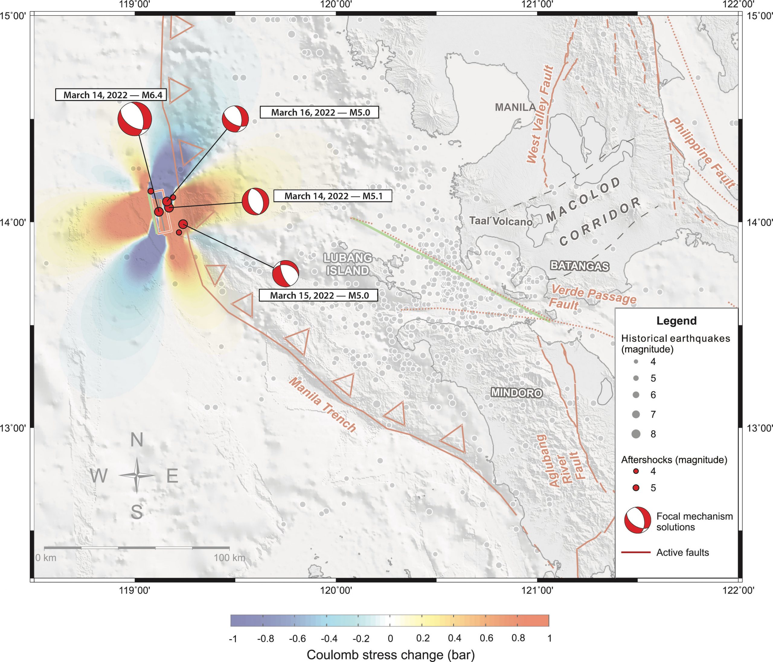
Coulomb Stress Transfer modeling is a technique that helps scientists identify the regions where stress is transferred after an earthquake. Earthquakes are promoted along faults located where stresses accumulate or increase. Using the structure that generated the mainshock as the source of the March earthquake and the closest known active fault — the sinistral Verde Passage Fault — as the receiver fault (meaning, the fault receives the stress transferred from the source), we find that the magnitude-5.0 or greater aftershocks occurred where stress had actually decreased following the mainshock. This suggests that the aftershocks released the remaining stresses along the subducting plate, rather than having been triggered by the main shock.
Worst-case scenario
Though the magnitude-6.4 earthquake roused people in high-rise buildings in Manila, it was too weak to cause any notable damage. However, the responsible subduction system, the 900-kilometer-long (560-mile) Manila Trench, can theoretically generate an earthquake with a magnitude larger than 8.5 (Wells and Coppersmith, 1994).
Such a quake could produce intense ground shaking in the nearby provinces of Mindoro, Batangas, Laguna and Zambales, as well as Manila, the capital city. Downtown Manila is underlain by estuary and delta deposits; such loose sediments can enhance ground shaking.
With Coulomb Stress Transfer modeling, we simulated the repercussions of such an earthquake by generating a magnitude-8.7 event along a hypothetical reverse fault on the subducting South China Sea plate at about 60 kilometers (40 miles) depth. We used the closest known active fault, the left-lateral Verde Passage Fault as the receiver fault. This simulation suggests a wide swath of stress increase would form along a 1,200 kilometer (750 miles) stretch of Philippine coast and beyond.
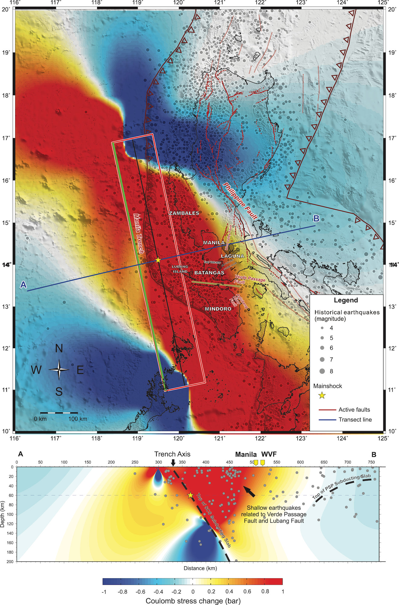
This widely distributed increase in stress could promote rupture along known active faults in the region, including two nearby left-lateral faults (Verde Passage Fault and Lubang Fault), and two nearby right-lateral faults (Aglubang River Fault in Mindoro Island and the West Valley Fault in Metro Manila). Stress would also increase beneath the Macolod Corridor, where the active Taal Volcano resides.
Inexpensive, innovative seismology
Volunteer citizen hosted seismometers recorded the March 14 temblor, including those installed in Visayas, more than 300 kilometers (190 miles) away, and Mindanao in the southern Philippines, more than 900 kilometers away (560 miles). These privately-owned and maintained seismometers are part of a network currently being established by the College of Science of the University of the Philippines-Diliman (UP Diliman) in Quezon City. These low cost-seismometers, developed by Raspberry Shake, have been tried and tested both in the laboratory (Anthony et al., 2019) and in the field (Manconi et al., 2018; Winter et al., 2021; Holmgren, 2021). Similarly, during the magnitude-7.2 Haiti earthquake on August 14, 2021, citizen-science seismometers helped scientists detect and characterize the main earthquake and its aftershocks (Calais, 2022).
For the magnitude-6.4 earthquake that struck in March, the UP Diliman-based network calculated a magnitude of 6.4 and a depth of 11 kilometers, which is consistent with calculations by international seismological observatories such as the U.S. Geological Survey, GEOFON German Research Center for Geosciences (GEOFON-GFZ) and PHIVOLCS, emphasizing the accuracy of the seismometers despite being inexpensive.
At the UP National Institute of Physics (UP-NIP), another low-cost seismic network consisting of accelerometers manufactured by a group of young scientists of the institutes’ Instrumentation Physics Laboratory (ILP) has produced encouraging results after being tested on campus grounds. The accelerometers each cost less than $200 (USD) to manufacture. Most of their components are commercially available and can be purchased online. In the initial testing of this seismic network, the custom-made accelerometers demonstrated a sensitivity sufficiently accurate to detect ground motion generated by a very weak seismic source (i.e., metal plate hit by a hammer).

This capability of detecting weak seismic signals holds promise in the effort to conduct innovative and inexpensive earthquake research geared towards establishing a ground acceleration attenuation relation for local conditions (Aurelio, ongoing). A ground acceleration attenuation relation is a mathematical equation that describes not only how the strength of the seismic waves dissipate as a function of distance to the seismic source, but also how strong the ground would shake as a function of the nature of the subsurface. During an earthquake, areas underlain by sand or silt such as within river valleys and along coastlines shake more strongly than areas located at the same distance but underlain by solid rock. Current attenuation relations used in the Philippines come from experiments conducted outside of the country. Efforts to update these relationships to account for local conditions contribute significantly to building earthquake hazard resilience, especially in a country prone to earthquakes, but where funding for scientific research often takes a back seat.
The accelerometer team includes the following researchers from the UP National Institute of Physics (UP-NIP): Ralen Malatbalat, Emil Joseph Mateo, Alimuddin Arriesgado, Christian Sabile Valgomera, Giovanni Tapang, and from the UP National Institute of Geological Sciences (UP-NIGS): Sandra Donna Catugas, Kristine Joy Taguibao, Chance Isaac Carantes, John Agustin Escudero, Mario Aurelio.
References
Anthony, R.E., Ringler, A., Wilson D.C., and Wolin, E. (2019). Do Low-Cost Seismographs Perform Well Enough for Your Network? An Overview of Laboratory Tests and Field Observations of the OSOP Raspberry Shake 4D. Seismological Research Letters. 90 (1): 219-228.
Aurelio, M. (ongoing). Project Leader: Establishing a ground attenuation relation for the Philippines using artificial blasting methods. Project funded by the University of the Philippines – Office of the Vice-President for Academic Affairs (UP-OVPAA) under the Enhanced Creative Work Research Grant (ECWRG).
Aurelio, M., Catugas, S.D., Escudero, J. A., Lagmay, A.M.F. and Tapang, G., (2021a). Luzon, Philippines, sees sixth strong earthquake in five months, Temblor, doi.org/10.32858/temblor.225
Aurelio, M., Lagmay, M., Escudero, J. A., and Catugas, S. (2021b). Latest Philippine earthquake reveals tectonic complexity, Temblor, doi.org/10.32858/temblor.191
Aurelio, M., Lagmay, M., Escudero, J. A., and Catugas, S. (2021c). Philippine fault jolts Batangas again, with magnitude-5.8 quake, Temblor, doi.org/10.32858/temblor.198
Aurelio, M., Lagmay, M., Escudero, J. A., and Catugas, S. (2021d). Magnitude-5.7 Batangas earthquake puzzles researchers, Temblor, doi.org/10.32858/temblor.21
Calais, E. (2022). Haiti earthquake captured by citizen-seismologists, Temblor, http://doi.org/10.32858/temblor.245
Fukushima, Y. and Tanaka, T. (1990). A New Attenuation Relation for Peak Horizontal Acceleration of Strong Earthquake Ground Motion in Japan, Bull. Seism. Soc. Am., Vol. 80, No. 4, 757-783.
GEOFON German Research Center for Geosciences. Available at: www.geofon.gfz-potsdam.de
Holmgren, J.M and Werner, M. (2021). Raspberry Shake Instruments Provide Initial Ground‐Motion Assessment of the Induced Seismicity at the United Downs Deep Geothermal Power Project in Cornwall, United Kingdom. The Seismic Record 1 (1): 27–34.
Jarvis, A., H.I. Reuter, A. Nelson, E. Guevara (2008). Hole-filled SRTM for the globe Version 4, available from the CGIAR-CSI SRTM 90m Database (http://srtm.csi.cgiar.org).
Kagan, Y.Y. and Jackson, D.D. (2011). Tohoku Earthquake; a surprise? Bulletin of the Seismological Society of America, DOI: 10.1785/0120120110
Lagmay, A., Tarriela, R., Aurelio, M., Ybanez, R., Ybanez, A., Sulapas, J., Baldago, M.C., Sarmiento, D.M., Cabria, H., Rodolfo, R., Rafael, D.J., Trinidad, J.R., Obille, E. and Rosell, N. (2021). Hazardous base surges of Taal’s 2020 eruption. Scientific Reports, 11 (15703). https://doi.org/10.1038/s41598-021-94866-2
Manconi, A., Coviello, V. and Galletti, M. (2018). Short Communication: Monitoring Rockfall with the Raspberry Shake. Earth Surface Dynamics 6(4): 1219-1227.
Observatoire GEOSCOPE. Available at: http://geoscope.ipgp.fr/index.php/en/
Philippine Institute of Volcanology and Seismology (PHIVOLCS). Available at: www.phivolcs.dost.gov.ph
Stein, S. and Okal, E. (2011). The size of the 2011 Tohoku earthquake needn’t have been a surprise. EOS Transactions, DOI: 10.1029/2011EO270005
Toda, S., Stein, R. (2022). ‘Triplet’ earthquakes strike near Tohoku, Japan, but a rupture gap remains, Temblor, http://doi.org/10.32858/temblor.246
Toda, S., Stein, R.S., Sevilgen, V. and Lin, J. (2011). Coulomb 3.3 Graphic-rich deformation and stress-change software for earthquake, tectonic, and volcano research and teaching—user guide: U.S. Geological Survey Open-File Report 2011–1060, 63 p., available at https://pubs.usgs.gov/of/2011/1060/
United States Geological Survey – National Earthquake Information Center (USGS-NEIC). Available at: www.earthquake.usgs.gov
Weatherall, P., Tozer, B., Arndt, J.E., Bazhenova, E., Bringensparr, C., Castro, C.F., Dorschel, B., Ferrini, V., Hehemann, L., Jakobsson, M., Johnson, P., Ketter, T., Mackay, K., Martin, T.V., Mayer, L.A., McMichael-Phillips, J., Mohammad, R., Nitsche, F.O., Sandwell, D.T., Snaith, H., Viquerat, S. (2020). The GEBCO_2020 Grid – a continuous terrain model of the global oceans and land. British Oceanographic Data Centre, National Oceanography Centre, NERC, UK. doi:10.5285/a29c5465-b138-234d-e053-6c86abc040b9
Wells, D. and Coppersmith, K. (1994). New Empirical Relationships among Magnitude, Rupture Length, Rupture Width, Rupture Area, and Surface Displacement. Bulletin of the Seismological Society of America. 84. 974-1002.
Wessel, P. and Smith, W.H.F., (1995). New version of the Generic Mapping Tools released. EOS Trans. Am. Geophys. Union 76, 329.
Winter, K., Lombardi, D. Diaz-Moreno A., and Bainbridge, R. (2021). Monitoring Icequakes in East Antarctica with the Raspberry Shake. Seismological Research Letters. Doi: https://doi.org/10.1785/0220200483
- Venezuela’s doublet leaned toward Caracas - June 30, 2026
- Is Southern California’s Cajon Pass an ‘earthquake gate’ ready to open? - June 29, 2026
- Philippines magnitude 7.8 shock may have loaded the central Cotabato subduction zone - June 11, 2026