Is this an unusually productive aftershock sequence, or could these quakes prove to be foreshocks of a larger event that has yet to strike?
By Mario Aurelio, Director of the University of the Philippines National Institute of Geological Sciences, Sandra Donna Catugas, Structural Geology and Tectonics Laboratory at the University of Philippines National Institute of Geological Sciences, John Agustin Escudero, Structural Geology and Tectonics Laboratory at the University of Philippines National Institute of Geological Sciences, Alfredo Mahar Francisco Lagmay, Executive Director, University of the Philippines Resilience Institute-Nationwide Operational Assessment of Hazards Center (@nababaha), Giovanni A. Tapang, Dean of the University of the Philippines-Diliman, College of Science
Citation: Aurelio, M., Catugas, S.D., Escudero, J. A., Lagmay, A.F.M. and Tapang, G., 2021, Luzon, Philippines, sees sixth strong earthquake in five months, Temblor, http://doi.org/10.32858/temblor.225
On December 13, 2021, at 5:12 p.m. local time, the Batangas region in southern Luzon, Philippines, was hit by the fifth earthquake with a magnitude greater than 5.0 since a magnitude-6.6 tremor on July 24, 2021 (Aurelio et al., 2021a; 2021b; 2021c). Prior to this, four earthquakes with magnitude-5.8 (July 24 and August 13), 5.7 (September 27) and 5.2 (October 7) struck within a radius of 20 miles (30 kilometers) of the first July 24 event. This recurrence interval — an average of more than one strong earthquake every month — is too short to be neglected. This is either an unusually vigorous aftershock sequence, or an event comparable to a seismic swarm.
Area of stress increase
Using the fault responsible for generating the magnitude-6.6 earthquake of July 24, as the source fault, Coulomb stress transfer modeling indicates that the magnitude-5.5 tremor of December 13 falls within the lobe of increased stress when used as the receiver fault (Fig. 1). The 65-mile (104-kilometer) depth of the December tremor also plots approximately along the same fault plane, but four miles (seven kilometers) shallower than the July 24 event. These observations suggest that the first earthquake likely triggered the second.

The same triggering mechanism can explain three of the other recent magnitude-5.0 and larger events when each is used as the receiver fault (Aurelio et al., 2021a; 2021b), except for the magnitude-5.7 quake of September 27, which occurred in a zone of decreased stress (Aurelio et al., 2021c).
However, when Coulomb stress transfer modeling considers an optimally-oriented receiver fault — assumed to be aligned with the stress field, thus promoting failure — all five earthquakes that succeeded the July 24 magnitude-6.6 earthquake fall within the lobe of increased stress at 65 miles (104 kilometers) depth (Fig. 2). The hypocenters — the locations on the fault where each earthquake nucleated — cluster within the calculated region of increased stress, which suggests triggering of all five quakes by the magnitude-6.6 July 24 event.

Cause for concern?
Based on the data collected during the last decade (Aurelio et al., 2021b), an average of 2.5 events larger than magnitude-5.0 strike per year within 50 kilometers of the July 24 magnitude-6.6 event. The recent spate of moderate quakes — each separated by less than a month — far exceeds this average and suggests that this is an evolving sequence.
Could these six moderate magnitude earthquakes occurring over a short period of time indicate that stresses are being released rapidly? Or could these be lower-magnitude foreshocks of a larger event that has yet to strike? The latter is a possibility and should serve as a reminder to the 25 million inhabitants of Metro Manila and surrounding provinces that this region is vulnerable to a large earthquake. Preparedness and readiness are vital.
Low-cost seismology studies
The December 13 tremor was recorded by low-cost seismometers partly belonging to Public Seismic Network that is currently being established by the College of Science of the University of the Philippines-Diliman (UP Diliman) in Quezon City (Fig. 3). These low-cost seismometers, developed by Raspberry Shake, have been tried and tested both in the laboratory (Anthony et al., 2019) and in the field (Manconi et al., 2018; Winter et al., 2021; Holmgren, 2021).

The earthquake parameters for December’s quake, generated by the UP Diliman-based network, include a calculated magnitude of 5.5, which compares well with magnitudes calculated by established international seismological observatories such as the U.S. Geological Survey – National Earthquake Information Center (USGS-NEIC), GEOFON German Research Center for Geosciences (GEOFON-GFZ, Potsdam, Germany) and PHIVOLCS (Philippines). The low-cost, Raspberry Shake-derived earthquake depth of 98 miles (157 kilometers) is close to that computed by USGS-NEIC, but varies significantly from GEOFON-GFZ (69 miles/111 kilometers) and PHIVOLCS (64 miles/104 kilometers) estimates.
Currently, most of these low-cost seismometers are owned and operated by ordinary citizens on their private properties. Though the stations are still scarce, there are good indications that more citizens are interested in setting up their own stations to join the UP Diliman-based network. Efforts are underway to find funds for more seismometers to deploy in schools throughout the country, with the aims of expanding the network and serving as a learning and teaching platform for students interested in earthquake studies.
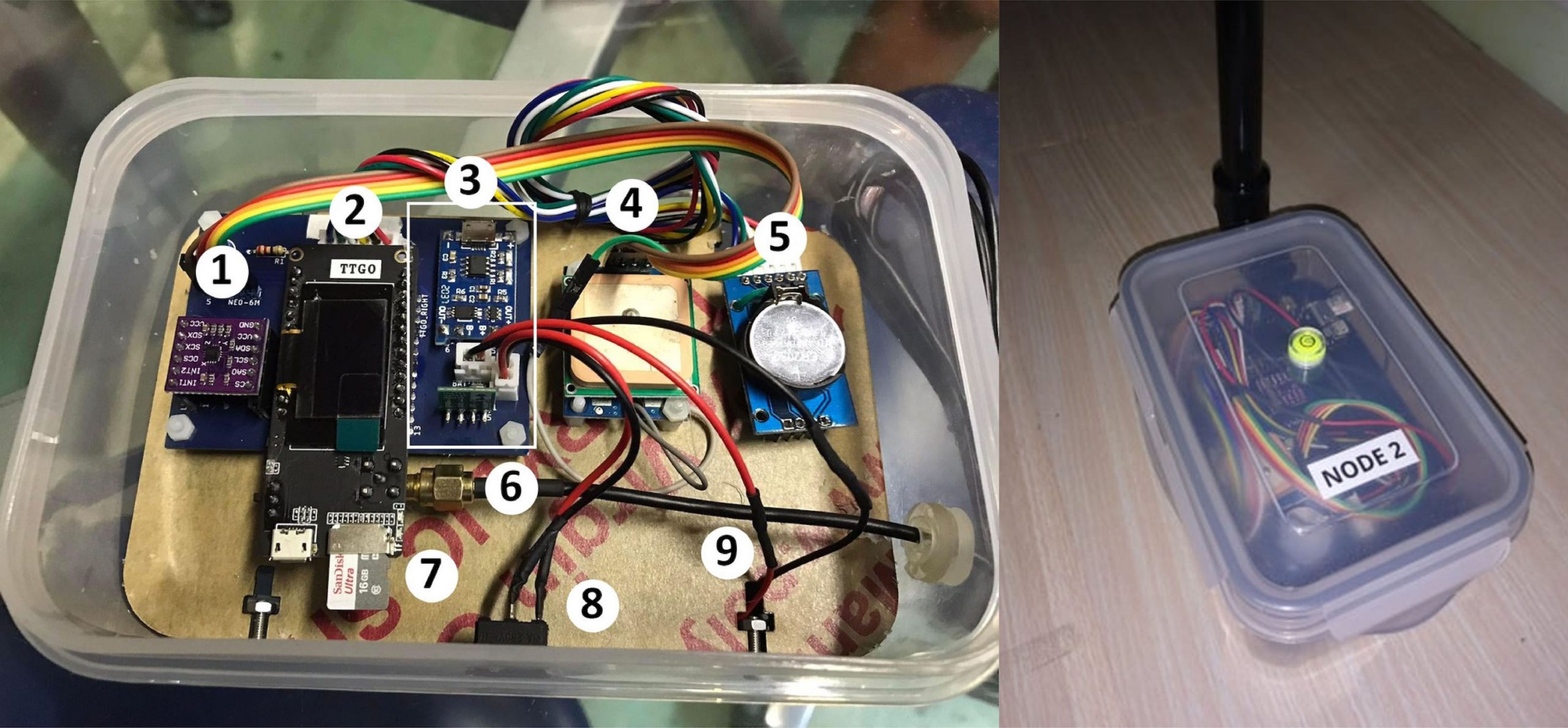
Meanwhile, at the UP National Institute of Physics (UP-NIP), a group of scientists from the institutes’ Instrumentation Physics Laboratory (ILP), is developing a low-cost seismic network consisting of accelerometers manufactured from commercially available components (Fig. 4). Each accelerometer costs less than $200 USD to manufacture. This network is part of a study to understand how shaking decays with distance from the source and how it is influenced by the nature of the ground underneath — called a ground attenuation relationship. Current attenuation relationships used in the country come from outside the Philippines, including experimental results from artificially induced, low-magnitude earthquakes, and data gathered directly from natural earthquakes.
These complementary efforts to establish low-cost seismological observatories serve two purposes. The Raspberry Shake network promotes citizen science. The second effort led by scientists helps Philippine researchers conduct innovative but inexpensive earthquake research. Both efforts hold promise in contributing to hazard resilience in an earthquake-prone country that often lacks scientific research funds.
References
Anthony, R.E., Ringler, A., Wilson D.C., and Wolin, E. (2019). Do Low-Cost Seismographs Perform Well Enough for Your Network? An Overview of Laboratory Tests and Field Observations of the OSOP Raspberry Shake 4D. Seismological Research Letters. 90 (1): 219-228.
Aurelio, M. (ongoing). Project Leader: Establishing a ground attenuation relation for the Philippines using artificial blasting methods. Project funded by the University of the Philippines – Office of the Vice-President for Academic Affairs (UP-OVPAA) under the Enhanced Creative Work Research Grant (ECWRG).
Aurelio, M., Lagmay, M., Escudero, J. A., and Catugas, S. (2021a). Latest Philippine earthquake reveals tectonic complexity, Temblor, doi.org/10.32858/temblor.191
Aurelio, M., Lagmay, M., Escudero, J. A., and Catugas, S. (2021b). Philippine fault jolts Batangas again, with magnitude-5.8 quake, Temblor, doi.org/10.32858/temblor.198
Aurelio, M., Lagmay, M., Escudero, J. A., and Catugas, S. (2021c). Magnitude-5.7 Batangas earthquake puzzles researchers, Temblor, doi.org/10.32858/temblor.21
GEOFON German Research Center for Geosciences. Available at: www.geofon.gfz-potsdam.de
Holmgren, J.M and Werner, M. (2021). Raspberry Shake Instruments Provide Initial Ground‐Motion Assessment of the Induced Seismicity at the United Downs Deep Geothermal Power Project in Cornwall, United Kingdom. The Seismic Record 1 (1): 27–34.
Jarvis, A., H.I. Reuter, A. Nelson, E. Guevara (2008). Hole-filled SRTM for the globe Version 4, available from the CGIAR-CSI SRTM 90m Database (http://srtm.csi.cgiar.org).
Manconi, A., Coviello, V. and Galletti, M. (2018). Short Communication: Monitoring Rockfall with the Raspberry Shake. Earth Surface Dynamics 6(4): 1219-1227.
Observatoire GEOSCOPE. Available at: http://geoscope.ipgp.fr/index.php/en/
Philippine Institute of Volcanology and Seismology (PHIVOLCS). Available at: www.phivolcs.dost.gov.ph
Toda, Shinji, Stein, R.S., Sevilgen, Volkan, and Lin, J. (2011). Coulomb 3.3 Graphic-rich deformation and stress-change software for earthquake, tectonic, and volcano research and teaching—user guide: U.S. Geological Survey Open-File Report 2011–1060, 63 p., available at https://pubs.usgs.gov/of/2011/1060/
United States Geological Survey – National Earthquake Information Center (USGS-NEIC). Available at: www.earthquake.usgs.gov
Weatherall P., Tozer B., Arndt J.E., Bazhenova E., Bringensparr C., Castro C.F., Dorschel B., Ferrini V., Hehemann L., Jakobsson M., Johnson P., Ketter T., Mackay K., Martin T.V., Mayer L.A., McMichael-Phillips J., Mohammad R., Nitsche F.O., Sandwell D.T., Snaith H., Viquerat S. (2020). The GEBCO_2020 Grid – a continuous terrain model of the global oceans and land. British Oceanographic Data Centre, National Oceanography Centre, NERC, UK. doi:10.5285/a29c5465-b138-234d-e053-6c86abc040b9
Wessel, P. and Smith, W.H.F., (1995). New version of the Generic Mapping Tools released. EOS Trans. Am. Geophys. Union 76, 329.
Winter, K., Lombardi, D. Diaz-Moreno A., and Bainbridge, R. (2021). Monitoring Icequakes in East Antarctica with the Raspberry Shake. Seismological Research Letters. Doi: https://doi.org/10.1785/0220200483
- Venezuela’s doublet leaned toward Caracas - June 30, 2026
- Is Southern California’s Cajon Pass an ‘earthquake gate’ ready to open? - June 29, 2026
- Philippines magnitude 7.8 shock may have loaded the central Cotabato subduction zone - June 11, 2026