The magnitude-6.6 earthquake that struck Luzon, Philippines, on July 24 showcases the benefits of citizen science and serves as a wakeup call.
Editor’s note: This article was updated on July 28 to include several additional earthquakes in the table and in the text.
By Mario Aurelio, Director of the University of the Philippines National Institute of Geological Sciences, Mahar Lagmay, Executive Director, University of the Philippines Resilience Institute-Nationwide Operational Assessment of Hazards Center (@nababaha), John Agustin Escudero, Structural Geology and Tectonics Laboratory at the University of Philippines National Institute of Geological Sciences, Sandra Catugas, Structural Geology and Tectonics Laboratory at the University of Philippines National Institute of Geological Sciences
Citation: Aurelio, M., Lagmay, M., Escudero, J. A., and Catugas, S., 2021, Latest Philippine earthquake reveals tectonic complexity, Temblor, http://doi.org/10.32858/temblor.191
A magnitude-6.6 earthquake struck the island of Luzon, Philippines, at 4:47 a.m. local time on Saturday, July 24 (data from the Philippine Institute of Volcanology and Seismology, or PHIVOLCS). The epicenter was located off the coast of the Calatagan Peninsula in the province of Batangas, some 100 kilometers southwest of the capital city of Manila. About 10 minutes later, a magnitude-5.7 aftershock occurred in approximately the same location. As expected, aftershocks have continued to rock the region. Damages were minimal, though the region is currently besieged by torrential rains from seasonal monsoons and typhoons, which are causing floods and landslides.
The Calatagan earthquake is not the first in this area, nor will it be the last. The tectonic complexity of the region where the July 24 quake struck explains the high frequency of seismic events in this area. Given that the region is home to densely populated urban centers, the coexistence of several earthquake-generating systems (subduction zones, strike-slip faults, extensional systems) and nearby active volcanic centers highlights the importance of understating each individual phenomenon, as well as as the interplay and interaction among them.
Complex tectonic setting
The Philippines and surrounding region not only involves six active subduction zones, but also other seismically active structures, including strike-slip faults, extensional systems and active volcanic centers like the nearby Taal Volcano. Because of the complex setting, earthquakes often mask each other, rendering it challenging to determine the earthquakes’ sources.

These trenches, together with numerous active faults within the Philippine Mobile Belt, help accommodate the oblique convergence between the Philippine Sea Plate and the eastern margin of the Eurasian Plate at a rate that varies from about 3.6 centimeters per year in Taiwan to about 8.2 centimeters per year in the southern Philippines (e.g., Seno, 1977). Subduction along Manila Trench may be as fast as 5.0 centimeters per year (e.g., Rangin et al., 1999).
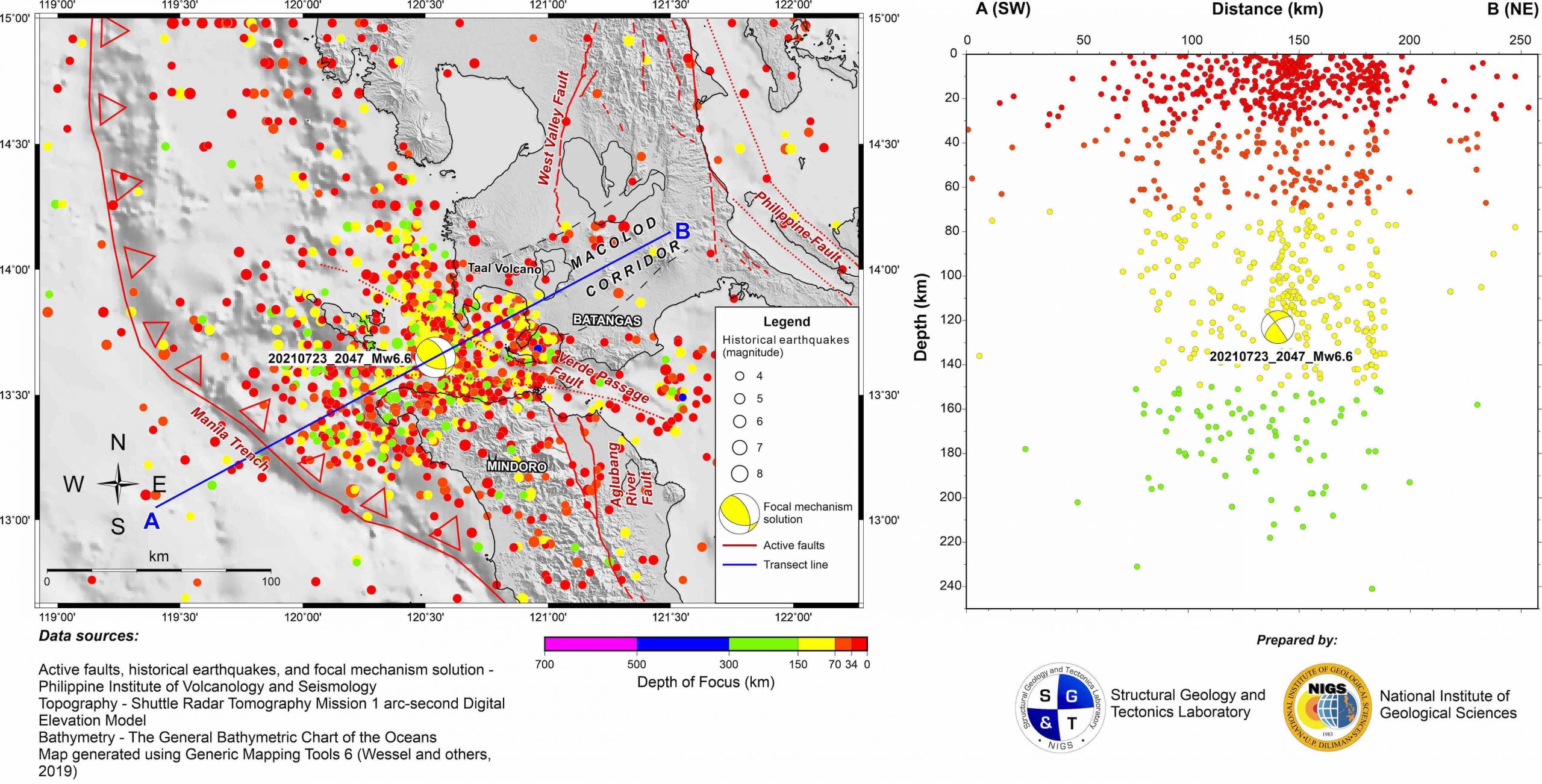
The subducting slab along the Manila Trench at the latitude where the Calatagan earthquake struck dips very steeply — nearly vertically — as shown by the trace of the corresponding Wadatti-Benioff zone (Figure 2). The depth at which the earthquake nucleated, as reported by several seismological observatories (including PHIVOLCS, USGS-NEIC and GEOFON) ranges from 112 to 130 kilometers. Focal mechanism solutions calculated by these observatories consistently indicate that the quake occurred on one of a pair of nearly parallel thrust faults striking northwest. This north-westerly fault pair orientation is consistent with the geometry of subduction along Manila Trench at this latitude.
Coulomb stress transfer
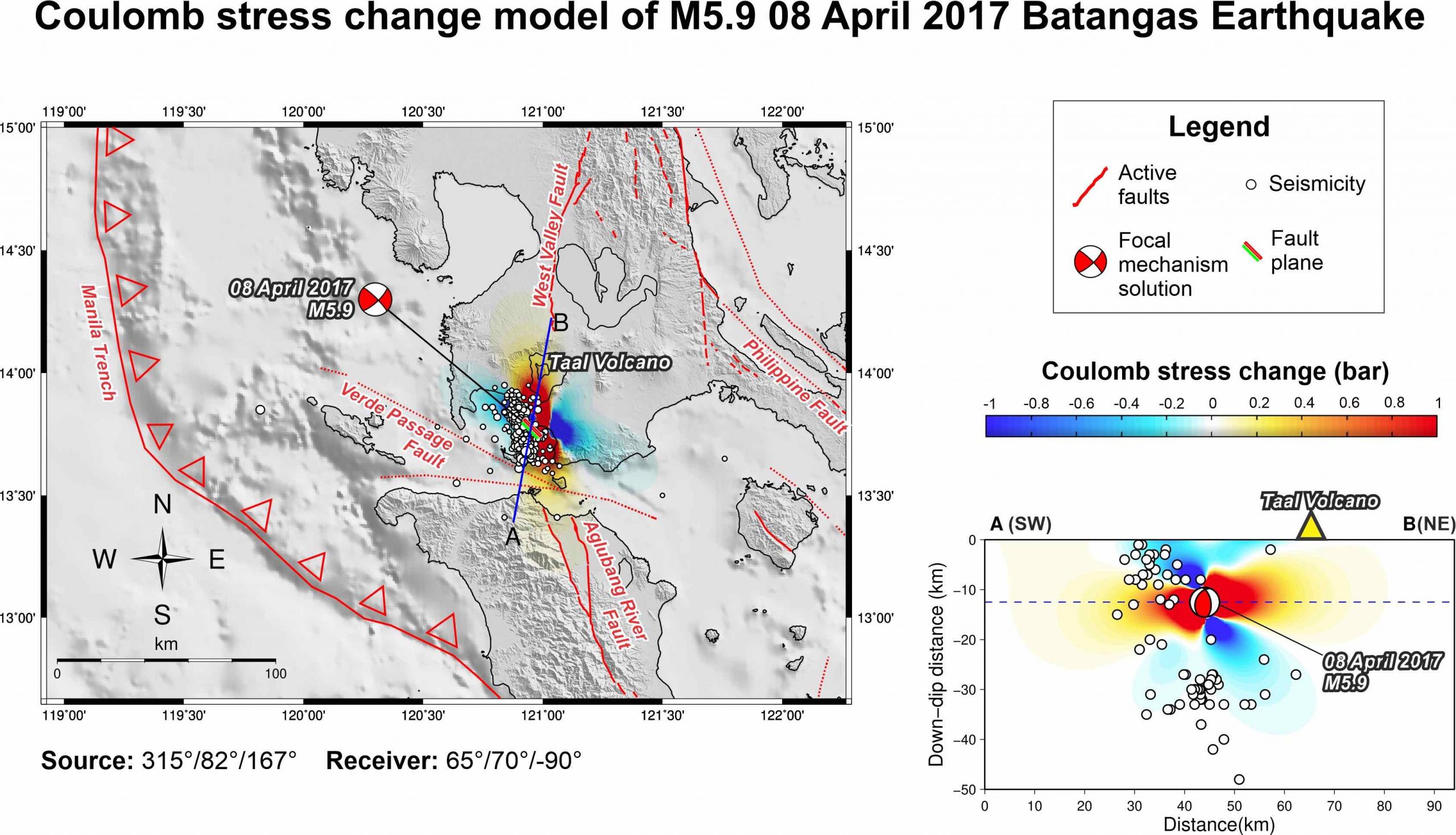
Between April 4 and 8, 2017, a series of moderate-magnitude, shallow-focus earthquakes, including a magnitude-5.9 (8 kilometers depth) struck Mabini Peninsula, located about 20 kilometers east of Calatagan Peninsula. On August 11, a larger magnitude-6.3 (177 kilometer depth) quake struck the same region. Coulomb stress transfer modeling of the April 8 event suggests that this earthquake sequence transferred a significant amount of stress toward Taal Volcano (Figure 3), which could have contributed to initiating a major eruption of the volcano three years later in January 2020, and succeeding minor eruptive events in recent weeks (including early July 2021).
Citizen science
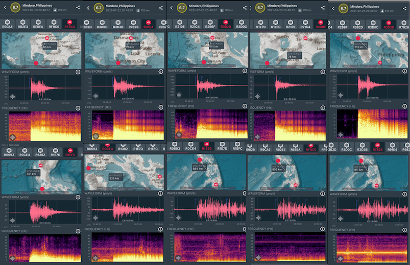
The July 24 magnitude-6.6 Calatagan earthquake and aftershocks were detected by privately owned low-cost seismometers from as far as North Luzon in Baguio (about 300 kilometers away), to the southern portion of the Philippines in Davao, Mindanao (Figure 4) (about 900 kilometers away). The records generated by citizen scientists were consistent with the results of the government-owned Philippine Seismic Network operated by the PHIVOLCS.
These low-cost seismometers, developed by Raspberry Shake, have been tried and tested both in the laboratory (Anthony et al., 2019) and in the field (Manconi et al., 2018; Winter et al., 2021; Holmgren, 2021), showing their potential for increasing the density of the government seismic network.
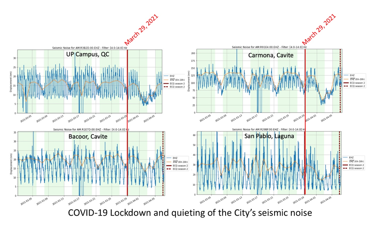
The Raspberry Shake seismometers were even used to monitor quiescence of the ground (Lecocq et al., 2020) in various cities of Luzon Island due to Covid-19 lockdowns (Figure 5). These citizen science seismometers have immense value in earthquake education and research (Bent, 2018; Subedi, 2020), considering that earthquakes pose a serious threat to Philippine communities.
A wakeup call
The Calatagan earthquake is another wakeup call in the chain of destructive earthquakes that has recently plagued the Philippines (Table 1). On Christmas Day of 2020, a deep-seated (more than 100 kilometer deep) magnitude-6.3 earthquake rocked Batangas near where the Calatagan 2021 earthquake struck. On August 18 earlier that year, Masbate Island in the central Philippines was devastated by a magnitude-6.6 tremor causing extensive damage to infrastructure in Cataingan town (Aurelio, 2020). In 2019, a series of four magnitude-5.9 to -6.6 shallow-focus earthquakes devastated North Cotabato, killing 23 people (with 11 still missing) and injuring 563 people (NDRRMC, 2019). Earlier in the year, a magnitude-6.1 earthquake (epicenter in Zambales) rocked Central Luzon, leaving 18 dead, 3 people missing and 256 injured (NDRRMC, 2019). Shaking from Zambales earthquake was felt 100 kilometers away in Manila. In 2017, the earthquake sequence that struck Batangas province in April and August fortunately did not result in any fatalities, only injuring a few and causing 18 million pesos worth of damages to property. Like the 2017 Batangas earthquakes, the 2021 Calatagan earthquake in Batangas had no casualties. This may not be the case the next time a big one strikes.

Prevention, mitigation and preparedness
For a country with a long history of destructive seismicity, the Calatagan earthquake again highlights the need to prepare against the constant threat of natural hazards. The increasing number of amateur seismologists and enthusiasts using low-cost seismometers in the country is most welcome.
The National Institute of Geological Sciences and the College of Science of the University of the Philippines have embarked on a program to magnify the efforts of citizen scientists consistent with the Sendai Framework for Disaster Risk Reduction guiding principles of a whole-of-society and science-based approach to disaster risk reduction. The program involves the promotion of earthquake education and research, hopefully to increase disaster awareness of the populace and sharpen understanding of Philippine tectonics and earthquakes.
References
Anthony, R.E., Ringler, A., Wilson D.C., and Wolin, E. (2019). Do Low-Cost Seismographs Perform Well Enough for Your Network? An Overview of Laboratory Tests and Field Observations of the OSOP Raspberry Shake 4D. Seismological Research Letters. 90 (1): 219-228.
Aurelio, M.A. (2000). Tectonics of the Philippines revisited. Journal of the Geological Society of the Philippines. 55, 3/4, 119-183.
Aurelio, M.A., Peña, R.E., and Taguibao, K.J.L. (2013). Sculpting the Philippine archipelago since the Cretaceous through rifting, oceanic spreading, subduction, obduction, collision and strike-slip faulting: Contribution to IGMA5000. Journal of Asian Earth Sciences, 7, 102-107 http://dx.doi.org/10.1016/j.jseaes.2012.10.007
Aurelio, M.A., (2020). Masbate Earthquake: They saw it coming. https://newsinfo.inquirer.net/1327565/masbate-earthquake-they-saw-it-coming
Bautista M.L.P., Bautista B.C., Narag I.C., Atando R.A. and Relota E.P. (2011). “The 1948 (Ms 8.2) Lady Caycay Earthquake and Tsunami and Its Possible Socio-economic Impact to Western Visayan Communities in the Philippines”. Proceedings of the Ninth Pacific Conference on Earthquake Engineering Auckland, New Zealand.
Bent, A.L., Cassidy, J., Prépetit, C., Lamontagne, M., and Sophia Ulysse, S. (2018). Real‐Time Seismic Monitoring in Haiti and Some Applications. Seismological Research Letters (2018) 89 (2A): 407–415.
Evening Independent (1949). “Luzon Island Shaken by Major Earthquake.” Retrieved July 24, 2021. https://news.google.com/newspapers?id=U2hIAAAAIBAJ&pg=3907,2009367&dq=luzon+earthquake&hl=en
GEOFON German Research Center for Geosciences. Available at: www.geofon.gfz-potsdam.de
Holmgren, J.M and Werner, M. (2021). Raspberry Shake Instruments Provide Initial Ground‐Motion Assessment of the Induced Seismicity at the United Downs Deep Geothermal Power Project in Cornwall, United Kingdom. The Seismic Record 1 (1): 27–34.
Lecocq, T. et al., (2020). Global quieting of high-frequency seismic noise due to COVID-19 pandemic lockdown measures. Science. 369 (6509) 1338-1343.
Manconi, A., Coviello, V. and Galletti, M. (2018). Short Communication: Monitoring Rockfall with the Raspberry Shake. Earth Surface Dynamics 6(4): 1219-1227.
Philippine Institute of Volcanology and Seismology (PHIVOLCS). Available at: www.phivolcs.dost.gov.ph
Rangin, C., Le Pichon, X., Mazzotti, S., Pubellier, M., Chamot-Rooke, N., Aurelio, M., Walpersdorf, A. and Quebral, C. (1999). Plate convergences measured by GPS across the Sundaland/Philippine Sea Plate deformed boundary: the Philippines and eastern Indonesia. Geophysical Journal International, 139, 296-316.
National Disaster Risk Reduction Management Council – DRRMC (2019). SitRep No.39 re Magnitude 6.6 and 6.5 Earthquakes in Tulunan North Cotabato
National Disaster Risk Reduction Management Council – DRRMC (2017) Sitrep No. 15 re Magnitude 6.1 Earthquake in Castillejos, Zambales
Seno, T. (1977). The instantaneous rotation vector of the Philippine Sea Plate in relation to the Eurasian Plate. Tectonophysics, 42, 209-226.
Subedi, S., Hetényi, G, Denton, P., and Sauron, A. (2020). Seismology at School in Nepal: A Program for Educational and Citizen Seismology Through a Low-Cost Seismic Network. Frontiers in Earth Science. 8(73), 1-19.
Toda, Shinji, Stein, R.S., Sevilgen, Volkan, and Lin, J. (2011). Coulomb 3.3 Graphic-rich deformation and stress-change software for earthquake, tectonic, and volcano research and teaching—user guide: U.S. Geological Survey Open-File Report 2011–1060, 63 p., available at https://pubs.usgs.gov/of/2011/1060/
United States Geological Survey – National Earthquake Information Center (USGS-NEIC). Available at: www.earthquake.usgs.gov
Wessel, P. and Smith, W.H.F., (1995). New version of the Generic Mapping Tools released. EOS Trans. Am. Geophys. Union 76, 329.
Winter, K., Lombardi, D. Diaz-Moreno A., and Bainbridge, R. (2021). Monitoring Icequakes in East Antarctica with the Raspberry Shake. Seismological Research Letters. Doi: https://doi.org/10.1785/0220200483
- Venezuela’s doublet leaned toward Caracas - June 30, 2026
- Is Southern California’s Cajon Pass an ‘earthquake gate’ ready to open? - June 29, 2026
- Philippines magnitude 7.8 shock may have loaded the central Cotabato subduction zone - June 11, 2026