Monday’s tremor, the third moderate earthquake in nine weeks, occurred where stress had decreased after a strong earthquake in July. Researchers want to know why.
By Mario Aurelio, Director of the University of the Philippines National Institute of Geological Sciences, Alfredo Mahar Francisco Lagmay, Executive Director, University of the Philippines Resilience Institute-Nationwide Operational Assessment of Hazards Center (@nababaha), John Agustin Escudero, Structural Geology and Tectonics Laboratory at the University of Philippines National Institute of Geological Sciences, Sandra Donna Catugas, Structural Geology and Tectonics Laboratory at the University of Philippines National Institute of Geological Sciences
Citation: Aurelio, M., Lagmay, A.F.M., Escudero, J. A., and Catugas, S.D., 2021, TK, Temblor, http://doi.org/10.32858/temblor.211
At 1:12 Monday morning (local time), a magnitude-5.7 earthquake struck offshore of Batangas, Philippines. The shock was followed 28 minutes later by a magnitude-4.5 aftershock.
The earthquake bulletin issued by the Philippine Institute of Volcanology and Seismology (PHIVOLCS) cited that infrastructure damage was expected. Residents in the provinces of Mindoro, Batangas, Laguna, Cavite, and even the capital Manila, 50 miles (80 kilometers) away, felt shaking (intensity III-V on PHIVOLCS intensity scale). Structures, especially high-rise residential and commercial complexes, swayed significantly in Tagaytay City in the province of Cavite and in Metro Manila, alarming occupants.
The event comes nine weeks after a magnitude-6.6 tremor jolted Batangas on July 24, 2021. Three weeks later, a magnitude-5.8 event struck the same region. These earthquakes are associated with complex fault movement along the Manila Trench
Over the last 10 years, an average of 2.5 events larger than magnitude-5.0 strike per year within 30 miles (50 kilometers) of the July 24 event (Aurelio et al., 2021b). The recent spate of moderate quakes far exceeds this average and suggests this is an evolving sequence.
Stress changes after large earthquakes
Similar to the July and August earthquakes, the location, focal mechanism and depth of this most recent seismic event are all consistent with subduction-related fault movement near the Manila Trench. Here, the South China Sea plate dives beneath the Philippine Mobile Belt, a zone of active deformation defining the boundary between the Philippine Sea Plate and the Sunda Plate.
The magnitude-6.6 earthquake in July likely transferred stress to the area where the magnitude-5.8 quake would later strike in August. Interestingly, Monday’s event occurred in an area where Coulomb stress change modelling (Toda et al., 2011) had predicted that stresses had decreased (blue area in Figure 1) as a result of the magnitude-6.6 event.
The magnitude-6.6 event was followed by a magnitude-5.8 aftershock less than 10 minutes later. Coulomb stress transfer modeling indicates that the magnitude-5.8 aftershock and the magnitude-5.8 earthquake on August 13 both fall within the increased stress lobe of the magnitude-6.6 event (Figure 1). This suggests that these two magnitude-5.8 earthquakes were promoted, or triggered, by the magnitude-6.6 mainshock. In that sense, they can be considered aftershocks.
However, it is unusual for more than one aftershock to be less than one magnitude unit smaller than the mainshock. It is also possible that these two magnitude-5.8 earthquakes were independent of both one another and the magnitude-6.6 in July, and would have struck regardless of nearby seismicity.
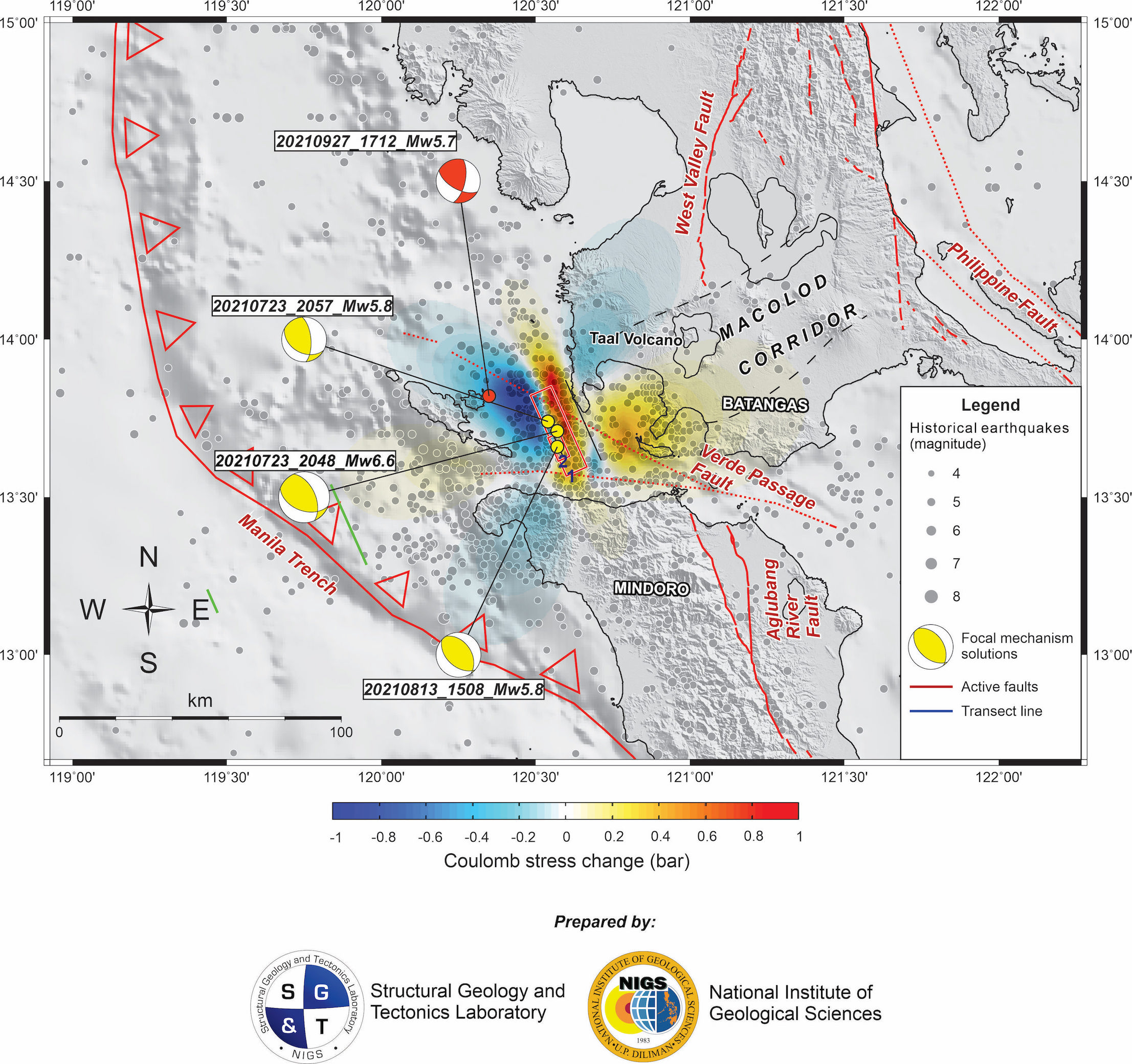
Monday’s magnitude-5.7 event was produced by the rupture of a segment of the subducting slab where movement is least expected, based on the Coulomb stress change model using the magnitude-6.6 earthquake of July 24, 2021 as source fault (Aurelio et al., 2021b). The main shock of the September 27 event was succeeded 28 minutes later, by its own aftershock of less than one magnitude unit smaller at magnitude-4.5, further strengthening the argument that this earthquake could well be independently generated and not an aftershock of the previous earthquakes.
Low-cost Seismology
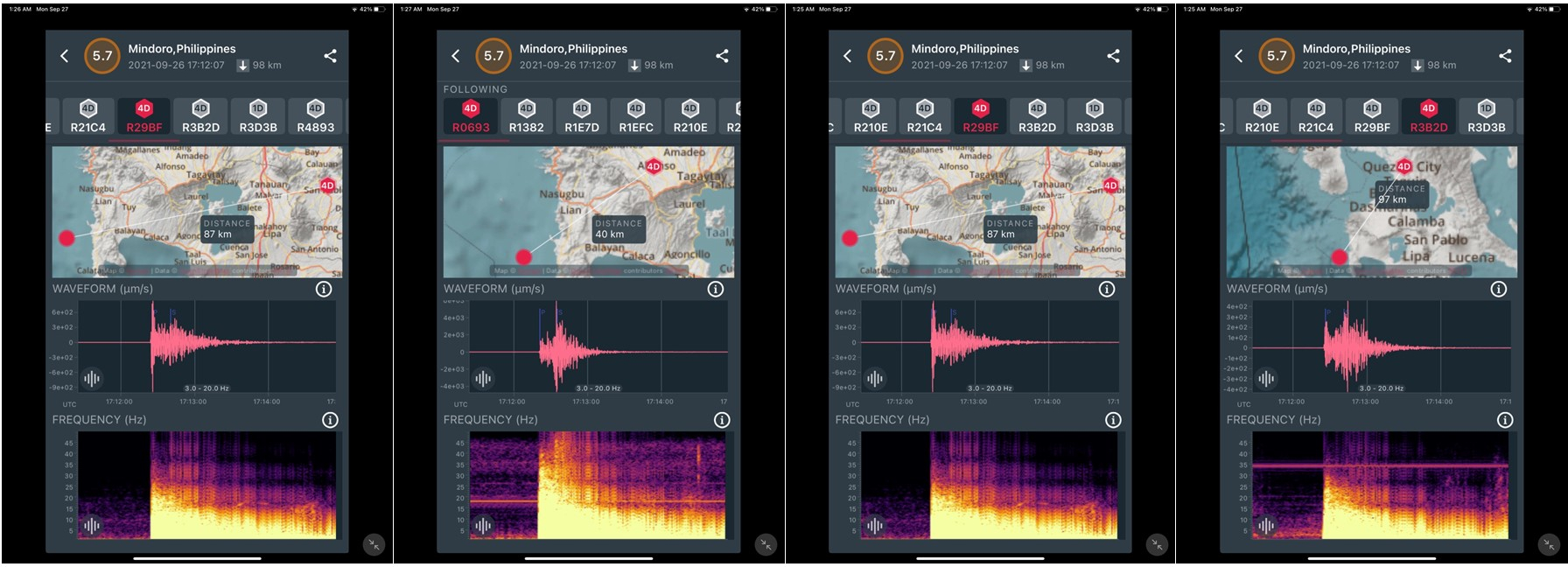
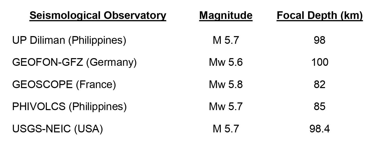
Monday’s tremor was also recorded by low-cost Raspberry Shake seismometers that are part of a network being developed by the University of the Philippines-Diliman (UP Diliman) in Quezon City (Figure 2). Citizens operate these privately-owned sensors on their own properties and share data with scientists. Although there are few seismometers currently in the network, the earthquake parameters calculated from these units are similar to those determined by established international seismological observatories (Table 1).
These data suggest these privately-owned and maintained low-cost seismometers can supplement existing state-owned networks and provide reliable data. Such a citizen science approach to studying earthquakes fosters community engagement and empowers communities to build resilience.
References
Aurelio, M., Lagmay, M., Escudero, J. A., and Catugas, S. (2021a). Latest Philippine earthquake reveals tectonic complexity, Temblor, doi.org/10.32858/temblor.191
Aurelio, M., Lagmay, M., Escudero, J. A., and Catugas, S. (2021b). Philippine fault jolts Batangas again, with magnitude-5.8 quake, Temblor, doi.org/10.32858/temblor.198
GEOFON German Research Center for Geosciences. Available at: www.geofon.gfz-potsdam.de
Jarvis, A., H.I. Reuter, A. Nelson, E. Guevara (2008). Hole-filled SRTM for the globe Version 4, available from the CGIAR-CSI SRTM 90m Database (http://srtm.csi.cgiar.org).
Observatoire GEOSCOPE. Available at: http://geoscope.ipgp.fr/index.php/en/
Philippine Institute of Volcanology and Seismology (PHIVOLCS). Available at: www.phivolcs.dost.gov.ph
Toda, Shinji, Stein, R.S., Sevilgen, Volkan, and Lin, J. (2011). Coulomb 3.3 Graphic-rich deformation and stress-change software for earthquake, tectonic, and volcano research and teaching—user guide: U.S. Geological Survey Open-File Report 2011–1060, 63 p., available at https://pubs.usgs.gov/of/2011/1060/
United States Geological Survey – National Earthquake Information Center (USGS-NEIC). Available at: www.earthquake.usgs.gov
Weatherall P., Tozer B., Arndt J.E., Bazhenova E., Bringensparr C., Castro C.F., Dorschel B., Ferrini V., Hehemann L., Jakobsson M., Johnson P., Ketter T., Mackay K., Martin T.V., Mayer L.A., McMichael-Phillips J., Mohammad R., Nitsche F.O., Sandwell D.T., Snaith H., Viquerat S. (2020). The GEBCO_2020 Grid – a continuous terrain model of the global oceans and land. British Oceanographic Data Centre, National Oceanography Centre, NERC, UK. doi:10.5285/a29c5465-b138-234d-e053-6c86abc040b9
Wessel, P. and Smith, W.H.F., (1995). New version of the Generic Mapping Tools released. EOS Trans. Am. Geophys. Union 76, 329.
- Venezuela’s doublet leaned toward Caracas - June 30, 2026
- Is Southern California’s Cajon Pass an ‘earthquake gate’ ready to open? - June 29, 2026
- Philippines magnitude 7.8 shock may have loaded the central Cotabato subduction zone - June 11, 2026