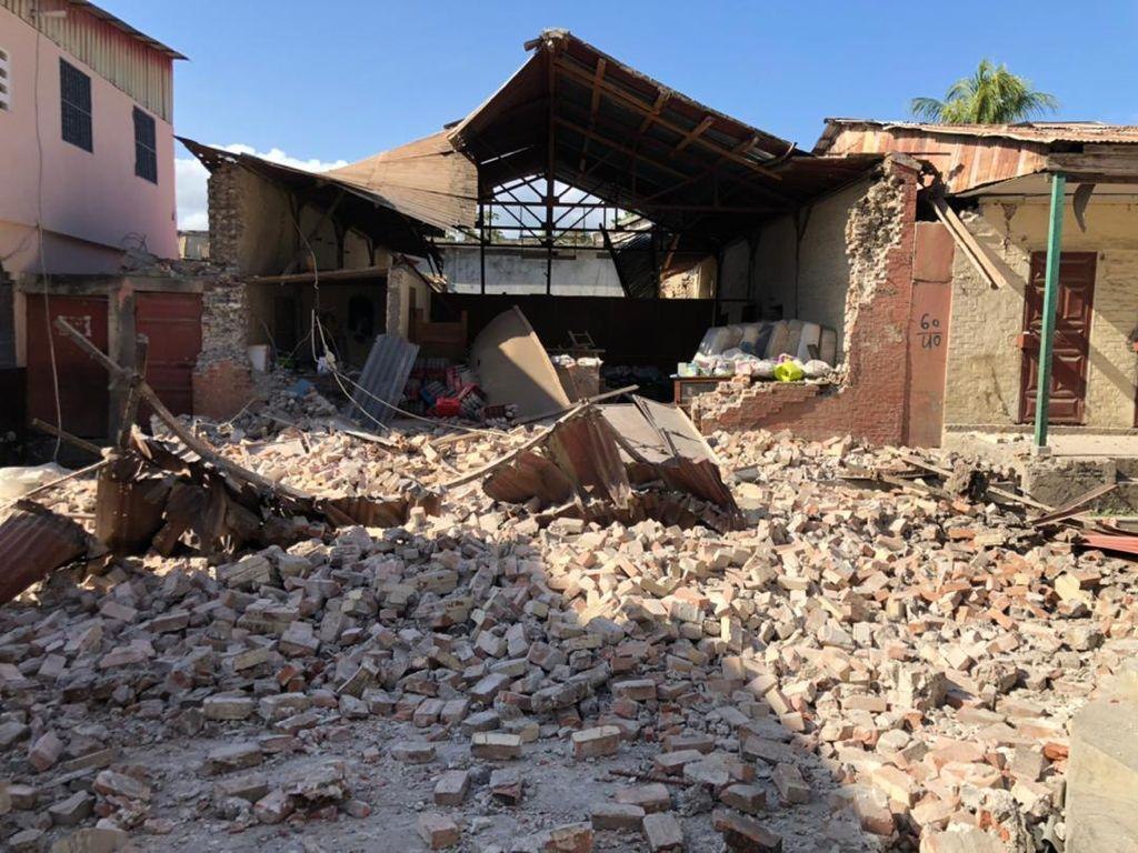
Haiti’s national seismometer network was down during the 2021 magnitude-7.2 earthquake, but a collection of low-cost citizen-hosted seismometers filled in.
By Eric Calais, Ph.D., Ecole normale supérieure, and co-authors
Citation: Calais, E., 2022, Haiti earthquake captured by citizen-seismologists, Temblor, http://doi.org/10.32858/temblor.245
This article is also available in French.
On August 14, 2021, Haiti was struck by a magnitude-7.2 earthquake, eleven years after the devastating 2010 magnitude-7.0 event. Because the 2021 temblor affected a mostly rural and sparsely populated area, it had a much smaller impact than its 2010 predecessor, which killed more than 200,000 people and destroyed parts of the capital, Port-au-Prince.
But in 2021, hard-to-reach rural communities took an unexpected toll. At least 5,000 landslides made crop fields inaccessible during seed season, and a tropical storm swept over the island just two days after the earthquake. Travel to the field for aid relief or scientific investigations was hazardous because the road leading to the affected area is controlled by violent armed gangs. On top of all that, the national seismic network was inoperative during the event — a chronic situation in Haiti even prior to the 2021 earthquake.
Seismologists could have lacked even the most basic information about the event for months, if it was not for Haitian citizen-seismologists.
Better some data than none
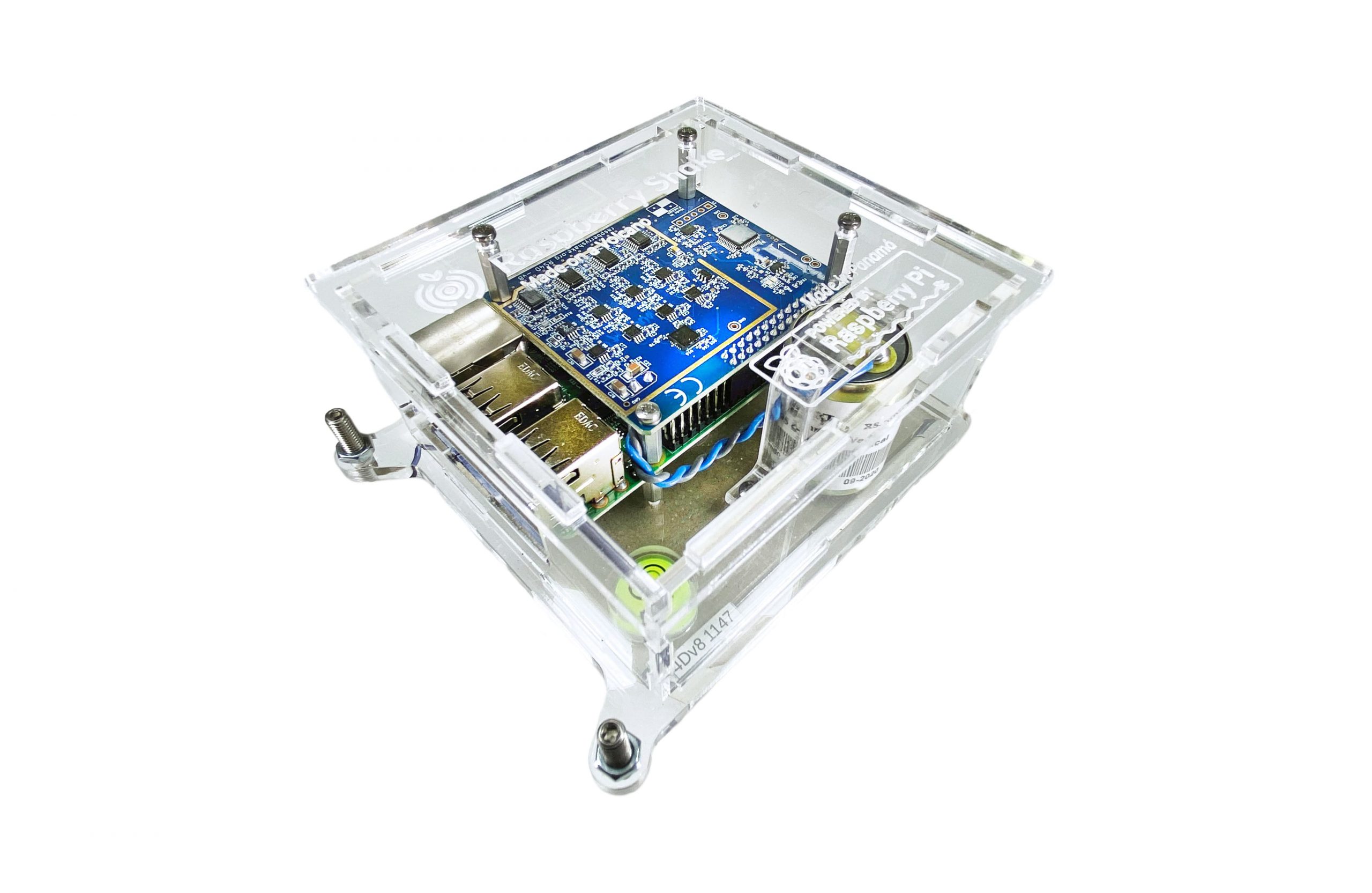
Nearly three years prior to the 2021 earthquake, in September 2018, colleagues and I learned of Raspberry Shakes which combine a Raspberry Pi computer with a ground motion sensor to become a small, cheap seismometer. Compared to the tens of thousands of dollars for a conventional seismic station, these tissue-box-sized devices cost only a few hundred U.S. dollars. A Raspberry Shake requires no maintenance and only needs a power outlet and internet connection. One can simply lay it on the ground, connect it and forget about it. Its tiny size and minimal burden makes it perfect for installation in individuals’ homes or in schools.
We immediately thought that these simple devices could solve some of the issues with Haiti’s seismic network that were evident after the 2010 earthquake. Raspberry Shakes would have a better chance of long-term survival than complex conventional seismic stations in a country awash in economic and know-how challenges. Admittedly, Raspberry Shakes are less capable than conventional seismometers, as they record seismic signals over a smaller range of frequencies, but when it comes to monitoring local seismicity, they do the job well. Despite the limitations of a Raspberry Shake, it’s better have some data than none!
This also opened the opportunity to involve citizens in the seismic monitoring of their country and to establish a channel of exchange between them and scientists for a reciprocal understanding of the seismic phenomenon and its perception. We contacted colleagues at the Géoazur laboratory, bought five instruments with grant money, and off we went to instrument the country!
Getting seismometers into citizen’s hands
We installed those first instruments at ideally located private residences we had identified through personal contacts in Haiti. At the same time, engineers at Géoazur developed a real-time earthquake information system available publicly on the web, called Ayiti-SÉISMES.
We provided the volunteer hosts with basic information on the device, how to visualize its data and how to access the Ayiti-SÉISMES platform. We made it clear that they were not on the hook if the instrument went down and that it was ok if they lost internet or power temporarily — a frequent situation in Haiti.

Ultimately, most of the volunteers were not that interested in wiggles on a graph — the standard way to view seismic data — but were quite proud to be participating in a broad-scale endeavor that improves their country’s earthquake knowledge, as a sociological investigation showed. Our project now includes sociologists and anthropologists from Haiti and France, who have the key role to engage with Raspberry Shake hosts and their communities and better understand their informational needs.
By August 2021, the Raspberry Shake network in Haiti had grown to 15 stations, while the conventional seismic network was still largely inoperative. Then, a magnitude-7.2 earthquake struck on August 14, 2021.

A strong quake rocks Haiti
The mainshock was large enough to be detected and characterized within minutes by regional and global seismic stations operated by international agencies. They all estimated the magnitude of the earthquake as 7.2 — 40% more energetic than the 2010 event. It was also recorded by five seismometers in Haiti, three of which were Raspberry Shakes. The other two were conventional stations in Port-au-Prince, about 120 kilometers (75 miles) from the epicenter — one U.S. Geological Survey (USGS) accelerometer in the American embassy and one educational broadband instrument in a high school.
Interestingly, two Raspberry Shake devices in the epicentral area that were offline when the earthquake struck were spontaneously brought back to life by their hosts; one simply ran to his internet provider to renew his subscription after feeling the shaking!
Thanks to efforts by Steeve Symithe and Sadrac St. Fleur from the URGéo laboratory of The State University of Haiti, three additional Raspberry Shake instruments were quickly deployed in the area around the epicenter, along with 12 temporary conventional seismometers. Data from Raspberry Shakes are available in real time, and that made all the difference. Temporary conventional stations are not on a real time data link, so we must visit them every couple of months to download the data. Having the Raspberry Shakes connected to the internet gave us a clear picture of what had happened within only two weeks of the mainshock.

As a matter of fact, the smaller earthquakes that follow a major event — called aftershocks — contain a wealth of information about the main shock. In a way, they are the “smoking gun” of the main event because they strike along sections of the fault that slipped during the mainshock. Knowing their 3D distribution allows seismologists to determine the geometry of the fault that slipped, or ruptured, which is essential to understanding the distribution of ground shaking and inform on future hazards. But doing so requires accurately recording the location, including depth, of a lot of aftershocks. This can only be achieved with seismometers located within a few tens of kilometers of the epicenter. The citizen-hosted Raspberry Shake seismometers played an enormous role, as they were the only instruments available close to the epicenter that provided data in real time.
Aftershocks illuminated not one, but two events
Within three weeks following the main event, citizen-hosted Raspberry Shake seismometers detected 1,031 aftershocks between magnitude 1.4 and 5.8. For comparison, only 37 aftershocks were detected by the global USGS network for the same time interval. We quickly observed that aftershocks were mostly located to the north of the Enriquillo Fault, which is the main boundary between the North American and Caribbean tectonic plates.
These smaller earthquakes fell in two separate clusters. One group struck in the east between four and 20 kilometers (2-12 miles) depth along an east-west plane tilted to the north. The mainshock struck at the base of this cluster. A second group of aftershocks struck to the west, mostly at depths shallower than 10 kilometers (six miles). These earthquakes struck along a near-vertical plane. In total, the aftershocks extended as much as 80 kilometers (50 miles), but it looked as though the earthquake was actually two events merged into one!

To confirm this finding, we first used conventional regional seismic stations to calculate the orientation and direction of the fault slip that occurred during the event. We indeed found that the event involved two areas of larger slip that corresponded to the two aftershock clusters described above. The first area, to the east, showed largely reverse motion — where the upper side of the fault moved upward relative to the bottom — between 0 and 12 km depth. The second area, to the west, was limited to the upper four kilometers of the crust and saw left-lateral strike slip motion.
We further confirmed these two events using satellite data from the Sentinel 1 A and B and ALOS-2 satellites that measures ground motion. These data show significant vertical motion near the epicenter, consistent with the reverse motion observed in the aftershocks, and horizontal motion further west, consistent with shallow strike slip motion on a fault parallel to the Enriquillo Fault. The match between the aftershock distribution determined thanks to the citizen-hosted Raspberry Shake seismometers and these independent results was astonishing.
Raspberry Shakes inform future earthquake safety
The Raspberry Shake closest to the epicenter that was operational during the main shaking was located in Saint Louis du Sud, 20 kilometers (12 miles) from the epicenter, in a beautiful Caribbean bay, hosted by a company that is building a local cargo port. It recorded, in real-time, a ground acceleration that exceeded the Haiti building code for one to two-story buildings. The seismometer therefore showed that many buildings likely did not perform well during the mainshock, even before getting information from field crews.
Immediately following an earthquake, individuals and emergency managers want to know when aftershocks will quiet down enough that first responders can safely enter buildings. We wanted to know if a single station could be used to determine this in real time. We used machine learning to build an aftershock catalog using that single Raspberry Shake station, to forecast the aftershock decay rates. We found that that single station provided the same forecast as the one we derived from the full network of Raspberry Shake instruments. This highlights the potential of low-cost instrumentation for earthquake response in seismically active regions with limited resources.
Altogether, data from the citizen-hosted Raspberry Shake seismometers and from independent sources show that the 2021 Haiti earthquake bears similarities with its 2010 predecessor. They both initiated with reverse faulting — a surprise given the strike-slip nature of the plate boundary — before propagating westward with mostly strike-slip motion. Haiti’s seismic hazard map does not account for the crustal shortening that occurs with reverse faulting. A reappraisal is therefore to include that new information into an updated building code.
This case study demonstrates the added value of citizen seismology for rapid response to earthquakes. Its high cost-benefit ratio makes citizen seismology particularly relevant for regions of similar socio-economic level to Haiti, where the implementation of conventional networks operated by official institutions can be difficult.
The following researchers are co-authors on the study, which was published this month in Science.
S. Symithe, Université d’État d’Haïti, URGéo laboratory
T. Monfret, Institut de Recherche pour le Développement, Université Côte d’Azur, Institut de Ciències del Mar
B. Delouis, F. Courboulex, J.P. Ampuero, Q. Bletery, J. Chèze, F. Peix, A. Deschamps, B. de Lépinay, Université Côte d’Azur, Centre National de la Recherche Scientifique
A. Lomax, ALomax Scientific
P.E. Lara, Instituto Geofísico del Perú
B. Raimbault, École Normale Supérieure
R. Jolivet, École Normale Supérieure, Institut Universitaire de France
S. Paul, Université Côte d’Azur, Université d’État d’Haïti, URGéo laboratory
S. St Fleur, D. Boisson, URGéo laboratory, Université d’État d’Haïti
Y. Fukushima, Tohoku University
Z. Duputel, Institut de Physique du Globe, Université de Paris
L. Xu, L. Meng, University of California, Los Angeles
- Venezuela’s doublet leaned toward Caracas - June 30, 2026
- Is Southern California’s Cajon Pass an ‘earthquake gate’ ready to open? - June 29, 2026
- Philippines magnitude 7.8 shock may have loaded the central Cotabato subduction zone - June 11, 2026