By Alka Tripathy-Lang, Ph.D. (@DrAlkaTrip)
Taal Volcano, known for its picturesque crater lake, erupted suddenly on Sunday, Jan. 12, 2020, forcing evacuations of nearby villages.
Citation: Alka Tripathy-Lang (2020), Philippine volcano Taal erupts with a fury of earthquakes and ash, Temblor, http://doi.org/10.32858/temblor.066

Since the afternoon of Sunday, Jan. 12, 2020, Taal Volcano in the Philippines has been erupting, with the Philippine government issuing an alert level of 4 (out of 5), indicating a hazardous explosive eruption is possible within hours to days. Circling the planet via social media are spectacular images of several-kilometer high ash clouds intermittently illuminated with mesmerizing volcanic lightning, lava fountains taller than the Empire State Building spouting into the night sky, and most recently, fissures that cut through the ground, homes and roads.

The Philippine government has issued a mandatory evacuation warning to populace residing within a 14-kilometer-radius around Taal; the UN Office for the Coordination of Humanitarian Affairs estimates 450,000 people live in this region. As of this writing, more than 53,000 people are sheltering in evacuation centers, according to the most recent Philippine National Disaster Risk Reduction and Management Council (NDRRMC) report.
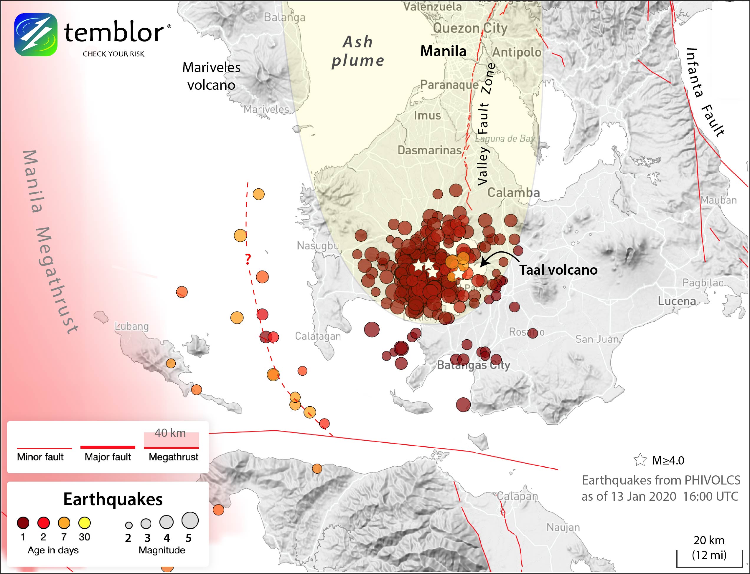
The earth has been rumbling, with the Philippine Institute of Volcanology and Seismology (PHIVOLCS) keeping tabs on the tremors. More than 550 volcanic earthquakes—172 of which were felt by locals according to PHIVOLCS—have shaken the area around Taal between the beginning of the eruption at 1:00 p.m. on Sunday afternoon and Thursday, Jan. 16 at 8 a.m. Key to understanding what’s happening are the timeline of the eruption, the sometimes-violent history of Taal, and how PHIVOLCS monitors Taal and the surrounding region to keep people safe.
Click on the questions below to jump to the section that most interests you, or read on below.
When did Taal begin to stir?
How does PHIVOLCS monitor Taal?
Eruption timeline
Since 2016, the ground elevation on Taal had been decreasing, or deflating. However, starting in January 2019, PHIVOLCS noted that the ground began to rise, and was still measurably higher in March 2019. Since February 2019, gas emissions have also been gradually increasing, indicating more volcanic carbon dioxide dissolved in the waters circulating within the hydrothermal system of the volcano. On March 28, PHIVOLCS raised the alert level of Taal to Alert Level 1, noting that the Taal seismic network, which monitors the region for any hint of ground shaking, began to record more seismic activity than normal, with occasional tremors causing scarcely perceptible to weak shaking, accompanied by smaller quakes that could not be felt. This increased seismicity continued throughout 2019, with PHIVOLCS reporting a total of 4,857 volcanic earthquakes recorded between March 28 and Dec. 1.
On Sunday, Jan. 12, almost a year after activity began to ramp up, the unrest escalated, with PHIVOLCS raising their alert level from 1 to 4 in a matter of hours. At 11 a.m. local time, PHIVOLCS reported that a seismic swarm had commenced. By 1 p.m., steam activity increased inside the main crater, including an explosion of steam and rock that generated a 100-meter-high plume. Alert Level 2, defined as increasing unrest, was declared at 2:30 p.m. At 4:00 p.m., PHIVOLCS declared Alert Level 3 (magmatic unrest), noting that the eruption plume was 1 kilometer high. At 5:30 p.m., PHIVOLCS noted a “tall 10- to 15-kilometer steam-laden tephra column with frequent volcanic lightning that rain[ed] wet ash,” and at 7:30 p.m., Alert Level 4 was declared. In the early morning hours of Jan. 13, lava fountaining was reported.

As of 4 p.m. local time on Jan. 13, PHIVOLCS reported 2-kilometer-high “steam-laden plumes,” with new vents producing more lava fountains. On Jan. 14, PHIVOLCS reported that lava fountains and steam-laden plumes were still active, but fissures, or cracks in the earth, appeared both to the north and southeast of Lake Taal. By 8 a.m. on Jan. 15, PHIVOLCS described the activity as “continuous but generally weaker,” with 1-kilometer-high steam-laden plumes and additional fissures. PHIVOLCS also noted that the numerous volcanic earthquakes recorded—466 between Sunday at 1 p.m. and Wednesday at 8 a.m.— “probably signifies continuous magmatic intrusion beneath the Taal edifice, which may lead to further eruptive activity.”
By 5 p.m. on Wednesday, PHIVOLCS reported that portions of Pansipit River, which connects Lake Taal to the ocean, have dried up, and satellite images indicate that the Main Crater Lake on Volcano Island “has been drained and new vent craters have been formed inside the Main Crater and on the north flank of the volcano.” As of 10 a.m. Thursday morning, Alert Level 4 is still in effect.
*By 8 a.m., Friday Jan. 17, PHIVOLCS noted existing fissures widened by several centimeters, and “a steaming fissure [had] been newly observed on the northern slopes of Taal Volcano Island.” Receding shorelines were observed around the entirety of Taal Lake. The Taal Volcano network, which is different from the Philippine Seismic network, recorded 944 volcanic earthquakes, including 29 low-frequency earthquakes. PHIVOLCS considers such activity to indicates magma is intruding below the volcanic edifice. As of 5 p.m. Friday afternoon, PHIVOLCS continued to keep Alert Level 4 in effect.
*eruption timeline updated Saturday, Jan. 18 at 2:30 a.m., local time, to reflect the most recent volcano bulletins released by PHIVOLCS
Why is Taal so dangerous?
Taal is one of the most dangerous volcanoes in the Philippines in part because more than 450,000 people live within a 14-kilometer radius. To make matters worse, Taal has the potential to seriously impact the metropolitan Manila area, which is home to more than 12 million people. Only 60 kilometers away, Manila was blanketed with fragments of rock and ash in 1754 by a powerful eruption [Torres et al., 1995].
However, Taal is also menacing because of its ability to produce highly explosive eruptions [Newhall et al., 2018]. Taal has a nested island structure: A tiny volcanic island sits within Crater Lake, which sits on Volcano Island, which resides in Lake Taal, on the Philippine island of Luzon. That structure—molten rock underneath water—“gives lots of opportunities for magma-water interaction, which means high explosivity,” says Beth Bartel, a scientist who has worked on Taal and is now at UNAVCO in Colorado.

High explosivity means that certain volcanic hazards, like ballistic projectiles and base surges, are more problematic than others. At Taal, Bartel says, “lava flows are just one of [the hazards].” She continues, “otherwise, it’s all about rocks and water interacting to cause explosions and combining to travel across the lake.”
Communities along the shores of Lake Taal are particularly at risk from ballistic projectiles: centimeter- to meter-sized rock fragments that are produced or ejected during explosive volcanic eruptions and that move through the atmosphere like artillery shells, according to Taddeucci et al., [2017]. PHIVOLCS created a ballistic projectile hazard map, showing that much of the susceptible area is within the lake, plus small portions of the western shore. This means that anyone fleeing Volcano Island by boat, in addition to those along the shore, could be exposed to these hazards.

Another hazard for lakeside communities, also mapped by PHIVOLCS, is called a base surge, for which Taal is famous, Bartel says. When a volcano explodes, instead of material going up, sometimes “it goes out in all directions, sandblasting everything in its path.” Even though Taal is in a lake, she warns that base surges “can travel across the lake and affect people living on the shore.” Bartel says Taal “is the first place where [base surges] were observed and described.”


Volcanic ash is a large problem for communities both close to Taal and farther away. “It affects homes, livestock and air quality, so it’s a real threat to the entire region,” Bartel says. Wind direction can sway which populations are affected by ash. In this eruption, wind initially blew ash northwest toward Manila, grounding flights and shutting the airport down (the airport has since reopened). On Monday, PHIVOLCS warned communities southwest of Taal to be on alert for ash-related hazards, with attention to breathing problems and roof collapse.

PHIVOLCS is also concerned about the potential for volcanic tsunamis, a hazard for which PHIVOLCS specifically warned the local population on Sunday. In the case of Taal, Bartel describes this as “sloshing,” with big waves “going back and forth.” She points out that this can exacerbate attempts to evacuate people on Volcano Island by boat, since these waves in a nearly closed basin can capsize the boats, in addition to wreaking havoc on the shoreline. In Taal’s 1965 eruption, fleeing residents in capsized boats accounted for many of the 190 fatalities, with waves reaching 4.7 meters above lake level, and water surging inland by as much as 80 meters [Moore et al., 1966].

Keeping an eye and an ear on Taal
PHIVOLCS has acknowledged the danger posed by Taal, selecting it as a “Decade Volcano” in 1996. Decade Volcanoes were those identified by the International Association of Volcanology and Chemistry of the Earth’s Interior (IAVCEI) with a history of large, destructive eruptions that are near populated areas.
Installed near or around Taal are seismometers, GPS stations, a tiltmeter, tidal gauges, and leveling lines, among other instruments, all of which are monitored by PHIVOLCS. They also collect water samples from both lakes twice monthly for geochemical analysis, according to the World Organization of Volcano Observatories. But what can these instruments tell us?

Seismometers tell scientists when the earth shakes for any number of reasons, including tectonic earthquakes, landslides, and importantly, volcanic earthquakes. According to the U.S. Geological Survey (USGS), a well-distributed volcano seismic network can rapidly and precisely locate volcanic earthquakes, helping scientists “see” a volcano’s plumbing and pinpoint in which pipes the magma and trapped fluids/gases reside. Interestingly, volcanic earthquakes recorded in and around Taal appeared to begin on Volcano Island, but now seem scattered, with a high concentration of tremors on the west side of the lake. This coincides with where many of the fissures have opened. Ross Stein, a seismologist and CEO of Temblor says, “The Taal seismicity is swarm-like in character, with sustained magnitude-4 and smaller quakes, rather than a mainshock followed by a decaying rate of aftershocks. Swarms are common in volcanic events and when faults creep,” Stein says, but, “the Valley Fault Zone connects Taal Volcano with metro Manila, so this is the fault to watch for any creep or quakes.”
GPS, coupled with tiltmeters, tells scientists about how the ground around volcanoes can swell, sink or crack because of magma, gas or fluid moving around. Specifically, Bartel says, “they tell us about pressurization in the volcano. Volcanoes inflate and deflate like a balloon, so we’re looking for rapid changes, which can tell PHIVOLCS something is out of the ordinary.” It’s with these instruments that PHIVOLCS noted slight inflation of the ground in January 2019 that, when coupled with additional information from seismometers, led to the initial Alert Level 1 in March 2019.
Video showing how scientists monitor deformation on a volcano using GPS. Credit: Incorporated Research Institutions for Seismology (IRIS)
Video showing how scientists monitor deformation on a volcano using a tiltmeter. Credit: Incorporated Research Institutions for Seismology (IRIS)
PHIVOLCS also maintains at least one infrasonic sensor, a microphone that measures the sound released by volcanic eruptions that are too low frequency for the human ear to hear (below 20 Hz). Because infrasound is unaffected by cloud cover, it can help scientists listen to a volcano while it erupts.
All of these tools, plus a few others PHIVOLCS has at their disposal, including the tool of visual observation, helped them rapidly assess the situation on Sunday and raise the alert level appropriately and quickly.
PHIVOLCS was not available to comment on this story. However, for official and up-to-date information on this eruption, follow PHIVOLCS on twitter (@PHIVOLCS-DOST) or visit their website.
References
Moore, J.G., Nakamura, K., and Alcaraz, A., 1966. The 1965 Eruption of Taal Volcano. Science, v. 151, 955-960.
Newhall, C., Self, S., and Robock, A., 2018. Anticipating future Volcanic Explosivity Index (VEI) 7 eruptions and their chilling impacts. Geosphere, v. 14, 572-603. doi.org/10.1130/GES01513.1
Taddeucci, J., Alatorre-Ibargüengoitia, M.A., Cruz-Vázquez, O., Del Bollo, E., Scarlato, P., and Ricci, T., 2017. In-flight dynamics of volcanic ballistic projectiles. Reviews of Geophysics, v. 55, 675-718. doi.org/10.1002/2017RG000564
Torres, R.C., Self, S., and Punongbayan, R.S., 1995. Attention Focusses on Taal: Decade Volcano of the Philippines. Eos, v. 76, 241-248. doi.org/10.1029/95EO00137
- Living through the Loma Prieta earthquake - October 21, 2021
- The Great Quake Debate: an interview with seismologist and author Susan Hough - August 27, 2020
- Salton Sea Swarm quiets down - August 12, 2020