If you would like to protect yourself from earthquakes by having a quake prep consult, call QuakePrepare at 707-965-3299
By David Jacobson, Temblor

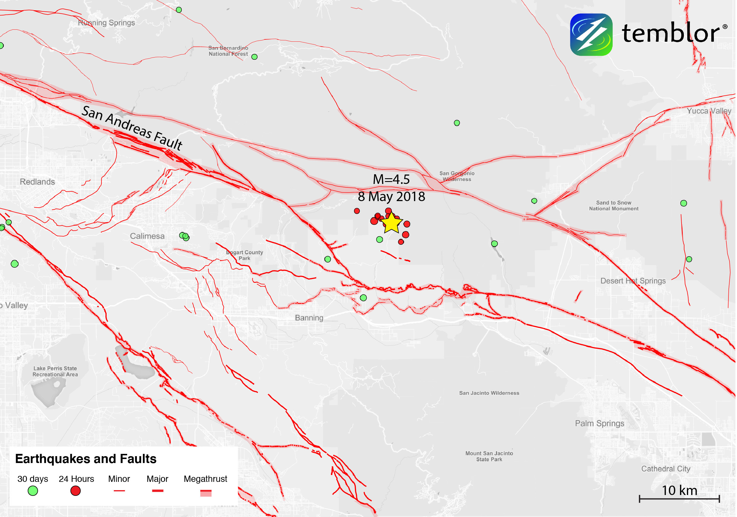
Southern California woken by M=4.5 earthquake
At 4:49 a.m. local time a M=4.5 earthquake struck near the San Andreas Fault, approximately 100 km east of Los Angeles. This quake struck within the San Bernardino Mountains at a depth of 12.9 km. According to the USGS ShakeMap, strong shaking was recorded near the epicenter, and by 10:30 a.m. this morning, over 10,000 people had filled out felt reports on the USGS website. Fortunately, no damage or injuries have been reported, and they are unlikely due to the moderate magnitude of the quake.
The San Andreas Fault Zone
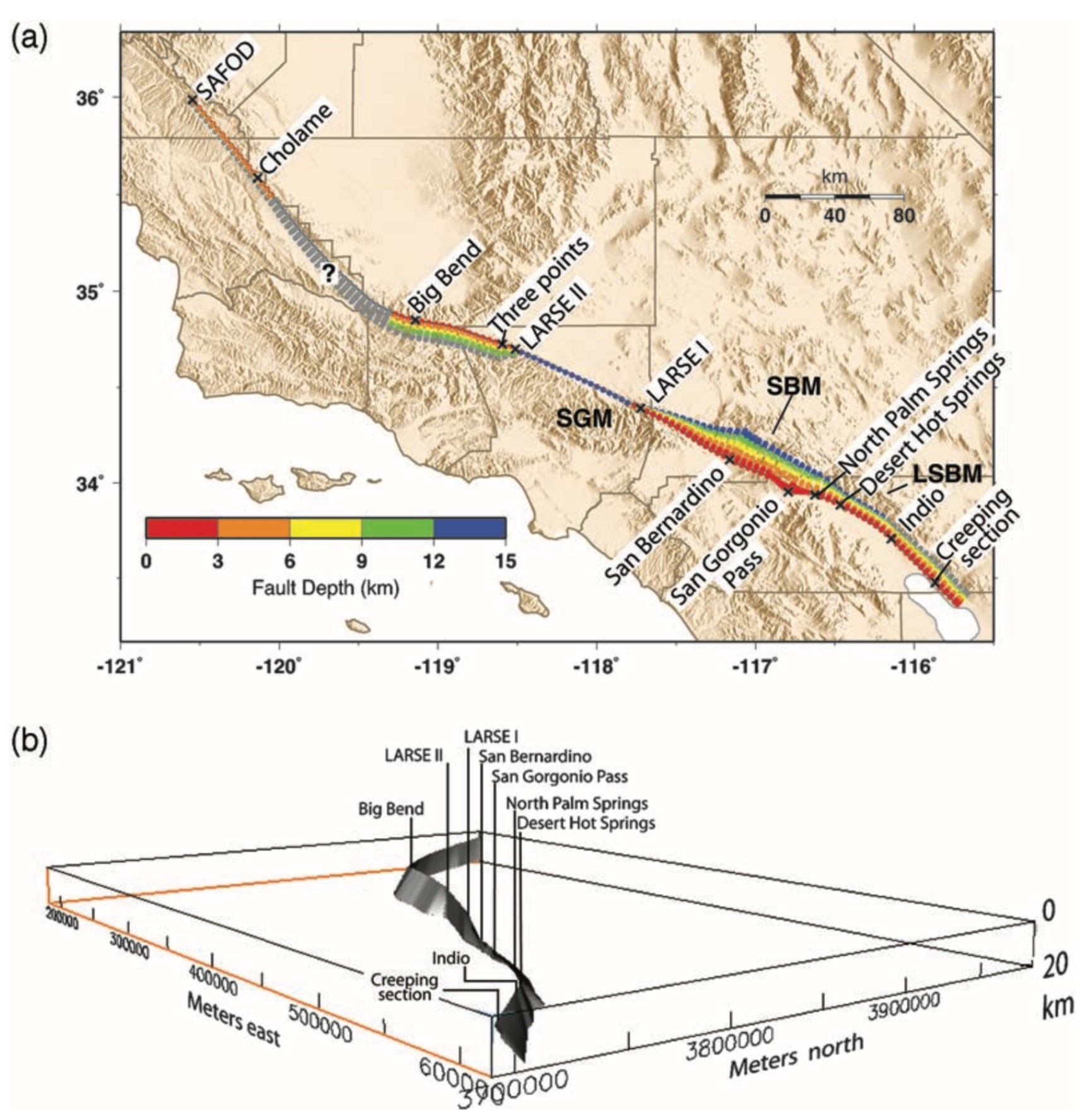
Today’s earthquake struck in the San Andreas Fault Zone, within the San Bernardino Mountains section. The focal mechanism produced by the USGS shows that the quake was both right-lateral strike-slip and compressional in nature on a structure oriented almost purely east-west. While most people only think of the San Andreas Fault as a strike-slip structure, within this area, the story is much different. As the San Andreas weaves its way through Southern California, it has many bends separated by straight sections. While in the straight portions, like through the Mojave Desert, fault dips often exceed 80°, in the bends, subsurface magnetic data shows that in areas such as San Bernardino and Indio, the fault dips between 37°-65° to the northeast. This is a striking difference compared to the dip of the San Andreas within the western Traverse Range, where it dips approximately 55° to the southwest.
Due to these variable dips, at depth, the Southern San Andreas Fault has a shape described as a crude propeller (see figure below). Because of this variation, the fact that near North Palm Springs, the San Andreas Fault dips at 52° (today’s earthquake occurred on a structure dipping 68°), and because the San Andreas has a much different orientation to that of the structure on which today’s earthquake struck, it is unlikely today’s quake was on the main strand of the San Andreas. While the possibility cannot be ruled out, it was likely on one of the many other strands in the region.
The many faults strands in this area has led seismologists to call this region the “San Gorgonio knot.” According to Dr. Lucy Jones, this is because many small faults intersect, and because the San Andreas is not clearly defined. The epicenter of today’s earthquake is also of note as it is just to the west of where a M=5.9 struck in 1986. That quake had a similar focal mechanism and occurred between the Mission Creek and Banning segments of the San Andreas Fault.
What could happen here?
Because of the tectonic setting of today’s earthquake, it should not be considered surprising. Such a magnitude is common in California, and according to Dr. Jones, this is the only portion of the Southern San Andreas that produces smaller quakes. Nonetheless, it is a reminder that we do live in earthquake country, and people should prepare themselves for what could happen. Using the Global Earthquake Activity Rate (GEAR) model, we can see what is expected to occur in our lifetime. This model, which is available in Temblor, uses global strain rates and the last 40 years of seismicity to forecast the likely earthquake magnitude in your lifetime anywhere on earth. In the figure below, the GEAR model shows that in the location of today’s earthquake, a M=6.9 is likely. Such an event would likely cause significant damage in Southern California, and highlights the need for education and preparedness.

References
USGS
CalTech
Gary S. Fuis, Daniel S. Scheirer, Victoria E. Langenheim, and Monica D. Kohler, A New Perspective on the Geometry of the San Andreas Fault in Southern California and Its Relationship to Lithospheric Structure, Bulletin of the Seismological Society of America, Vol. 102, No. 1, pp. 236–251, February 2012, doi: 10.1785/0120110041
Wenzheng Yang, Egill Hauksson, and Peter M. Shearer, Computing a Large Refined Catalog of Focal Mechanisms for Southern California (1981–2010): Temporal Stability of the Style of Faulting, Bulletin of the Seismological Society of America, Vol. 102, No. 3, pp. 1179–1194, June 2012, doi: 10.1785/0120110311
LUCILE M. JONES, L. KATHERINE HUTTON, DOUGLAS D. GIVEN, AND CLARENCE R. ALLEN, THE NORTH PALM SPRINGS, CALIFORNIA, EARTHQUAKE SEQUENCE OF JULY 1986, Bulletin of the Seismological Society of America, Vol. 76, No. 6, pp. 1830-1837, December 1986
Lucy Jones Twitter Feed
- Beware quiet segments of the Philippine Fault - May 16, 2025
-
ډیری عوامل افغاني ټولنې د زلزلې پر وړاندې زیانمنوي
- August 11, 2022 - What’s happening this week in Humboldt County, California: The squeeze - February 6, 2019