By David Jacobson, Temblor and Dr. Lauren Alexander Augustine, National Academy of Sciences

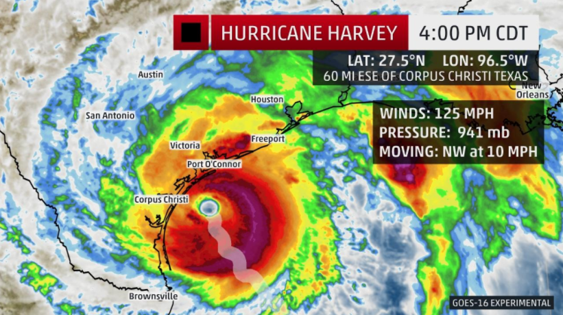
As Hurricane Harvey barrels towards the Texas coastline, slating to become the first Category 3 hurricane to hit the country in almost 12 years, residents of the Gulf Coast are bracing for extreme flooding from both rainfall and storm surge. As of 2 p.m. West Coast time, Harvey has sustained winds of 125 mph, and is scheduled to make landfall tonight, though its effects are already being felt. This morning, we spoke with Dr. Lauren Alexander Augustine, the Director of the Program on Risk, Resilience, and Extreme Events at the National Academy of Sciences to learn about the threat posed by this storm, and how communities are preparing, and becoming more resilient.
In response to this storm, thousands of residents have evacuated, or have been advised to evacuate by local governments. Additionally, FEMA Region 6, which includes the states of Texas, Louisiana, New Mexico, Arkansas, and Oklahoma has been activated. This means that emergency response is already being prepared and people are being put in place, even before a presidential declaration is made. These actions, Dr. Augustine said, are some of the lessons learned from 2005 when a series of hurricanes, including Katrina, Rita, and Wilma swept through the Gulf of Mexico, causing billions of dollars of damage, and claiming many lives. Since those events, risk communication has dramatically improved, leading to greater collaboration between government and non-government organizations, both of which, play a large role during natural disasters. All of this is done in an attempt to lessen the impacts these types of storms have.

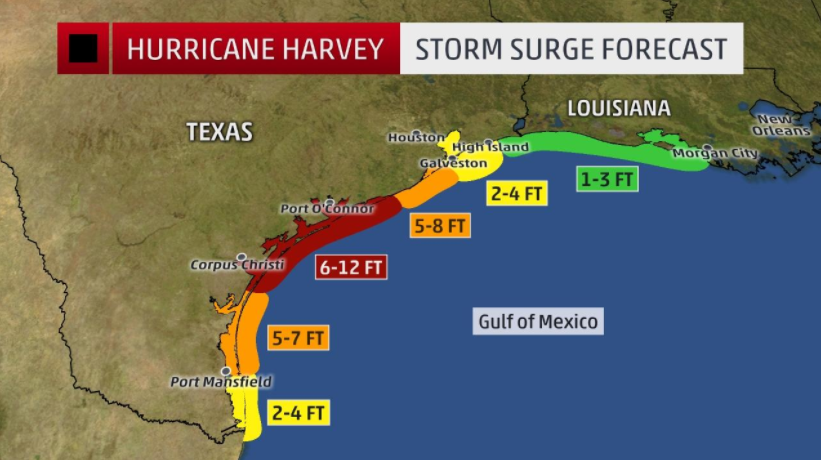
While news organizations tend to highlight the wind speeds hurricanes bring, Dr. Augustine stressed that the greatest risk to human life will be the storm surge, that could reach 12 feet in some places, and the more than two feet of rainfall Texas is projected to receive. Flooding at this level could take weeks to recede. Such high rainfall totals are expected because once the storm makes landfall, it will stall and rain over the region for several more days. This is a problem for a city like Houston, which does not drain well due to its soil, topography, and high table. Nonetheless, because of the tragic events in New Orleans in 2005, significant lessons were learned in governance. For example, there is a slow transition away from the idea that a false alarm is an expensive waste of time, to that a false alarm is a great drill because it allows people to best prepare and make emergency arrangements. In the case of hurricanes and flooding, this can include purchasing flood insurance, which Dr. Augustine says will be a major demarcation in how quickly people recover from this storm.
Even though Hurricane Harvey will likely leave the national spotlight following the worst effects, it is important to remember that recovery from a large storm or other natural disaster can take decades. Additionally, while Texas will receive the brunt of the physical effects, impacts from Hurricane Harvey will be felt around the country. There is likely to be a rise in gas prices, and shipping routes for the Port of Houston will be impacted. Therefore, the focus is not on how do we prevent disasters like this, but how do we live with them? Because storms and flooding are frequent, we can prepare, for the more we do ahead of time, the better things will be on the backend. Dr. Augustine also said that because of all that we have learned in the last 12 years, she is hopeful that Texas and federal agencies are going to come out successful in managing this natural disaster.

References
FEMA
Weather.com
NOAA
NASA
Personal communication with Dr. Lauren Alexander Augustine, National Academy of Sciences
- Beware quiet segments of the Philippine Fault - May 16, 2025
-
ډیری عوامل افغاني ټولنې د زلزلې پر وړاندې زیانمنوي
- August 11, 2022 - What’s happening this week in Humboldt County, California: The squeeze - February 6, 2019