By David Jacobson, Temblor

Last night, at 11:18 p.m. local time, a M=4.8 earthquake struck the city of San Juan Argentina, which is home to over 110,000 people. Fortunately, shaking was not strong enough to cause any reported damage in the capital of this western Argentinian province. Despite the fact that the USGS does not have a focal mechanism, based on the compressional regime of the region, and faults mapped by the South American Risk Assessment (SARA) project, it likely occurred on a thrust fault. The thrust faults in this area have been responsible for two damaging earthquakes since 1944, illustrating the seismic hazard of the region.

This part of Argentina, known as the Sierra Pie de Palo, is characterized by north-south-oriented mountain ranges, separated by large basins. The majority of these mountain ranges are bounded by reverse faults, which dip moderately to the east. In the area around San Juan, the Rinconada, Zonda, Las Tapias-Villicum, and La Laja faults have all been mapped by the SARA project and pose a risk to the city. Professor Carlos Costa at the Universidad Nacional de San Luis in Argentina believes that yesterday’s event “could be linked to the east-dipping Villicum-Las Tapias thrust fault.”
In 1977, a M=7.4 earthquake occurred 95 km northeast of San Juan. While the city itself did not sustain much damage, in total 65 people died, 284 were injured, and 20,000-40,000 were left homeless in the region. The hardest hit towns were Caucete and Bermejo, where many adobe-style buildings collapsed. This quake also caused severe liquefaction, on the order of hundreds of square kilometers. This was likely due to a combination of strong ground shaking, and young basin sediments.

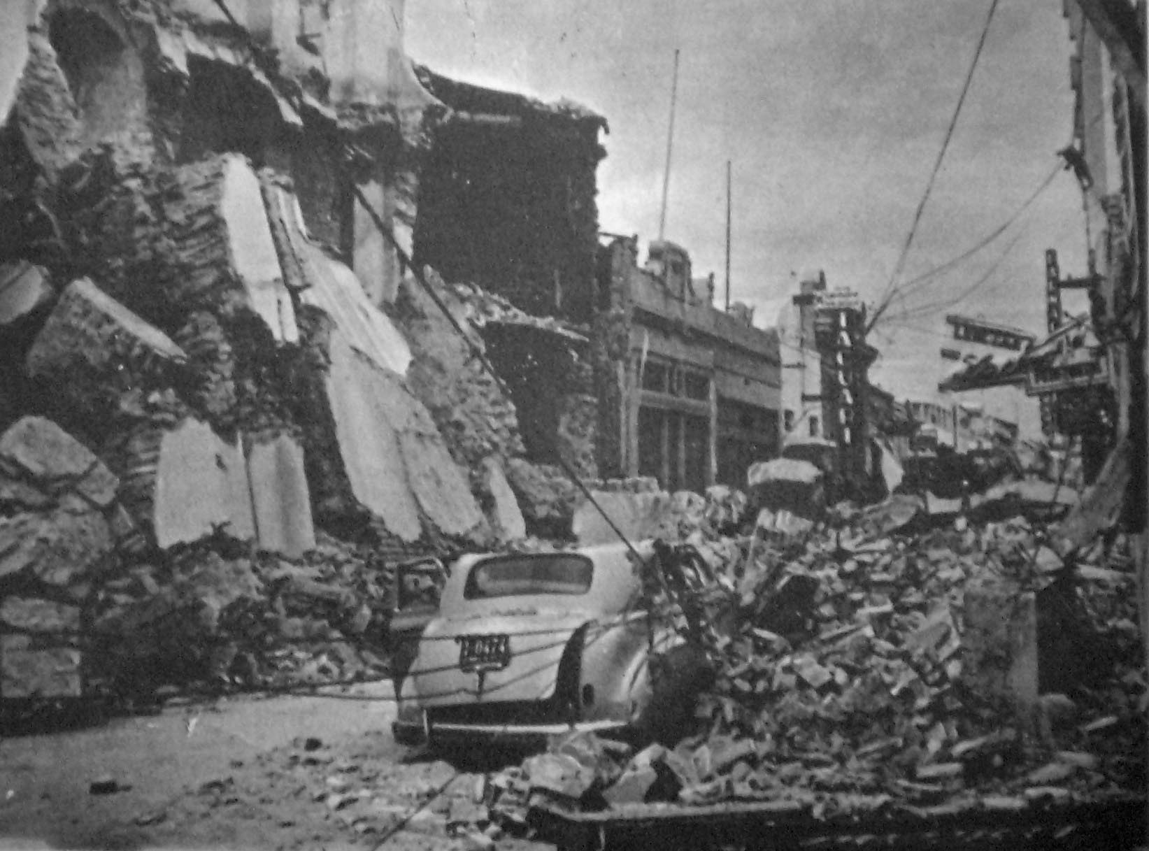
The most damaging earthquake to ever hit San Juan was in January 1944, when a M=7.0 quake destroyed nearly the entire city and left up to 10,000 people dead, 10% of the region’s population. It is estimated that 90% of the buildings in the city were destroyed. However, many people believe this was largely due to the poor build quality of the homes and structures as opposed to just strong ground shaking. At the time of the earthquake, most of the buildings were of adobe construction and not capable of sustaining earthquake shaking. It is important to note that the reconstruction efforts following the earthquake prompted the creation of new building codes, which required that structures be more resilient. This 1944 earthquake is the worst natural disaster to ever hit Argentina.
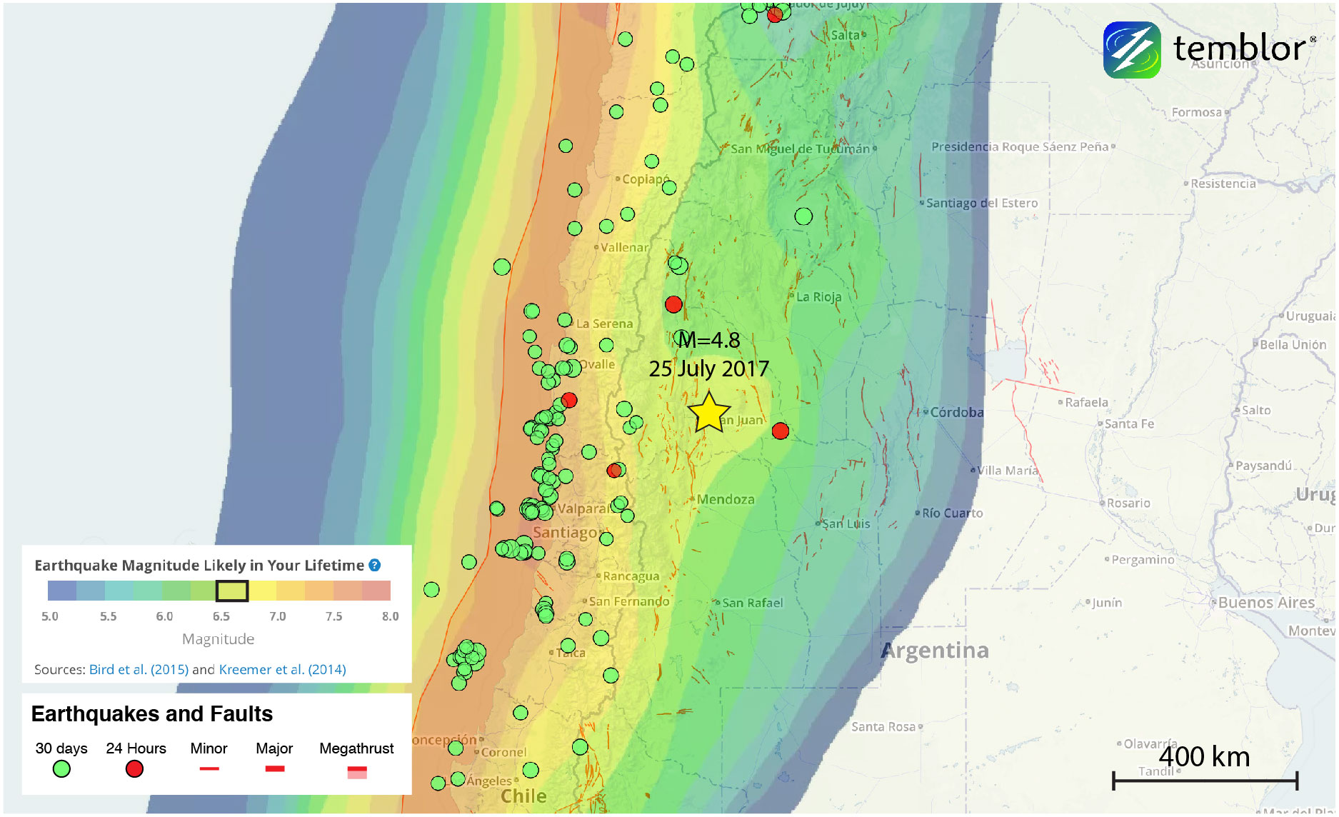
While when most people think of earthquakes in South America they picture Chile, Argentina clearly also has a significant seismic risk. In the figure below, the Global Earthquake Activity Rate (GEAR) model is shown. This model uses global strain rates and seismicity since 1977 to forecast the likely earthquake magnitude in your lifetime anywhere on earth. From the model, one can see that the region around San Juan is susceptible to M=6.5+earthquakes, meaning last night’s M=4.8 quake should not be considered surprising. The reason why the GEAR model has a lobe surrounding San Juan is because the M=7.4 earthquake in 1977 is included in calculations, raising the seismic hazard of the entire region. However, because there was also a large quake in 1944, a high seismic hazard seems reasonable.
References
USGS
European-Mediterranean Seismological Centre
C.J. Langer and Stephen Hartzell, Rupture distribution of the 1977 western Argentina earthquake, Physics of the Earth and Planetary Interiors 94 (1996) 121-132
Katharine Kadinsky-Cade, Robert Reilinger, and Bryan Isacks, Surface Deformation Associated With the November 23, 1977, Caucete, Argentina, Earthquake Sequence, Journal of Geophysical Research, Vol 90, No B14, Pages 12,691-12,700, December 10, 1985
Summary of San Juan, Argentina Earthquake of Novermber 23, 1977 by Rojahn of U.S. Geological Survey
Personal Communication with Professor Carlos Costa (Universidad Nacional de San Luis – Argentina)
- Beware quiet segments of the Philippine Fault - May 16, 2025
-
ډیری عوامل افغاني ټولنې د زلزلې پر وړاندې زیانمنوي
- August 11, 2022 - What’s happening this week in Humboldt County, California: The squeeze - February 6, 2019