
By David Jacobson, M.Sc., Temblor
Click here to protect yourself from natural disasters

How bad would a Cascadia Subduction Zone earthquake be for the Pacific Northwest?
In the last month, several studies were published which not only showcase the dangers posed by this 1,000 km-long (600 mi) plate boundary, but highlight where ruptures may be most likely. The findings show that in the cities of Portland and Seattle, the quake could leave hundreds of thousands of properties damaged and destroyed, and that in places like Seattle, which lies in a sediment-filled basin, shaking could be much more severe.
Three years ago, Kathryn Schultz’ Pulitzer Prize-winning New Yorker essay, The Really Big One, thrust the Cascadia Subduction Zone into the public spotlight. While the convergent plate boundary, which extends from Vancouver Island at its north end to California’s Cape Mendocino at the south, had been known to scientists for decades, the article renewed public interest and scientific focus.
Major population centers exposed to significant risk

The two largest cities in the Pacific Northwest, Seattle and Portland, are home to several million people. In the event of a M=9 earthquake, which is what Cascadia is capable of, the impact would be severe. Part of this is due to proximity to the plate boundary to theses urban centers, but also the geology.
The city of Seattle, the nation’s fastest-growing city, lies in the Puget lowland on the shores of Puget Sound and Lake Washington. While the location creates an ideal trade gateway, it also means the city lies atop a deep basin. This has startling consequences for shaking, according to a recent study by scientists at the University of Washington, the USGS, and University of Southern California. They looked at how buildings ranging from 4-40 stories high would sway (engineers call this “drift”) in simulated earthquakes, comparing the ride in the Seattle basin, and outside it. They found that within the basin, buildings swayed at least three times more than outside of it because of stronger, slower shaking. Thus could result in much greater levels of damage throughout the city, and longer recovery times.
In Portland, 233 km (145 mi) south of Seattle, the situation is not much better. The Oregon Department of Geology and Mineral Industries (DOGAMI) recently published an updated scenario of what a M=9 Cascadia event could do to the city. By assessing the shaking throughout the metropolitan area, they found approximately 38-39% (235,000) of the city’s buildings would suffer some level of damage. This emphasizes, is that in the event of a Cascadia event, the impacts will not only be extremely severe, but extremely widespread.
Where is a great rupture most likely to happen?
While scientists do not know where a rupture will strike, there are clues that point to areas which may be more susceptible. Two of these are ‘locking,’ and seismic ‘tremor.’ As tectonic plates move against one another, stress builds up. Eventually, the stress reaches a critical level, the fault leaps forward and an earthquake takes place. Where plates are “locked,” the amount of stress that can be built up is greatest. Therefore, identifying the most locked portions of the Cascadia Subduction Zone sheds light on areas of greatest risk. The figure below shows that along the plate boundary, locking is greatest in Washington on the one hand, and Southern Oregon and Northern California on the other. Northern Oregon shows quite a bit.
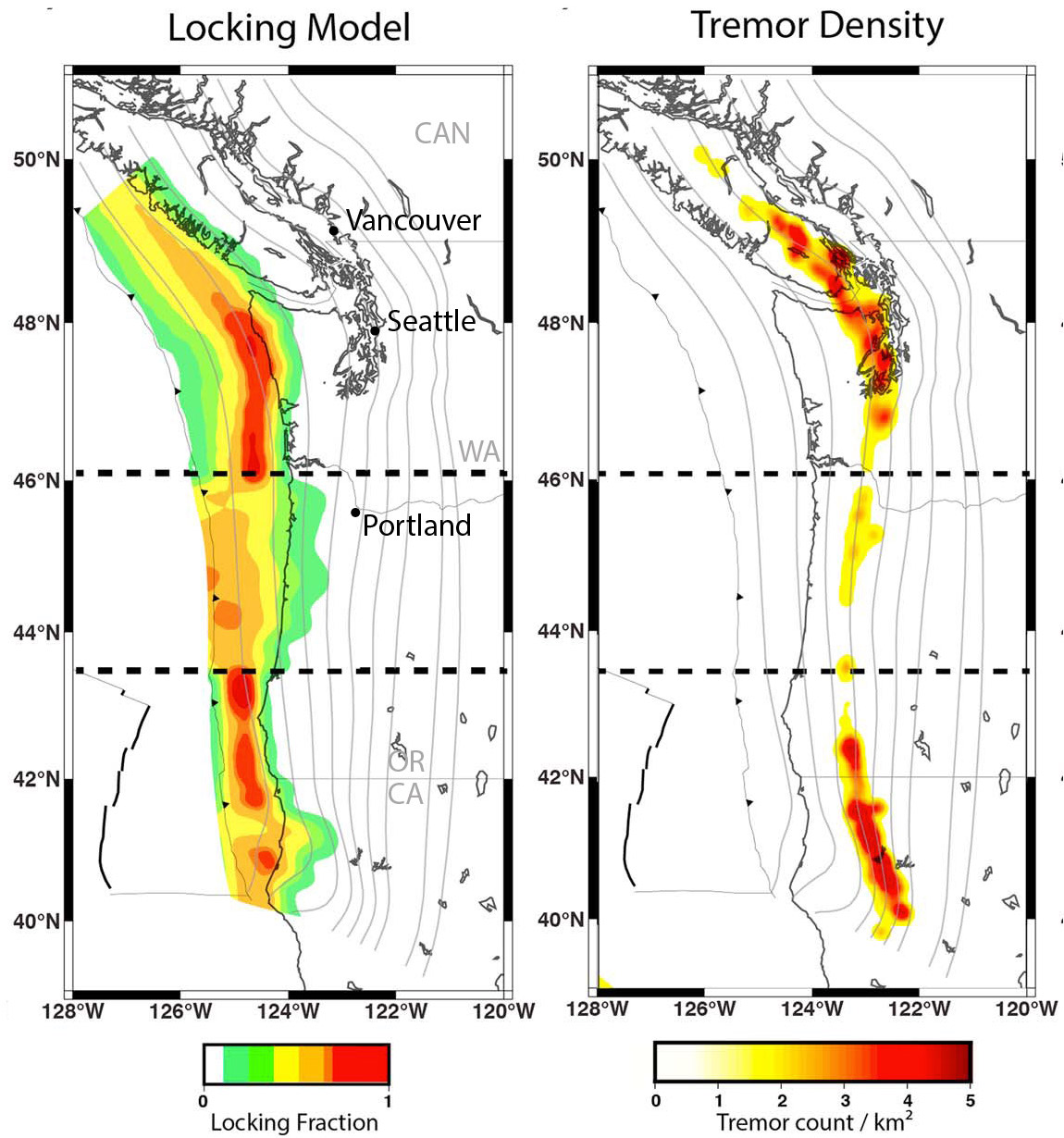
Seismic tremor, which accompanies slow slip events, is common along parts of the Cascadia subduction zones. Tremor seems to be another indication that the fault is locked above a certain depth, but is firing off in very small shocks and slippage just below that depth.
In fact, over the last two weeks, tremor has picked up in Northern Washington, Southern Oregon, and Northern California, as the map from the Pacific Northwest Seismic Network below shows.

Slow slip events are not like regular earthquakes, which last for tens of seconds, but instead last for days to weeks. These events locate just below the locked portions of the fault, and are accompanied high frequency vibration or ‘tremor.’
While scientists are still unsure if periods of intense tremor, such as has occurred for the past two weeks, can presage large earthquakes, strongly-locked tectonic plates tend to produce the largest and most frequent megaquakes. And, a recent study by University of Oregon and University of New Mexico scientists shows that the higher levels of locking and tremor in certain parts of the Pacific Northwest are likely permanent features.
What does this mean for the Pacific Northwest?
Seattle, Portland, and Vancouver B.C. all lie within the zones of elevated tremor and strong locking. In contrast, Eugene lies inland of the portion of the megathrust that is not strongly locked and that produces less tremor. Therefore, the new evidence only confirms and highlights the risk for Vancouver, Seattle, and Portland, and perhaps reduces it for Eugene.
References
John M. Bauer, William J. Burns, and Ian P. Madin, Earthquake Regional Impact Analysis for Clackamas, Multnomah, and Washington Counties, Oregon, Oregon Department of Geology and Mineral Industries Open-File Report O-18-02
N. Marafi, M. Eberhard, J. Berman, E. Wirth, A. Frankel, and J. Vidale. Effects of Simulated Magnitude 9 Earthquake Motions on Structures in the Pacific Northwest. Proceedings of the 11th National Conference in Earthquake Engineering, Earthquake Engineering Research Institute, Los Angeles, CA. 2018.
Bodmer, M., Toomey, D. R., Hooft, E. E. E., & Schmandt, B. (2018). Buoyant asthenosphere beneath Cascadia influences megathrust segmentation. Geophysical Research Letters, 45. https:// doi.org/10.1029/2018GL078700
John E. Vidale and Heidi Houston, Slow slip: A new kind of earthquake, January 2012, Physics Today
- Beware quiet segments of the Philippine Fault - May 16, 2025
-
ډیری عوامل افغاني ټولنې د زلزلې پر وړاندې زیانمنوي
- August 11, 2022 - What’s happening this week in Humboldt County, California: The squeeze - February 6, 2019