By David Jacobson, Temblor

Over the last three days, a small sequence of earthquakes has struck off the coast of Java, Indonesia, resulting in shaking in the capital city of Jakarta. The sequence, which kicked off with a M=6.0, has been followed by four M=4.1+ quakes. Based on the depths of these earthquakes, 36-67 km, they were likely associated with the nearby subduction zone where the Australian plate subducts beneath the Sunda plate at the Java Trench, at a rate of approximately 67 mm/yr. Fortunately, because of the depths of these quakes and their distance from Jakarta (about 160 km), there are no reports of major damage or fatalities. However, closer to the epicenter of the M=6.0, some buildings did collapse.
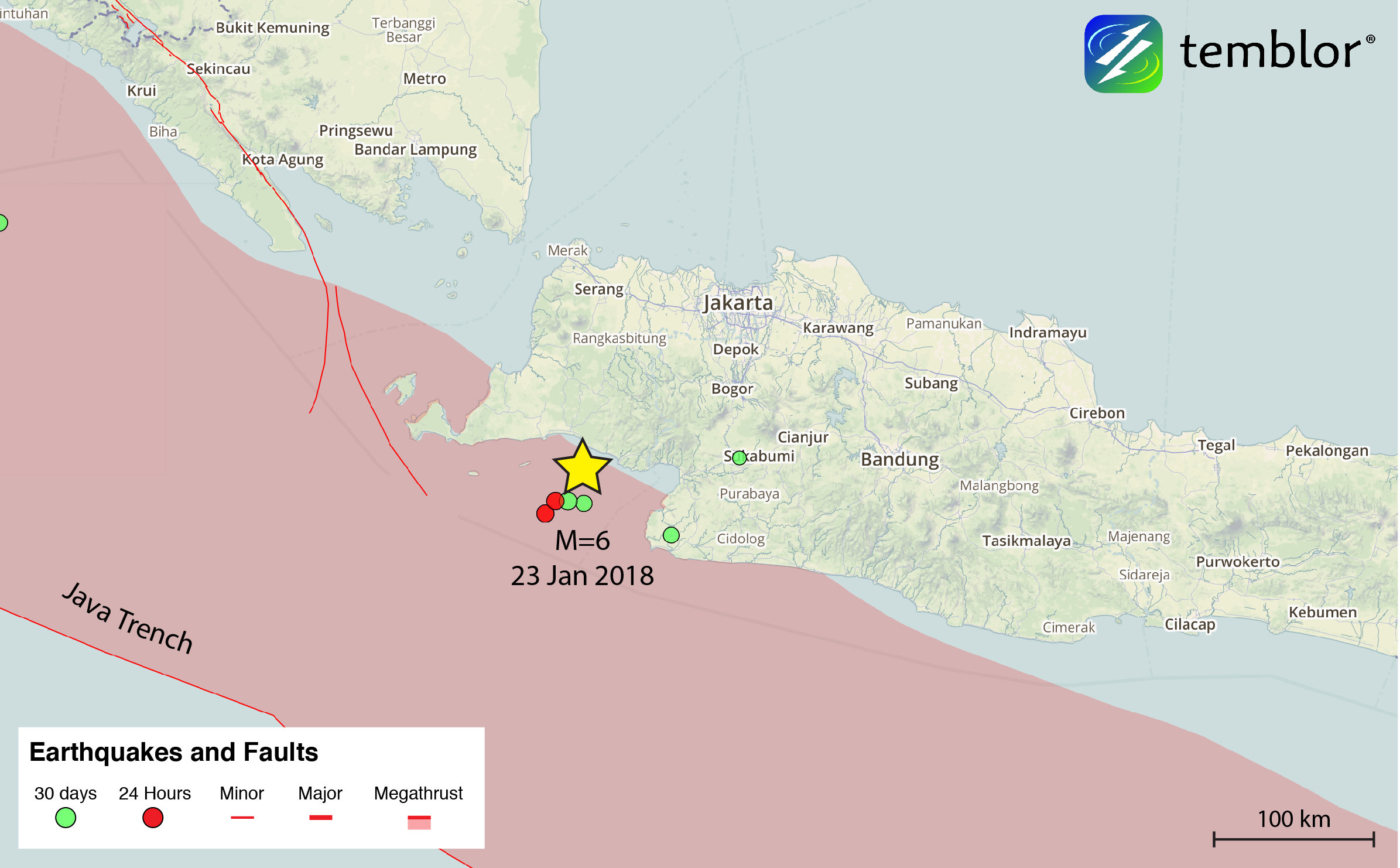
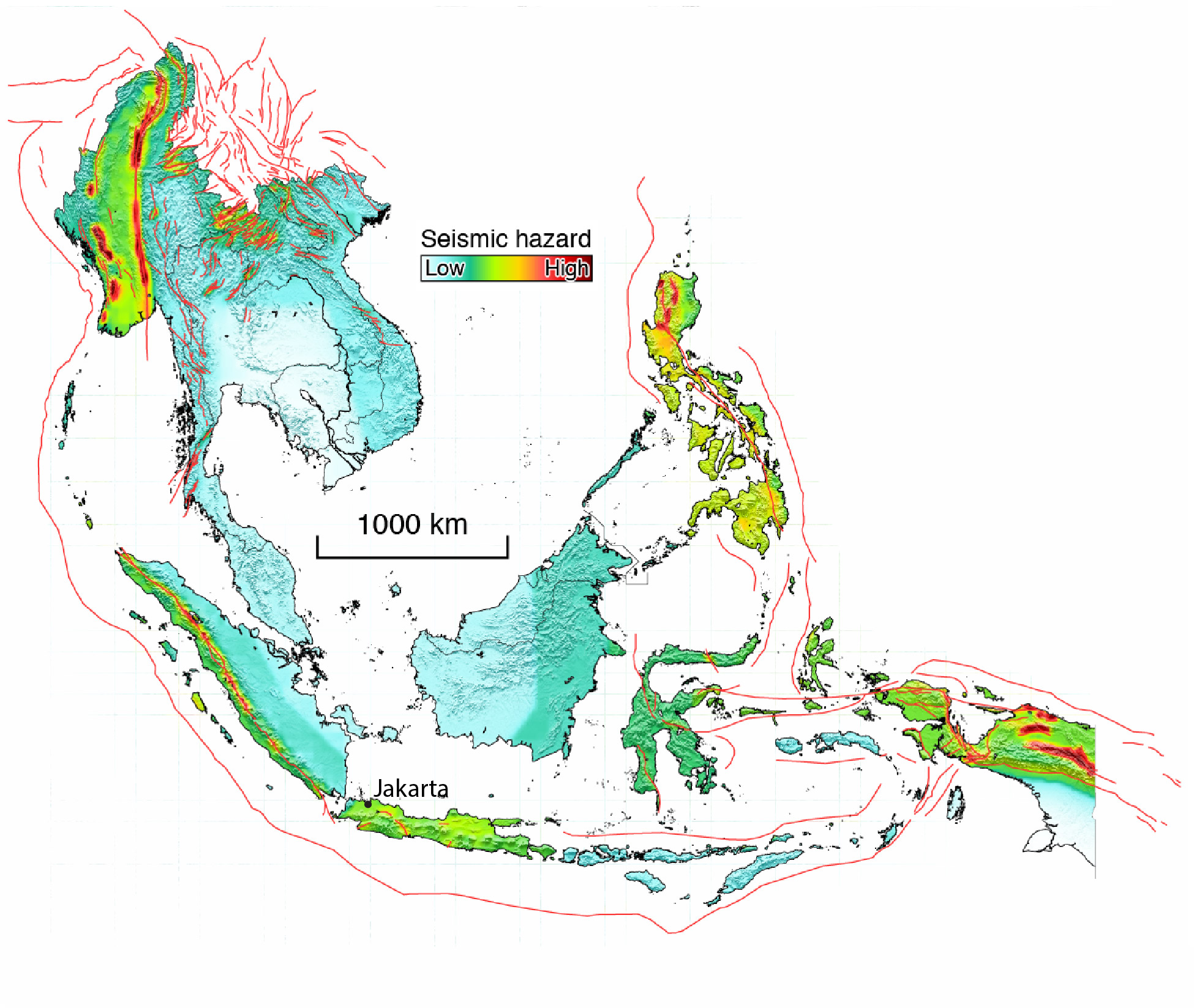
Even though Jakarta was not impacted by this earthquake sequence, there are several earthquake sources which could produce strong shaking in the city of over 30 million people. From past assessments, there are no known sources of seismic activity in Jakarta. However, the offshore subduction zone, as well as four large fault systems within 500 km of the city pose of threat to those that live in the capital. Additionally, Jakarta is built on very thick sedimentary layers, meaning there could be significant amplification (Ridwan et al., 2016), which would likely increase the amount of damage an earthquake would cause. It is because of this that Jakarta is considered to have a moderate seismic hazard. Below we show the just-released seismic hazard map for Indonesia, an effort led by Dr. Chung-Han Chan of EOS Singapore (Chan et al., 2017). This map shows the seismic hazard in all of Southeast Asia and highlights how nearly all of the island of Java, and its 141 million people have a moderate seismic hazard.
In addition to using this seismic hazard map, we can use the Global Earthquake Activity Rate (GEAR) model to see what earthquake people in Jakarta could expect to experience in their lifetime. The GEAR model uses global strain rates and the last 40 years of seismicity to estimate the likely earthquake magnitude in your lifetime anywhere on earth. From the figure below, one can see that around Jakarta, it is M=6.0+. While such a quake could lead to significant damage in the city, there are also areas around Jakarta that could produce much larger events. Therefore, even though the Java section of the Sunda Arc is considered relatively quiet compared to the Sumatra section, where the M=9.1 Boxing Day earthquake in 2004 struck, people on the island of Java should be aware of their seismic risk.

References
USGS
European-Mediterranean Seismological Centre
M. RIDWAN, S. WIDIYANTORO, M. IRSYAM, AFNIMAR & H. YAMANAKA, Development of an engineering bedrock map beneath Jakarta based on microtremor array measurements, From: Cummins, P. R. & Meilano, I. (eds) Geohazards in Indonesia: Earth Science for Disaster Risk Reduction. Geological Society, London, Special Publications, 441, http://doi.org/10.1144/SP441.7
Earth Observatory of Singapore
Chung-Han Chan, et al., Toward uniform probabilistic seismic hazard assessments for Southeast Asia, 2017 AGU Abstract
- Beware quiet segments of the Philippine Fault - May 16, 2025
-
ډیری عوامل افغاني ټولنې د زلزلې پر وړاندې زیانمنوي
- August 11, 2022 - What’s happening this week in Humboldt County, California: The squeeze - February 6, 2019