By David Jacobson and Ross Stein, Ph.D., Temblor
Click here to protect yourself from natural disasters

At 12:29 p.m. local time, a M=5.3 earthquake hit off the coast of California, within the Santa Cruz Basin, approximately 140 km west of the city of Los Angeles. Based on initial USGS data, this quake struck at a depth of 10 km and was almost pure strike-slip in nature. Based on the lack of fault mapping in the region, we cannot say whether movement was right or left-lateral. According to the USGS ShakeMap, moderate shaking was felt on Santa Cruz Island, with weak to light shaking felt on land, including in Los Angeles, Santa Barbara, and Oxnard. Because this quake was centered offshore, no damage is expected, though millions of people were exposed to some degree of shaking.
Off this part of the Southern California coastline, the seafloor is deformed by several large oblique-slip fault systems that help make up the Pacific-North America plate boundary. While there are numerous faults scattered throughout the Borderland region, based on data presented in Legg et. al, 2015, this area was relatively aseismic from 1932-2013, and there are no mapped faults. This lack of seismicity is also seen in the USGS map below of M=2.5+ earthquakes in the last 20 years. What also should be pointed out is how the earthquakes do not tend to follow the faults. However, what we can do is look at bathymetric data to try and interpret the seafloor structures.
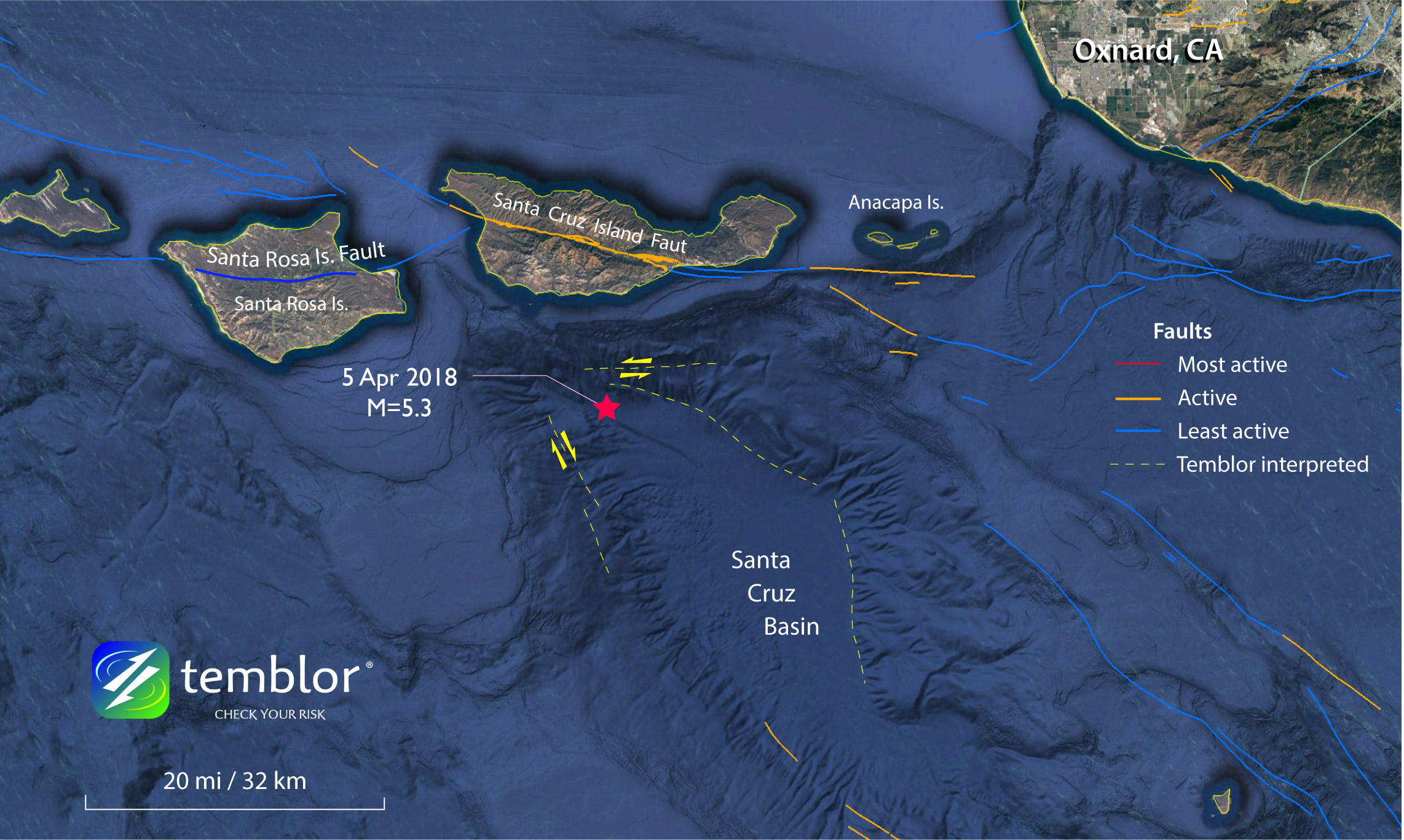
In the Temblor map above, the epicenter of today’s M=5.3 earthquake is show, as well as mapped USGS faults, and other geomorphic features which we interpret as faults. As one can see there are seafloor structures oriented north-south, and east-west, which match both potential orientations of slip. What should be pointed out is that while our interpreted faults appear extremely clear, it does not mean that they are highly active. Because erosion rates are so low underwater, faults tend to be immaculately-preserved. The location of today’s quake is also of note because it struck in the corner of the Santa Cruz Basin. Corners like this where faults meet are places where stress gets concentrated and therefore they are often places where large earthquakes start or stop. Nevertheless, the Santa Cruz Island fault and the Santa Rosa Island fault are more major features.

Geophysicist Mark Legg commented, “About every six years there’s been a M5+ offshore southern California. There was a M=6.0 in 1981 nearby. In this intersection area, which marks the boundary between the inner and outer continental borderland, there are many faults. The Santa Cruz Basin itself was ripped from Baja California and shoved northwest by the San Andreas shear zone. The Basin is ramming into the Transverse Ranges, marked by the Santa Cruz and Santa Rosa Islands, which have been caught in the shear zone and spun like ball bearings.”
References
USGS
Legg, M. R., M. D. Kohler, N. Shintaku, and D. S. Weeraratne (2015), High resolution mapping of two large-scale transpressional fault zones in the California Continental Borderland: Santa Cruz-Catalina Ridge and Ferrelo faults, J. Geophys. Res. Earth Surf., 120, 915–942, doi:10.1002/2014JF003322.
- Beware quiet segments of the Philippine Fault - May 16, 2025
-
ډیری عوامل افغاني ټولنې د زلزلې پر وړاندې زیانمنوي
- August 11, 2022 - What’s happening this week in Humboldt County, California: The squeeze - February 6, 2019