By David Jacobson, M.Sc. and Ross Stein, Ph.D., Temblor

Large quake strikes Northern Alaska
Over the weekend, Alaska’s North Slope was struck by the largest earthquake ever recorded in the region. The M=6.4 shock occurred within the Arctic National Wildlife Refuge, an area with protected status currently under threat from companies that seek to drill for oil and gas in the region. While few people inhabit this northern region, oil production workers around Prudhoe Bay to the north felt the quake. Fortunately there were no reports of damage to any structures or oil pipelines.

Potential for larger quakes
Sunday’s quake struck underneath the Sadlerochit Mountains north of the Brooks Range. These mountains are an upwarped fold, likely caused by an underlying ‘blind’ thrust fault that has steadily uplifted the fold above the coastal plain. However, while a thrust fault is likely responsible for the formation of these mountains, Sunday’s quake was strike-slip in nature. According to the Alaska Earthquake Center operated by the University of Alaska Fairbanks and the USGS, strike-slip events are common in the Brooks Range.

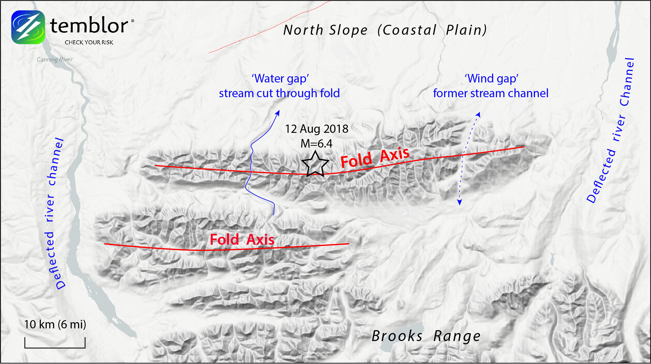
We suspect that the M=6.4 quake and its principle aftershocks struck on a ‘tear fault’ along the thrust. Based on the fold length, the thrust itself would have a dimension of 50 x 40 km, and so is capable of a M~7.3 quake, much larger than the 12 August event. Earthquakes on blind thrust faults caused the M=6.7 Coalinga, CA, quake in 1983, and the M=7.3 El Asnam, Algeria, quake in 1980.
A surprising earthquake
While a strike-slip fault rupturing in this region is not considered surprising, the magnitude of Sunday’s quake is. Prior to the M=6.4, the largest quake ever recorded in the region was a M=5.2 in 1995. So, this quake was over 50 times greater than the previous largest quake. Because of this, state seismologist Mike West said that, “it’s safe to say this earthquake will cause a re-evaluation of the seismic potential of that area.”

The Global Earthquake Activity Rate (GEAR) model, which is available in Temblor, further supports the inference that Sunday’s quake was unexpectedly large. This model uses global strain rates and the last 40 years of seismicity to forecast the likely earthquake magnitude in your lifetime anywhere on earth. From the model, which can be viewed here, one can see that the model doesn’t pick up a large earthquake risk in the region. So, quakes on the blind thrust faults are uncommon, but possible.
Arctic National Wildlife Refuge under siege
Any changes to the seismic hazard of the North Slope could potentially impact drilling operations currently in place, as well as aspirations to drill in the Wildlife Refuge. Only last month, the Interior Department expedited an environmental review of the impacts leasing part of the Arctic National Wildlife Refuge for oil drilling could have. The administration is rapidly moving forward as it seeks to open the coastal plain to energy exploration. Environmentalists are concerned that drilling could significantly impact the polar bears, caribou, and waterfowl in the refuge, which has enjoyed government protection for decades. This quake underlies another drilling risk: Induced earthquakes that could increase the shaking in the region, as has happened in Oklahoma since extensive drilling began there in about 2003. According to the Washington Post, should the Arctic Refuge leases are approved, two plots of land, each 400,000 acres would be open to drilling by 2024.
References
USGS
Alaska Earthquake Center
Yahoo News
Washington Post
- Beware quiet segments of the Philippine Fault - May 16, 2025
-
ډیری عوامل افغاني ټولنې د زلزلې پر وړاندې زیانمنوي
- August 11, 2022 - What’s happening this week in Humboldt County, California: The squeeze - February 6, 2019