A magnitude-6.4 earthquake struck off the seismically active coast of Northern California, not far from Eureka, on Tuesday, Dec. 20.
By Temblor Editorial Team, (@temblor)
This is story was updated on Thursday, Dec. 22 at 1:oo p.m. local time to reflect updated information.
At 2:34 a.m. local time on Dec. 20, a magnitude-6.4 earthquake struck off the coast of Northern California. The epicenter was about 9 miles (15 kilometers) southwest of Ferndale, California, which is 19 miles (31 kilometers) south of Eureka. The quake, which was 11 miles (17.9 kilometers) deep, jolted people awake and caused extensive power outages and widespread damage, especially to roads and gas and water lines. Dozens of houses were damaged with at least 30 being deemed structurally unsafe, according to news reports. No tsunami occurred. Aftershocks continue in the region. Two people have died from medical emergencies during or right after the quake and at least 12 were injured. California officials are warning people to inspect their gas and water lines carefully for damage. The Sacramento Bee has a great primer on what and how to check.
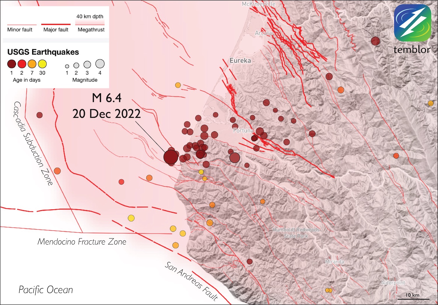
This region is incredibly tectonically active, thanks to the junction of three tectonic plates (called a triple junction): the North American Plate, the Pacific Plate and the Juan de Fuca Plate. The place where the three meet is where the northern tip of the San Andreas Fault interacts with the Mendocino Fracture Zone (a transform fault) and the Cascadia Subduction Zone, which is capable of megathrust (including magnitude-9-plus) earthquakes.
This “crunch zone” where the Juan de Fuca Plate slams into North America from the west results in a subduction zone where the Juan de Fuca Plate cannot go smoothly down the hatch because of a space problem (Silver, 1971), says Ross Stein, CEO of Temblor and publisher of Temblor Earth News (TEN), who also wrote an analysis for TEN of this region in 2019. “The downgoing plate is deformed into a wide band of faults, one of which likely fired off,” Stein says. “An earthquake of this size is expected in one’s lifetime if they live in the Eureka area. So, this is not unexpected or unusual,” Stein adds.

In fact, a magnitude-6.2 earthquake occurred about 12 miles (20 kilometers) away a year ago today. In the last century, earthquakes above magnitude 7 and more than 40 quakes above magnitude 6 have struck within 155 miles (250 kilometers) of today’s temblor.

Preliminary analysis by the U.S. Geological Survey (USGS) suggested that the Dec. 20 earthquake occurred “as a result of strike-slip faulting on a steeply dipping fault,” likely within part of the Gorda Plate, which is part of the Juan de Fuca Plate that subducts beneath Northern California, Oregon and Washington.
Further analysis after the quake suggests it was a left-lateral strike-slip event, which is opposite of what some scientists thought initially, based on the focal mechanism (or beachball diagram) coupled with the orientation of faults that have been previously mapped in the region. The mapped faults all strike in one direction (northwest), but this quake seemed to have struck in the opposite direction (northeast).
#EarthquakeReport for M 6.4 #Earthquake in Mendocino triple junction (Triangle of Doom) region
aftershocks suggest left-lateral strike-slip in Gorda plate
felt broadly, about 92%g in Ferndale
read more from last year's reporthttps://t.co/aS9ySrs7WXhttps://t.co/9HKHnpMFSh pic.twitter.com/wt4UduAuvt
— Jason "Jay" R. Patton (@patton_cascadia) December 20, 2022
“Despite the extensive fault mapping by the best in the business, this magnitude-6.4 shock appears to have struck on a left-lateral fault,” which was unmapped, Stein says. “Earthquakes humble us [as scientists],” he says.
Many aftershocks extended east of the mainshock. Shaking has been felt from Seattle through Oregon to the north, and south to San Jose.
Although the quake struck offshore, the rupture propagated toward the northeast, continuing onshore and thus under some of the towns of Humboldt County, California, wrote seismologist Lucy Jones on Twitter.
What can we see about the M6.4 from current data? The aftershocks trend NE which matches on of the focal mechanism planes. The fault for a M6.4 can be ~20 km long. It looks like the quake began offshore but then ruptured to the NE, so places like Rio Dell are on top of the fault. https://t.co/FOBEu7R9aG
— Dr. Lucy Jones (@DrLucyJones) December 21, 2022
If you’re in the region, stay alert. If you feel shaking, remember to Drop, Cover and Hold On, as per the USGS guidelines. And once it’s safe to do so, report the shaking you felt to USGS’s Did You Feel It? website. Almost 6,000 people reported feeling shaking from the magnitude-6.4 quake; aftershocks are tracked separately, so if you feel shaking from an aftershock, report that as well.

More than 3 million people across California and Oregon received alerts of the shaking from Android Earthquake Alerts, the MyShake app, or other earthquake early warning apps at 2:34 a.m. Dec. 20. The warnings told people nearby, including in the San Francisco Bay area, to Drop, Cover and Hold On. If you’re in California, Oregon and Washington, download the MyShake app on your smartphone to get early warning alerts of shaking in your area. If you have an Android smartphone, the feature is native, so no need for any apps to receive a warning (See this TEN article for more about MyShake and Android Earthquake Alerts).
References
Eli A. Silver (1971), Tectonics of the Mendocino Triple Junction, Geological Society of American Bulletin, 82, 2965-2978, doi.org/10.1130/0016-7606(1971)82[2965:TOTMTJ]2.0.CO;2
- Venezuela’s doublet leaned toward Caracas - June 30, 2026
- Is Southern California’s Cajon Pass an ‘earthquake gate’ ready to open? - June 29, 2026
- Philippines magnitude 7.8 shock may have loaded the central Cotabato subduction zone - June 11, 2026