The Cotabato Trench, and perhaps the southernmost Mindanao Fault, may be closer to failure as a result of the magnitude 7.8 mainshock.
By Ross Stein, Temblor, Inc. and Shinji Toda, Tohoku University
Citation: Stein, R.S., & Toda, S., 2026, Philippines magnitude 7.8 shock may have loaded the central Cotabato subduction zone, Temblor, http://doi.org/10.32858/temblor.377
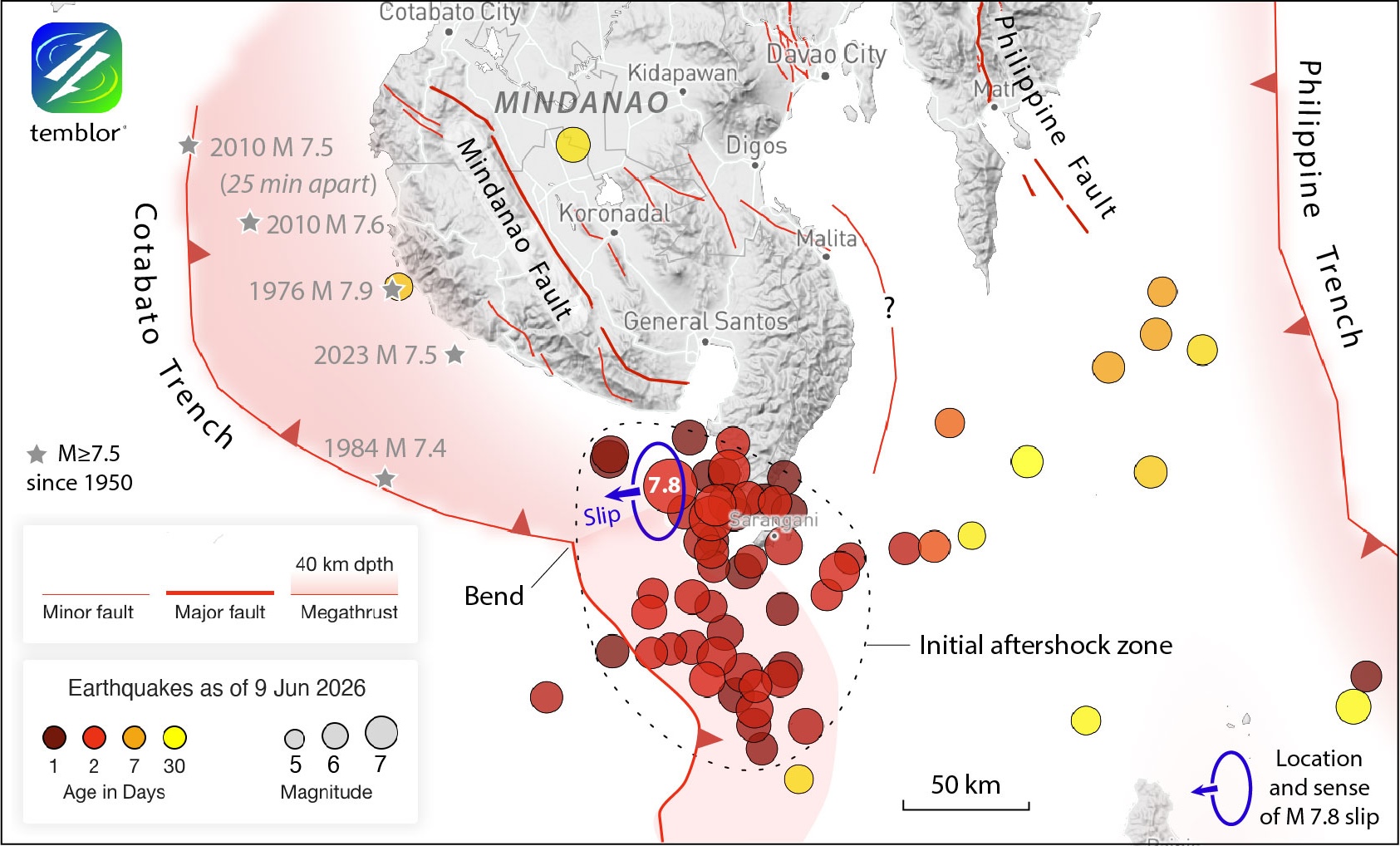
The largest Philippines shock in a half century — a magnitude 7.8 event — struck an earthquake-weary country on June 7, 2026, shaking the southernmost island of Mindanao. As of this writing, the Philippines authorities are reporting 47 deaths, several building collapses, and extensive building and infrastructure damage in General Santos City, which lays 55 kilometers (35 miles) north of the epicenter (Figure 1). In addition, a tsunami of 0.5 meters struck Davao City. Fortunately, the 55 kilometer depth of the quake, and its location 25 kilometers offshore, reduced its tsunami potential and its peak shaking intensity on land.
In this work, we try to understand what caused the quake and what might come next.
More questions than answers
The mainshock is associated with the Cotabato subduction zone, but how? Hubbard and Bradley (2026) argue that it’s probably too deep to have struck on the megathrust interface — the surface on which most great earthquakes, and virtually all with magnitudes of 8.4 or greater, strike. However, the aftershock distribution, which extends more than 100 kilometers south from the epicenter, parallel to the trench (Figure 1), seems more compatible to us with the quake occurring on the megathrust interface.
The earthquake resulted from thrust (contractional) motion, as expected in a subduction zone. In a typical subduction zone, most events slip perpendicular to the trench.
The USGS finite fault model (USGS, 2026) indicates a slip direction nearly perpendicular to the section of the Cotabato Trench south of the epicenter (the slip vector is shown as a blue arrow in Figure 1). However, the earthquake struck near a sharp bend in the trench (labeled as ‘bend’ in Figure 1). Northwest of the epicenter, the orientation of the trench is inconsistent with the slip vector.
Aftershocks have lit up much of the section to the south. This leaves the adjacent 70 to 100-kilometer section of the trench unruptured at least since 1950, and probably since 1918, when a magnitude 8.3 shock struck there (Llamas et. al, 2026).
A ferocious decade of large earthquakes
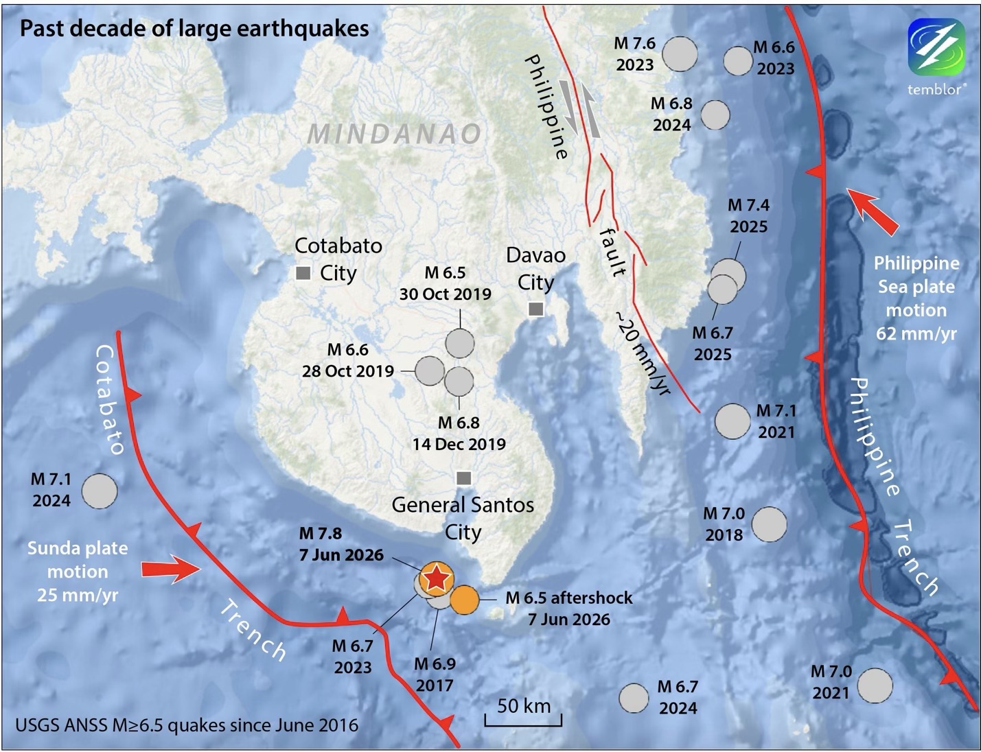
There have been 17 magnitude 6.5 and larger shocks; seven of these, with magnitude 7.0 or larger, in the past decade (Figure 2). Compare that record to that of southern California, well known earthquake country covering about the same area. During the same period, Southern California experienced just one shock larger than magnitude 6.5 — the 2019 magnitude 7.1 Ridgecrest event.
The difference between these regions is that Mindanao, as well as most of the Philippine archipelago, is caught in a massive tectonic vice. The Philippine islands are compressed between opposing subduction zones, and sliced by a major San Andreas-like transform fault, the Philippine Fault. Although Southern California and Mindanao are both being sheared by about 50 millimeters per year, Mindanao is also compressed at about 50 millimeters per year (Figure. 2).
Another characteristic of the past decade of large shocks in the southern Philippines is the preponderance of clusters. A magnitude 6.9 shock in 2017 and a magnitude 6.7 shock in 2023 struck in the epicentral region of the magnitude 7.8 mainshock. In retrospect, we might dare to call these foreshocks, but nothing that we know about them marked them for future greatness. A forensic analysis of those shocks will certainly be explored by other researchers.
Three quakes (four if one includes a magnitude 6.4 shock) struck closely in time and space just north of General Santos City in 2019 (Tripathy-Lang, 2019). Northeast of Davao City, three large shocks struck in close proximity during 2023 and 2024, although the second two could be regarded as aftershocks of the first and largest quake (Figure 2).
If we look back even further, we see similarly clustered earthquakes. For example, a pair of magnitude 7.5 and 7.6 shocks struck 25 minutes and 30 kilometers apart in 2010 (Figure. 1).
Vigorous swarms have also recently occurred along the Cotabato Trench (Llamas et al., 2026). The Palimbang earthquake swarm began in 2025, and the Kalamansig earthquake swarm commenced in 2026.
What could happen next?
Although there is much (too much) we don’t know about this earthquake, it is not too soon to ask where the next large shocks could strike, particularly given the propensity for earthquake sequences in the Philippines. Plus, because aftershock rates are highest in the days after a mainshock, triggering is more likely now than later. Fortunately, no aftershocks have struck within 50 kilometers of the already strongly-shaken General Santos City. Thus far, aftershocks extend 100 kilometers to the south of the epicenter and about 50 kilometers to the east.
In the upper panel of Figure 3, we resolve the Coulomb stress change on faults parallel to the mainshock. Although all faults will not be parallel to the source fault, it’s a good starting point.
Early aftershocks are associated with the region of calculated Coulomb stress increase (red zones). A stress shadow (blue zone) 50 kilometers west of the mainshock does not contain aftershocks. So though oversimplified, Figure 3’s upper panel bears some resemblance to the distribution of early aftershocks.
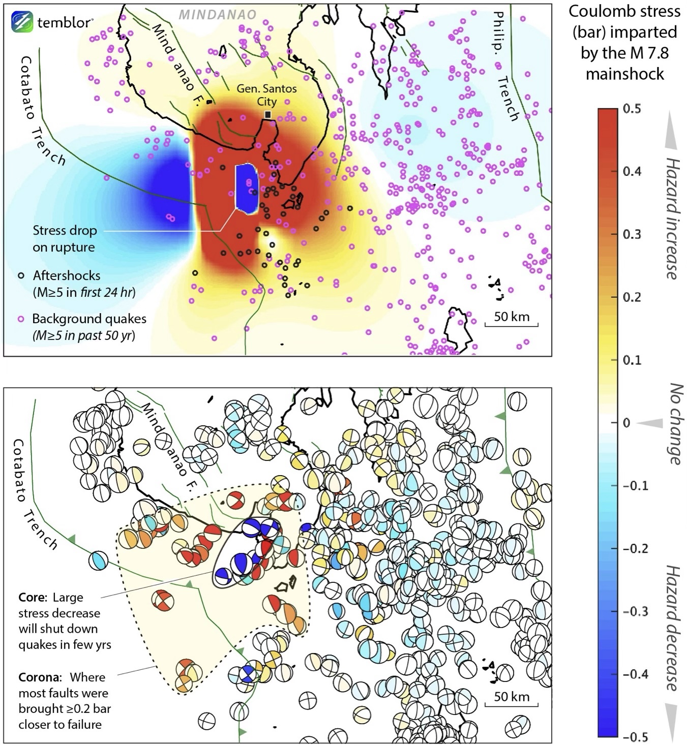
In reality, faults with myriad orientations and sizes slice nearly the entirety of Earth’s crust, and the faults surrounding the rupture are unlikely to be parallel to it. To capture that variability, we calculate stress imparted to the faults that have slipped in earthquakes greater than or equal to magnitude 5 over the past 50 years. These faults are represented by their moment tensors (also known as focal mechanisms, or beachballs) in the lower panel of Figure 3. Here, we are testing whether faults that we know exist (because they have ruptured in the past) are brought closer to or farther from failure by the magnitude 7.8 shock. But because moderate quakes have not occurred everywhere, the picture is discontinuous. Also, faults with different depths, strikes, dips, and rakes (sense of slip) can be juxtaposed, so adjacent stress changes can be inconsistent.
We see a central core (outlined as an ellipse in Figure 3, lower panel) that roughly coincides with the site of fault slip. In the core, the beachballs are blue. Based on Toda and Stein (2022), we would expect that within 5 years, the core will completely shut down, forming an aftershock hole.
Surrounding the core is a corona, much larger than the core, where the stress has risen on most of the surrounding faults. Based on Toda and Stein (2022), we expect the corona to continue to produce aftershocks, and potentially subsequent mainshocks, over the next 30 or so years, but with the frequency of aftershocks rapidly decaying.
The Cotabato Trench’s future
The big difference between the forecasts in the upper and lower panels of Figure 3 is the section of the Cotabato subduction zone to the northwest of the magnitude 7.8 mainshock. In the upper panel, it is largely in a (blue) stress shadow, whereas in the lower panel it is in a (red) stress trigger zone.
We propose the lower panel is closer to the truth because the orientations of beachballs are uniform and consistent with the subduction direction. In other words, the Cotabato Trench, and perhaps the southernmost Mindanao Fault, have been brought closer to failure by the magnitude 7.8 mainshock. We can also see that during the past 75 years, the 100-kilometer span of the Cotabato Trench adjacent to the 2026 magnitude 7.8 shock has not ruptured. With the approximately 25 millimeter per year plate convergence along the Cotabato Trench, at least 2 meters or so of slip has already accumulated and is expected to be released during the next earthquake. Thus, this gap could be filled by another magnitude 7.6 to 7.8 event in the future. The lower bound, magnitude 7.6, is an empirical estimate based on the fault surface area that has not ruptured since 1950, based on scaling relations of Blaser et al. (2010). Our estimate is also influenced by the size of past quakes on this trench, including a well-studied magnitude 7.9 earthquake in 1976 (Beck and Ruff, 1985).
However, the counter-argument to our interpretation is that aftershocks have not yet struck on the Cotabato megathrust section that we calculate to be loaded, which might be expected had this section been turned on by the mainshock. Why not? We don’t have an adequate answer to this good question, and so it’s important that we speak with humility rather than finality as we watch the aftershock sequence unfold.
Closing thoughts
This highly destructive earthquake has puzzling attributes that might be disentangled by further study. What’s clear is that the mainshock was preceded by large foreshocks over the past decade, and has been followed by aftershocks extending well to the south of the rupture zone, but not to the north. Although our calculations suggest that the adjacent 100 kilometers of the Cotabato Trench has been brought closer to failure, thus far this section has not lit up with aftershocks, deepening the mystery.
Science Editor: Alka Tripathy-Lang
References
Beck, S. L., Ruff, L. J., 1985, The rupture process of the 1976 Mindanao earthquake, Journal of Geophysical Research: Solid Earth, 90(B8), 6773–6782, http://doi.org/10.1029/JB090iB08p06773
Blaser, L., Krüger, F., Ohrnberger, M., Scherbaum, F., 2010, Scaling relations of earthquake source parameter estimates with special focus on subduction environment, Bulletin of the Seismological Society of America, 100(6), 2914–2926, http://doi.org/10.1785/0120100111
Hubbard, J. A., Bradley, K., 2026, Deadly M7.8 earthquake rocks southern Philippines, Earthquake Insights
Llamas, D. C. E., Mangahas-Flores, R., Acid, J. J. S., Naing, J. P. S., 2026, Are earthquake swarms along the Cotabato Trench echoes of a 1976 magnitude 8.1 quake?, Temblor, http://doi.org/10.32858/temblor.375
Ohkura, T., Tabei, T., Kimata, F., Bacolcol, T. C., Nakamura, Y., Luis, A. C., Jr., Pelicano, A., Jorgio, R., Tabigue, M., Abrahan, M., Jorgio, E., Gunawan, E., 2015, Plate convergence and block motions in Mindanao Island, Philippines, as derived from campaign GPS observations, Journal of Disaster Research, 10(1), 59–66, http://doi.org/10.20965/jdr.2015.p0059
Toda, S., Stein, R. S., 2022, Central shutdown and surrounding activation of aftershocks from megathrust earthquake stress transfer, Nature Geoscience, 15, 494–500, http://doi.org/10.1038/s41561-022-00954-x
Tripathy-Lang, A., 2019, Four large quakes in two months jolt southern Philippines, Temblor, http://doi.org/10.32858/temblor.059
U.S. Geological Survey, 2026, M 7.8 – 26 km SW of Kablalan, Philippines, finite fault model v.1, https://earthquake.usgs.gov/earthquakes/eventpage/us7000srb1/executive
Yoshizawa, K., Toda, S., Stein, R. S., Sevilgen, V., Lin, J., 2026, Introducing Coulomb 4.0: Enhanced stress interaction and deformation software for research and teaching, Temblor, http://doi.org/10.32858/temblor.372
Copyright
Text © 2026 Temblor. CC BY-NC-ND 4.0
We publish our work — articles and maps made by Temblor — under a Creative Commons Attribution-NonCommercial-NoDerivatives 4.0 International (CC BY-NC-ND 4.0) license.
For more information, please see our Republishing Guidelines or reach out to news@temblor.net with any questions.
- Venezuela’s doublet leaned toward Caracas - June 30, 2026
- Is Southern California’s Cajon Pass an ‘earthquake gate’ ready to open? - June 29, 2026
- Philippines magnitude 7.8 shock may have loaded the central Cotabato subduction zone - June 11, 2026