By Alka Tripathy-Lang, Ph.D. (@DrAlkaTrip)
In the past two months, four quakes between magnitude-6.4 to -6.8 ruptured southwest of Mount Apo, a quiet stratovolcano near Davao City, in the Philippines. The third of these large temblors was potentially volcanic in origin, and the most recent earthquake was the largest, striking a region already reeling from the three previous events and their aftershocks.
Citation: Tripathy-Lang, Alka (2019), Four large quakes in two months jolt southern Philippines, Temblor, http://doi.org/10.32858/temblor.059
In March 1991, on the northern Philippine island of Luzon, a sleepy, lushly vegetated beast began to shake itself awake from a 500-year slumber. Mount Pinatubo’s warning signals began when earthquakes jostled nuns living on its flanks. Scientists at the Philippine Institute of Volcanology and Seismology (PHIVOLCS) sprang into action soon after. With the help of the U.S. Geological Survey (USGS), the researchers deployed portable seismometers to monitor the burgeoning unrest. As activity increased, PHIVOLCS began to evacuate the local population, with about 58,000 people eventually removed from harm’s way (Wolfe and Hoblitt, 1996).
On the afternoon of June 15, 1991, Mount Pinatubo unleashed the second-largest volcanic eruption of the 20th century. Tens of thousands of lives were saved, and the actions of PHIVOLCS in conjunction with the USGS have been heralded as an example of successful volcanic forecasting (Tayag et al., 1996).

Today, PHIVOLCS continues to monitor volcanoes and earthquakes—hazards inherent to a nation built on an archipelago of volcanoes sitting atop a subduction zone. Recently, the organization has had to contend with a curious set of earthquakes near another volcano that has not been obviously active in the recent past. Whether the quakes are merely tectonic—or are being triggered by a volcano that is perhaps awakening—is unknown.
A trio of temblors
On Oct. 16, 2019, a magnitude-6.4 earthquake rocked the southern Philippine island of Mindanao, causing landslides and collapsing buildings in the immediate region, according to PHIVOLCS. On Oct. 29, a M 6.6 earthquake struck only 25 kilometers to the northeast. Two days later, a third large earthquake, this one M 6.5, struck about 10 kilometers to the northeast of the second, with both later events wreaking havoc on an already reeling local population. The National Disaster Risk Reduction and Management Council of the Philippines reported that 23 people were killed, 563 were injured, and 11 are missing, with the dead ranging in age from 6 months to 91 years. Causes of death include landslides, falling debris, cardiac arrest, and other earthquake-related traumas.


Although the locations of the first three earthquakes follow a northeast trend, PHIVOLCS reports that they occurred on the Cotabato fault system, a series of predominantly northwest-southeast trending faults. The Cotabato fault system shows left-lateral strike-slip motion, according to a USGS Scientific Investigations Report. During strike-slip faulting, the two sides of a fault move past each other along a near-vertical fault plane.
GIF of left-lateral strike-slip fault, showing how a near-vertical fault plane moves, causing the opposite side of the fault to move to the left. This is true no matter which side of the fault an observer is standing, hence the term “left-lateral.” Credit: Incorporated Research Institutions for Seismology (IRIS).
A fourth shock
On Dec. 15, 2019, a M 6.8 earthquake jolted the same region. Just a few tens-of-kilometers southeast of the track of the October temblors, this event was the largest of the set of four quakes, and three people, including a 6-year-old girl, have been killed. Because structures were already weakened by the October earthquakes, damage is likely to be even more significant.
A different kind of quake
PHIVOLCS reports that all three October earthquakes were tectonic, which means that one side of the fault plane moved past the other because tectonic stress needed to be released. However, the Oct. 31 M 6.5 earthquake may be more complicated.
For earthquakes greater than M 5.0, scientists use seismic waves produced by the earthquake, measured at multiple seismic stations, to calculate a “moment tensor,” which is a mathematical representation of how a fault moves during an earthquake. Simple tectonic earthquakes typically involve movement along a planar surface. One side moves past the other, and this is clear in the moment tensor solution. Gavin Hayes, a research geophysicist at USGS who calculates and verifies moment tensors, says that more complicated seismic events instead involve movement of curved faults, or multiple planes that are not perpendicular to one another; such multi-planar behavior is evident from the moment tensor solutions he calculates. These types of seismic events have myriad causes, including volcanic eruptions, landslides, fluid migration, and highly complex tectonic earthquakes, he says.
The Oct. 31 M 6.5 earthquake has an astoundingly high level of multi-planar behavior, as reported by the USGS. Hayes examines each multi-planar event in more detail than simple tectonic quakes, and for this particular earthquake, the degree to which it could be described as a single plane versus multi-planar varies. However, he notes that another repository of moment tensors calculated using a different method, the Global Centroid Moment Tensor Catalog (gCMT), “also has a large-ish [multi-planar] component for this earthquake.” In other words, both the USGS and gCMT algorithms arrive at a similar moment tensor solution that indicates this event was unlikely to be a typical tectonic temblor.
The most recent Dec.15 M 6.8 quake also has a higher-than-usual level of multi-planar behavior, as reported by the USGS, although not as high as the Oct. 31 event.
Rarity of large volcanic quakes
In an area replete with volcanoes, like the Philippines, a common question is whether earthquakes are linked with volcanic activity. Hayes notes that “While large [multi-planar] components in volcanic earthquakes are possible … very large volcanic earthquakes are rare.”
Hayes hypothesizes that assuming a simple tectonic earthquake is not a bad assumption, in most cases. “While large [multi-planar] components in volcanic earthquakes are possible … very large volcanic earthquakes are rare.”
Jackie Caplan-Auerbach, a seismologist at Western Washington University who studies seismic signals associated with volcanoes and landslides, agrees. “It’s not unheard of that volcanoes will have larger events that are off to the side. [But] a bunch of tiny earthquakes is more alarming than a few big ones, and there’s not a clear link between tectonic earthquakes and volcanic eruptions,” she says.
In other words, large earthquakes are usually tectonic, and when looking for seismic indicators of volcanic activity, small earthquakes below a volcano are more important than nearby big ones.
Tiny temblors under a quiescent volcano
According to PHIVOLCS, the nearest active volcanoes to these earthquakes are Matutum Volcano (~46 kilometers away) and Parker Volcano (~76 kilometers away), both of which are to the southwest, in the opposite direction of the propagation of the quakes. However, Ross Stein, geophysicist and CEO of Temblor, notes that these earthquakes “seem to be propagating toward volcanoes Mount Apo and Mount Talomo,” neither of which is active, according to PHIVOLCS.

Mount Talomo is listed as inactive, and Mount Apo as “potentially active,” which PHIVOLCS defines as “morphologically young-looking, but with no historical or analytical records of eruption.” Mount Apo also emits sulfurous gases and supports a geothermal energy production facility, but otherwise, it quietly watches over Davao City, the third-most populous city in the Philippines.
Stein says that because the volcanoes are about 15 kilometers northwest of the third, “peculiar” earthquake, “I would not expect seismicity there to be tectonic aftershocks, but, instead, events related to the volcano that were stimulated by the quake.” And indeed, Stein and Temblor scientist Geoffrey Ely found just that. “By permission from PHIVOLCS, Temblor pings the PHIVOLCS catalog every minute, and shows the past month of their quakes in the app.”
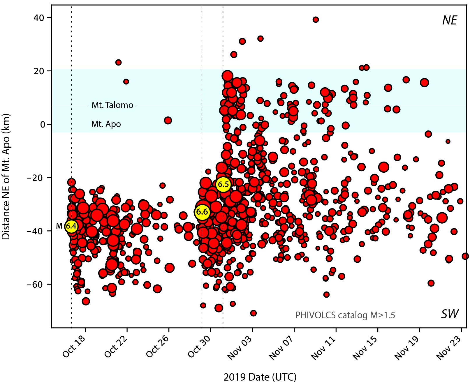
In this time series, the first quake (M 6.4) shows the expected mainshock-aftershock sequence typical of tectonic earthquakes, with aftershocks decreasing over time. The second quake (M 6.6) similarly does not appear to trigger any seismicity in the blue band. However, the third quake (M 6.5) appears to have provoked many small earthquakes underneath the volcanoes, which, Stein says, is to be expected for a waking volcano. The fourth quake is not included in this analysis.
Peggy Hellweg, a seismologist at the Berkeley Seismology Lab who has experience with volcano-tectonic earthquakes, says, “the nearby magnitude 6.5 triggered some unrest at the volcano, based on seismicity under it starting at that time. Whether it will erupt or not is a completely different question.” She says that based on the time series, any unrest is quieting down, and to ascertain whether this behavior is normal or anomalous, “it would certainly be great to see a much longer seismicity time series.”
December quake analysis
The December earthquake may come as no surprise to those who live in the Philippines. However, for earthquake scientist Wendy Bohon, four earthquakes between M 6.4-6.8, though not unprecedented, is unusual. She says “I’d be interested to see if that’s typical behavior of those fault systems, or if we have records far enough back to determine that.” Using the IRIS Earthquake Browser, which plots earthquakes recorded by the Global Seismographic Network and located by the USGS since 1970, she notes that these four M 6.4-6.8 quakes are the only large events in the region southwest of Davao City in the USGS catalog.
Paleoseismology investigations, where scientists dig trenches along a fault to find evidence of past movement, have not been published, so much of this area’s earthquake history is hidden beneath basin sediments, which, according to Bohon, are particularly hazardous because of liquefaction concerns.
Nevertheless, the four temblors and their aftershocks are clearly signaling that something is going on that merits close attention.

PHIVOLCS disaster response
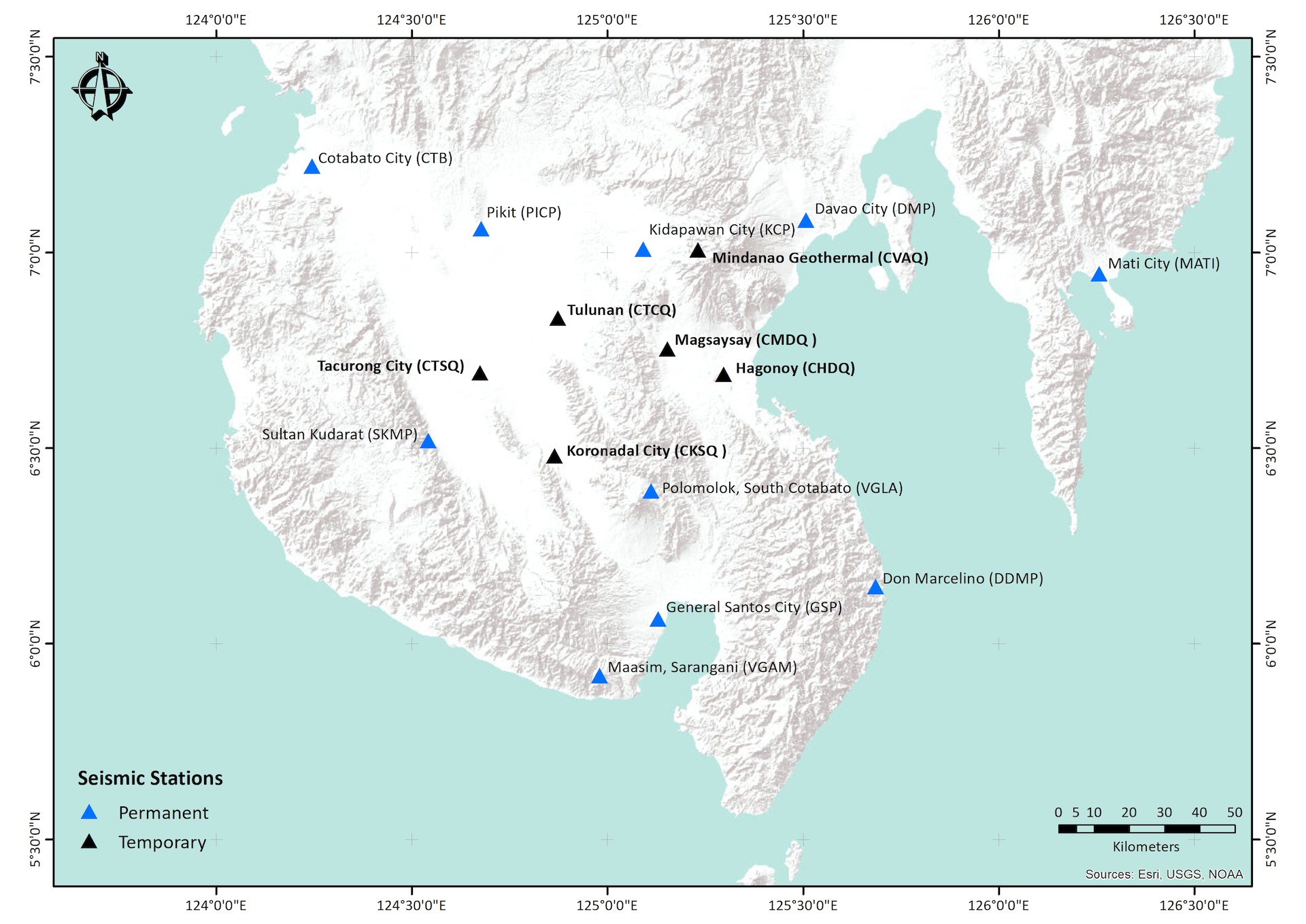
After the first three earthquakes, PHIVOLCS increased its monitoring efforts near Matutum and Parker, the known active volcanoes in the opposite direction. Also, after the October shocks, they sent a quick response team that, in addition to assessing damage, established portable seismic stations near the earthquake epicenters, which included an additional station on Mount Apo.
Further, according to a PHIVOLCS media release, their quick response teams are engaging in both earthquake and volcanic hazard assessment and conducting informational campaigns to calm the local population. Their immediate concerns focus on aftershocks and their potential to remobilize landslides, cause flash floods and precipitate liquefaction, among other seismic hazards. This is expected, considering there is no clear threat from any nearby volcano, and will likely continue in the aftermath of the December earthquake.
“It’s something”
Caplan-Auerbach says that the earthquakes progressing toward Mount Apo are intriguing, and the question of whether there is any indication of volcanic unrest is a reasonable one. However, she says, “there’s no [historic] record of [these volcanoes] doing anything. That’s the challenge.”
On the other hand, Stein says, “the least astonishing conclusion is that all three [October earthquakes] were strike-slip events, but the third nevertheless ‘turned on’ the volcano, perhaps because it was a little closer. The alternative is that the third quake was a volcanic event, which would account for its ability to trigger volcano seismicity. It’s very hard to avoid the interpretation that there is some volcanic interaction going on here.”
The multi-planar component of the third earthquake “may be real,” Hellweg says, pointing out that “although it looks like the seismicity is dying down, you never know what the volcano will do next.” Volcanic eruption forecasting is difficult for this exact reason.
Perhaps these volcanoes are simply tossing and turning in their otherwise deep sleep. As yet, scientists do not have any indicators that an eruption is imminent from any of the volcanoes mentioned here. Yet, Stein says, “there’s a lot of strange things here, and it’s something.”
References
Tayag, J., Insauriga, S., Ringor, A. and Belo, M. (1996). “People’s Response to Eruption Warning: The Pinatubo Experience, 1991-1992,” in Fire and Mud: Eruptions and Lahars of Mount Pinatubo, Philippines, eds C. G. Newhall and R. S. Punongbayan (Quezon; Seattle, WA: Philippine Institute of Volcanology and Seismology and University of Washington Press), 87-106.
Wolfe, E. W., and Hoblitt, R. P. (1996). “Overview of the eruptions,” in Fire and Mud: Eruptions and Lahars of Mount Pinatubo, Philippines, eds C. G. Newhall and R. S. Punongbayan (Quezon; Seattle, WA: Philippine Institute of Volcanology and Seismology and University of Washington Press), 3–20.
Note: This article was first posted on December 11, 2019, but has been revised on December 15, 2019 to reflect a fourth large earthquake in this region.
- Living through the Loma Prieta earthquake - October 21, 2021
- The Great Quake Debate: an interview with seismologist and author Susan Hough - August 27, 2020
- Salton Sea Swarm quiets down - August 12, 2020