Two earthquakes greater than magnitude 7 and less than a minute apart broke the same right-lateral fault west of the capital. The physics of how they ruptured concentrated stress in the one direction Caracas cannot ignore.
By Esteban J. Chaves, Ph.D., Observatorio Vulcanológico y Sismológico de Costa Rica, Universidad Nacional (OVSICORI-UNA), Ross Stein, Ph.D., Temblor, Inc., Shinji Toda, Ph.D., Tohoku University
Citation: Chaves, E. J., Stein, R. S., and Toda, S., 2026, Venezuela’s doublet leaned toward Caracas, Temblor, http://doi.org/10.32858/temblor.379
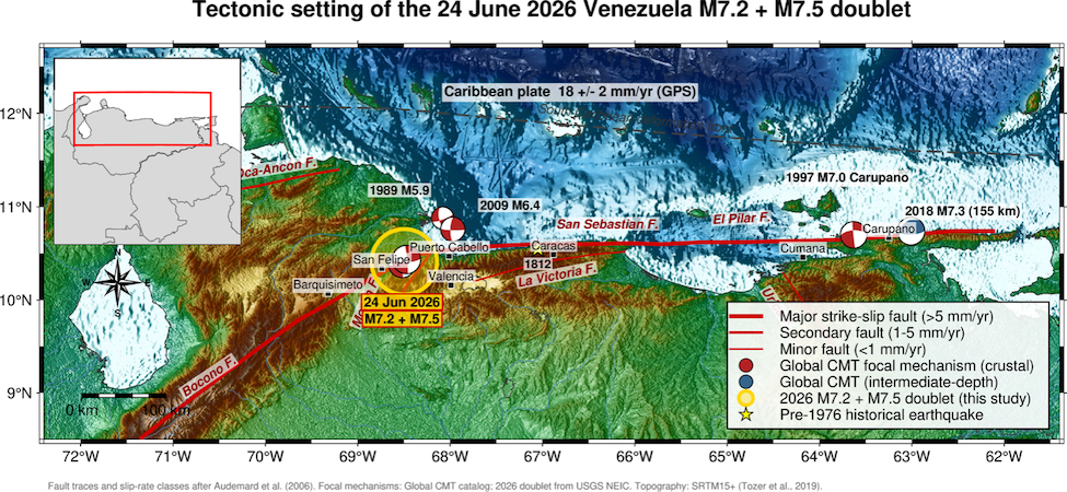
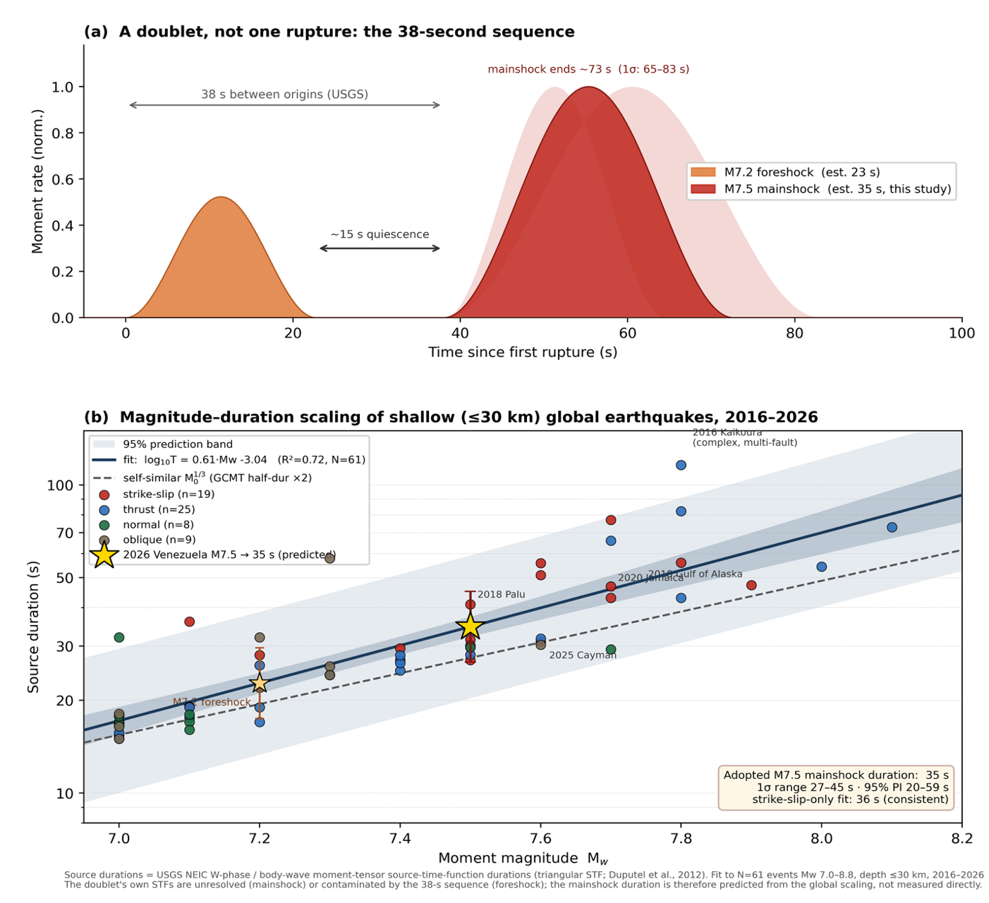
At 18:04 (6:04 p.m.) local time on June 24, 2026, the coast of north-central Venezuela moved — twice. A magnitude 7.2 earthquake struck beneath the hills southeast of Yumare, between the towns of San Felipe and Morón (Figure 1). Thirty-nine seconds later, before the first rupture’s shaking had cleared the region, a magnitude 7.5 earthquake broke a few kilometers to the east. At least 2,300 people have died though the death count may end up far higher.
The U.S. Geological Survey issued red PAGER alerts for both, meaning high casualties, extensive damage and economic loss were probable; modeled shaking reached intensity IX (violent). Not since the likely offshore event of 1900, with a magnitude of around 7.7, has Venezuela been struck this hard. Within hours, the word attached to the sequence was “doublet,” and some early news coverage asked whether the country had instead suffered a single large earthquake split in two.
It had not. And the way the two ruptures fit together — nearly identical mechanisms, a clean pause between them and a step in one direction — tells a more specific and more uncomfortable story than “a doublet struck Venezuela.” It tells us which way the stress went. It went toward Caracas.
Early analysis points toward two different ruptures
The initial magnitude 7.2 earthquake released its energy over roughly 23 seconds, an ordinary duration for an event of that size (Figure 2). Then, nothing for about 15 seconds. Only then did the magnitude 7.5 earthquake nucleate, some 7 kilometers away, lasting for an estimated 35 seconds. A continuous rupture does not idle for 15 seconds and restart 7 kilometers along strike; a triggered one does.
The first earthquake loaded its neighbor through the static stress change it imposed and the passing dynamic stress of its own seismic waves until a second, independent patch failed. Their seismic moments — the standard physical measure of an earthquake’s size — sum to about 2.8×10²⁰ N·m, the equivalent of a single magnitude 7.6 earthquake. But they were two distinct events. The gap between them is the fingerprint of stress transfer between two patches that were both already close to failure.
The same fault, twice
The earthquakes share essentially the same mechanism (Figure 1): a near-vertical, roughly east–west plane with right-lateral (dextral) slip. That orientation is not arbitrary. It is the orientation of the San Sebastián Fault, the mostly onshore strand of the boundary between the Caribbean and South American plates, which slide past one another at roughly 18 ± 2 millimeters per year (Audemard et al., 2006).
In addition, the mechanism is exactly what the regional stress field predicts. Audemard et al. (2006) describe northern Venezuela as a transpressional boundary. Transpressional systems involve oblique plate motion that results in lateral, strike-slip motion with a compressive thrust component. In this case, the regional stress field is governed by a NNW–SSE maximum horizontal stress, a stress field that organizes the region’s faults into a single shear system, in which many separate strike-slip strands accommodate the same right-lateral plate-boundary motion.
In short, the fault orientation and the regional stress field are mutually consistent. The east–west, right-lateral mechanism of both recent shocks matches the mapped trace of the San Sebastián Fault, and the rupture’s northwest–southeast compressional (P) axis — which, as it must for strike-slip, lies about 45° from the east–west fault — aligns with the NNW–SSE regional compression that Audemard and colleagues derived from hundreds of fault-plane measurements. The 2026 earthquakes broke just as a textbook of Venezuelan neotectonics says this boundary should.
So, the doublet was not two unrelated faults caught in a coincidence. It was two patches of the same right-lateral system, breaking in sequence and in step with the stress field that governs the northern coast of Venezuela as well as the plate margin.
A plate boundary braided through a coast
To see why this matters, it helps to picture how the Caribbean–South America plate boundary is built in this region (Figure 1). It is not a single clean fault, but rather a transpressional system: The convergent component of plate motion is taken up by uplift of the coastal ranges and thrusting along their southern front, whereas the lateral component is carried by a family of continuous right-lateral strike-slip faults that Audemard et al. (2006) mapped across northern Venezuela. The master strand of that family is one first-order structure, the Boconó–San Sebastián–El Pilar fault system, which alone slips at close to 1 centimeter per year, an order of magnitude faster than any neighboring fault. Audemard and colleagues hold the Boconó–San Sebastián–El Pilar fault system responsible for most of the magnitude 7 and larger earthquakes Venezuela has recorded since 1530, including the great magnitude 7.7 earthquake of 1900, which most likely ruptured the offshore section of the San Sebastián Fault.
The 2026 epicenters sit at a hinge in that system (Figure 1). From the southwest, the northeast-trending Boconó Fault, the master fault of the Venezuelan Andes (Dewey, 1972), climbs to meet the east–west San Sebastián Fault, which carries the slip along the central coast; farther east, the same system continues as the El Pilar Fault toward the Paria Peninsula and Trinidad. Along the north-central coast, the strike-slip load is shared between the San Sebastián Fault and the inland La Victoria Fault, with the intervening ranges squeezed up between them.
The eastern end of the chain of faults produced the deadly Cariaco earthquake of 1997, a magnitude 6.8 earthquake that caused about 37 kilometers of right-lateral surface rupture along the El Pilar segment (Pérez, 1998). The historical record runs back further: The 1929 Cumaná earthquake ruptured the El Pilar Fault offshore of Cumaná (Paige, 1930), and the great magnitude 7.7 shock of 1900 broke the offshore, submarine segment of the San Sebastián Fault in north-central Venezuela. The 2026 doublet is simply the latest rupture on the least-studied stretch, the onshore San Sebastián segment, at the Boconó junction.
We have read this script before: 1812
For a useful precedent, we turn to the catastrophe of March 26, 1812 (Figure 3). Reanalyzing its macroseismic field, Choy et al. (2010) showed that 1812’s event was not one shock but at least two large subevents: one near Barquisimeto–San Felipe on the Boconó system (with a magnitude of around 7.4) and one near Caracas on the San Sebastián Fault (with a magnitude of around 7.1).
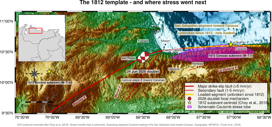
In other words, two centuries ago, this exact fault junction hosted a multifault sequence that began in the west where the 2026 doublet nucleated, and ended at the capital. The 2026 earthquakes reoccupied the western segment of the 1812 pattern. The question 1812 forces us to ask is: What about the eastern segment?
Which way did the stress go?
Typically, the direction in which a rupture grows matters as much as its size. On an east–west, right-lateral fault, a rupture that propagates and steps eastward — as the 2026 mainshock did, nucleating east of its foreshock — focuses its radiated energy, and therefore its strongest shaking, toward the east, toward Caracas. This is a feature of what’s called directivity. The static (Coulomb) stress passed to neighboring faults depends mainly on how slip was distributed across the rupture. Because the doublet stepped eastward, that load, too, was likely added to the segment in the capital’s direction (Figure 4), which maps the Coulomb static stress transfer produced by the M7.5 rupture.
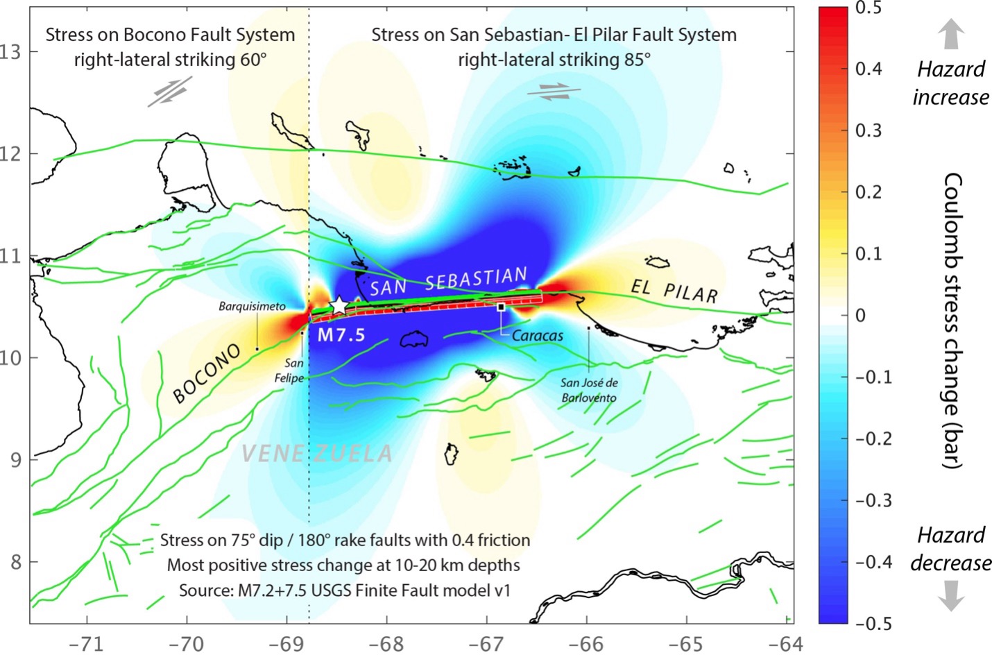
Which specific segment likely received this transfer of stress? East of Yumare, the next segment of the San Sebastián Fault runs beneath the Serranía del Litoral (the northern Coastal Range in Venezuela) toward the cities of La Guaira and Caracas: the onshore segment implicated in the 1812 Caracas subevent and unbroken in a great earthquake since.
The Coulomb model (Figure 4) sharpens the picture in both directions. To the east, the faults beneath Caracas, Guarenas, and San José de Barlovento are brought significantly closer to failure — by 0.1 bar or more, enough to drive aftershocks and, less likely, to hasten a future mainshock. To the west, the Boconó Fault is loaded toward failure as well, raising the possibility of a southwest-propagating rupture there and additional shaking for San Felipe and Barquisimeto.
The 2026 doublet did the one thing a hazard analyst least wants to see at a junction like this. It likely loaded the segment that points to the capital (Figure 3). Caracas is among the worst possible targets. Much of the metropolitan area rests on a deep, sediment-filled basin that amplifies and prolongs shaking — the mechanism behind the disproportionate destruction of the 1967 Caracas earthquake. In fact, regional velocity models have now resolved exactly these strong crustal contrasts along the coast (Moreno Toiran et al., 2022).
A coast already flagged
None of this is a surprise if one looks carefully at earthquake hazard models. Continental- and regional-scale assessments place damaging ground motion squarely along this coast (Petersen et al., 2018; Zimmerman et al., 2021). The Caribbean’s sovereign parametric insurance model is built on the same sources (Salgado-Gálvez et al., 2022).
Purpose-built ground-motion models for northern South America now exist to translate a rupture like this into expected shaking (Arteta et al., 2022). What the region has lacked is dense local monitoring. Work training neural networks on Venezuelan stations to detect and locate the seismicity around Carabobo (Tous et al., 2020) shows both the appetite for such monitoring and the gap. And tsunamis are also possible, generated by submarine slope failures caused by a strike-slip earthquake here rather than the earthquake itself (Soto et al., 2022).
What to watch
Three things will tell us whether the eastward-loading hypothesis is right. First, the aftershocks: A distribution that elongates and migrates east, toward Morón and the central coast, would confirm the rupture’s directivity.
Second, detailed studies of the San Sebastián Fault itself would help. This fault has never received the paleoseismic and GPS attention given to Boconó and El Pilar.
The 2026 doublet repeated the opening of 1812: It broke in the west, exactly where the older sequence began. It ruptured eastward, stopping short of pushing along the length of the El Pilar segment. Whether the rest follows is not something we can predict. But we now know which way the stress is leaning, and it leans toward the capital.
References
Arteta, C. A., Pajaro, C. A., Mercado, V., Montejo, J., Arcila, M., and Abrahamson, N. A., 2023, Ground-motion model (GMM) for crustal earthquakes in northern South America (NoSAm Crustal GMM), Bulletin of the Seismological Society of America, 113(1), 186–203, http://doi.org/10.1785/0120220168
Audemard, F. A., Singer, A., Soulas, J.-P., and the Neotectonics Section of FUNVISIS, 2006, Quaternary faults and stress regime of Venezuela, Revista de la Asociación Geológica Argentina, 61(4), 480–491.
Choy, J. E., Palme, C., Guada, C., Morandi, M., and Klarica, S., 2010, Macroseismic interpretation of the 1812 earthquakes in Venezuela using intensity uncertainties and a priori fault-strike information, Bulletin of the Seismological Society of America, 100(1), 241–255, http://doi.org/10.1785/0120080345
Dewey, J. W., 1972, Seismicity and tectonics of western Venezuela, Bulletin of the Seismological Society of America, 62(6), 1711–1751, http://doi.org/10.1785/BSSA0620061711
Ekström, G., Nettles, M., and Dziewoński, A. M., 2012, The global CMT project 2004–2010: Centroid-moment tensors for 13,017 earthquakes, Physics of the Earth and Planetary Interiors, 200–201, 1–9, http://doi.org/10.1016/j.pepi.2012.04.002
Moreno Toiran, B., Aoudia, A., Manu-Marfo, D., Kherchouche, and Pachhai, S., 2023, Crust–uppermost mantle structure beneath the Caribbean region from seismic ambient noise tomography, Bulletin of the Seismological Society of America, 113(1), 574–591, http://doi.org/10.1785/0120220062
Paige, S., 1930, The earthquake at Cumaná, Venezuela, January 17, 1929, Bulletin of the Seismological Society of America, 20(1), 1–10, http://doi.org/10.1785/BSSA0200010001
Pérez, O. J., 1998, Seismological report on the Mw 6.8 strong shock of 9 July 1997 in Cariaco, northeastern Venezuela, Bulletin of the Seismological Society of America, 88(3), 874–879, http://doi.org/10.1785/BSSA0880030874
Petersen, M. D., Harmsen, S. C., Jaiswal, K. S., Rukstales, K. S., Luco, N., Haller, K. M., Mueller, C. S., and Shumway, A. M., 2018, Seismic hazard, risk, and design for South America, Bulletin of the Seismological Society of America, 108(2), 781–800, http://doi.org/10.1785/0120170002
Salgado-Gálvez, M. A., Ordaz, M., Singh, S. K., Perez-Campos, X., Huerta, B., Bazzurro, P., and Faga, E.,, 2023, A Caribbean and Central America seismic hazard model for sovereign parametric insurance coverage, Bulletin of the Seismological Society of America, 113(1), 644–666, http://doi.org/10.1785/0120220117
Soto, S., von Hillebrandt-Andrade, C., Vanacore, E. A., Chacón-Barrantes, S., and Brome, A., 2023, CARIBE WAVE: a decade of exercises for validating tsunami preparedness in the Caribbean and adjacent regions, Bulletin of the Seismological Society of America, 113(1), 787–804, http://doi.org/10.1785/0120220095
Tous, R., Alvarado, L., Otero, B., Cruz, L., and Rojas, O., 2020, Deep neural networks for earthquake detection and source region estimation in north-central Venezuela, Bulletin of the Seismological Society of America, 110(6), 3162–3175, http://doi.org/10.1785/0120190172
Tozer, B., Sandwell, D. T., Smith, W. H. F., Olson, C., Beale, J. R., and Wessel, P., 2019, Global bathymetry and topography at 15 arc sec: SRTM15+, Earth and Space Science, 6(10), 1847–1864, http://doi.org/10.1029/2019EA000658
U.S. Geological Survey, 2026, M7.5 and M7.2 — Yumare, Venezuela earthquakes (us6000t7zp; us6000t7zc), https://earthquake.usgs.gov/earthquakes/eventpage/us6000t7zp
Zimmerman, M. T., Shen-Tu, B., Shabestari, K., and Mahdyiar, M., 2023, A comprehensive hazard assessment of the Caribbean region, Bulletin of the Seismological Society of America, 113(1), 667–696, http://doi.org/10.1785/0120210157
Copyright
Text © 2026 Temblor. CC BY-NC-ND 4.0
We publish our work — articles and maps made by Temblor — under a Creative Commons Attribution-NonCommercial-NoDerivatives 4.0 International (CC BY-NC-ND 4.0) license.
For more information, please see our Republishing Guidelines or reach out to news@temblor.net with any questions.
- Venezuela’s doublet leaned toward Caracas - June 30, 2026
- Is Southern California’s Cajon Pass an ‘earthquake gate’ ready to open? - June 29, 2026
- Philippines magnitude 7.8 shock may have loaded the central Cotabato subduction zone - June 11, 2026