By David Jacobson, M.Sc., Temblor
Click here to protect yourself from natural disasters

At the start of the month, in the Sea of Galilee, a small swam of earthquakes occurred, which resulted in minor shaking felt around Israel. While there was no major damage from the quakes, the largest of which was a M=4.7, according to the USGS, it did provide a wakeup call to a region that could experience moderate magnitude quakes, which could have a significant impact on the area.
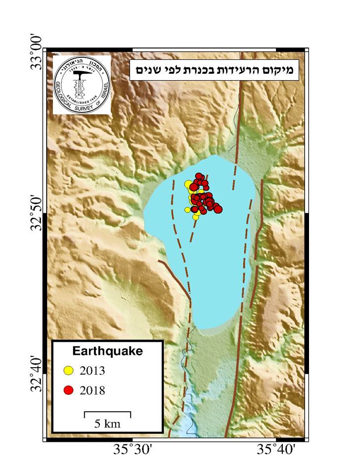
In total, at the start of the month, there were over 60 small to moderate magnitude earthquakes at the northern end of the Sea of Galilee. This part of Israel has seen similar swarms, including in 2013, as well as larger, more damaging quakes. In the figure above, courtesy of the Geological Survey of Israel, the location of the recent earthquakes, as well as a similar swarm in 2013, are shown. All of these events appear to have occurred on the Dead Sea Transform, a left-lateral strike-slip fault system extending from the Gulf of Aquaba in the south, to southern Turkey. This fault accommodates the motion between the Arabian and African plates, and has been responsible for historic, large, damaging earthquakes.
In addition to being the cause of both large and small earthquakes, the Dead Sea Transform also helped form both the Sea of Galilee, and the Dead Sea to the south. Both of these seas are known as pull-apart basins, and are the result of extension along the transform. As is common with most continental strike-slip faults, the Dead Sea Transform is segmented, which means earthquake ruptures tend to be limited by structural discontinuities.
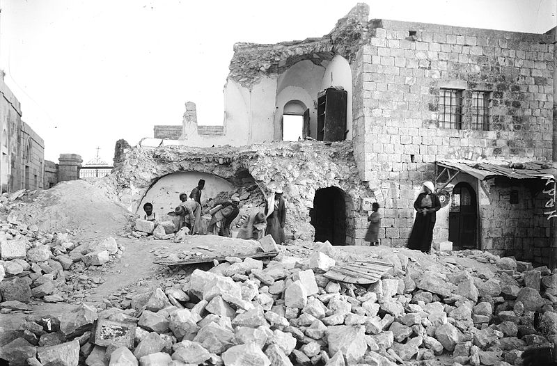
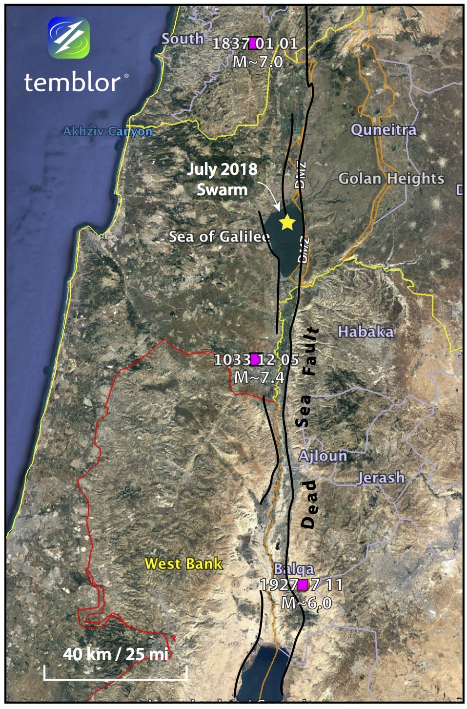
Despite this, M=6+ earthquakes are still possible, and have happened in the last century. In 1927, a M=6.0 earthquake struck just north of the Dead Sea and resulted in significant damage in numerous cities, including Jerusalem; around 300 people were killed. Going even farther back, two more earthquakes in the region, in 1837 and 1033 also likely struck along segments of the Dead Sea Transform, and are shown in the map below. Therefore, it is a fault that must be recognized as posing a significant threat to the region.
References
Geological Survey of Israel
USGS
N. N. Ambraseys, Comparison of frequency of occurrence of earthquakes with slip rates from long-term seismicity data: the cases of Gulf of Corinth, Sea of Marmara and Dead Sea Fault Zone, Geophys. J. Int. (2006) 165, 516–526, doi: 10.1111/j.1365-246X.2006.02858.x
Albini P., Musson R.M.W., Rovida A., Locati M., Gomez Capera A.A., and Viganò D. (2014). The Global Earthquake History. Earthquake Spectra, May 2014, Vol.30, No.2, pp. 607-624. http://doi.org/10.1193/122013EQS297
Albini P., Musson R.M.W., Gomez Capera A.A., Locati M., Rovida A., Stucchi M., and Viganò D. (2013). Global Historical Earthquake Archive and Catalogue (1000-1903). GEM Technical Report 2013-01 V1.0.0, 202 pp., GEM Foundation, Pavia, Italy.
ISC-GEM Earthquake Catalog
- Beware quiet segments of the Philippine Fault - May 16, 2025
-
ډیری عوامل افغاني ټولنې د زلزلې پر وړاندې زیانمنوي
- August 11, 2022 - What’s happening this week in Humboldt County, California: The squeeze - February 6, 2019