The magnitude-7.3 earthquake that struck off the coast of Mindanao, Philippines, this week could have inflicted heavy damage had the quake been shallow and onshore.
By Mario Aurelio, Director of the University of the Philippines National Institute of Geological Sciences, Mahar Lagmay, Executive Director, University of the Philippines Resilience Institute-Nationwide Operational Assessment of Hazards Center (@nababaha), John Agustin Escudero, Structural Geology and Tectonics Laboratory at the University of Philippines National Institute of Geological Sciences, Sandra Catugas, Structural Geology and Tectonics Laboratory at the University of Philippines National Institute of Geological Sciences
Citation: Aurelio, M., Lagmay, M., Escudero, J. A., and Catugas, S., 2021, Another large earthquake strikes the southern Philippines, Temblor, http://doi.org/10.32858/temblor.196
A magnitude-7.3 earthquake struck off the coast of Davao Oriental in Mindanao, southern Philippines, at 1:46 a.m. local time on Aug. 12 (17:46 UTC Aug. 11), according to the Philippine Institute of Volcanology and Seismology (PHIVOLCS). The epicenter was located about 170 kilometers southeast of Davao City, the third-largest Philippine metropolis. This seismic event released more than 30 times the amount of energy than the magnitude-6.6 earthquake that struck the northern island of Luzon July 24 (Aurelio et al., 2021). Had the focus of the Aug. 12 earthquake been shallow and occurred on land, it could have inflicted heavy damage to life and property. Thankfully, damage was minimal and no deaths were reported.
Complex collision, subduction and strike-slip tectonics
The Philippines features a very complex tectonic setting that involves six active subduction systems that surround the Philippine Mobile Belt (Aurelio, 2000). The west-dipping Philippine Trench is one of those subduction zones; the Davao earthquake was generated by the downing Philippine Sea Plate, presently subducting along trench.
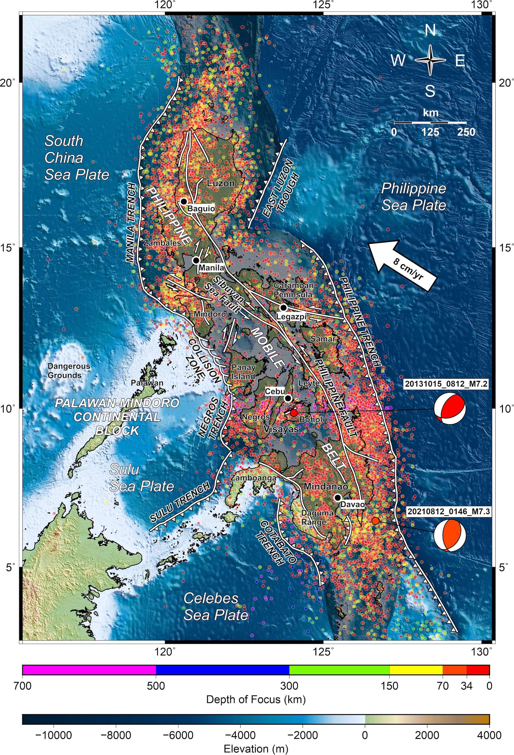
The other subduction zones consist of the four east-dipping systems that include the Manila Trench, Negros Trench, Sulu Trench and Cotabato Trench, and the west-dipping East Luzon Trough (Figure 1). These trenches, together with numerous active faults within the Philippine Mobile Belt, help accommodate the oblique convergence between the Philippine Sea Plate and the eastern margin of the Eurasian Plate at a rate that varies from about 3.6 centimeters per year in Taiwan to about 8.2 centimeters per year in the central and southern Philippines (e.g., Seno, 1977). Subduction along the Philippine Trench has been estimated to be about 3.0 centimeters per year (e.g., Rangin et al., 1999).
The southern Philippines alone hosts five subduction zones plus major active strike-slip faults (Aurelio, 2000). Three of the subduction zones are expressed as oceanic trenches. At the latitude where the earthquake took place, these trenches include from west to east, the Sulu Trench, Cotabato Trench and Philippine Trench (Figure 2).
The two other subduction zones involve a single oceanic plate, the Mollucas Sea Plate, that is being consumed from both the east and the west. On the west side, the subducted part of the plate reaches more than 600 kilometers into the mantle. The eastern side dives shallowly to a depth of about 200 kilometers. Though this asymmetrically folded plate has two subduction zones, the axis of this fold lies about 150 kilometers below the seafloor, resulting in no trenches. Instead, this peculiar geometry is inducing incipient collision between the Sangihe and Halmahera arcs of northern Indonesia (e.g., Roeder, 1977; Hall, 2002). GPS data indicate that these two arcs are approaching each other at a very fast rate of about 8.0 centimeters per year (Aurelio et al., 1998; Rangin et al., 1999).
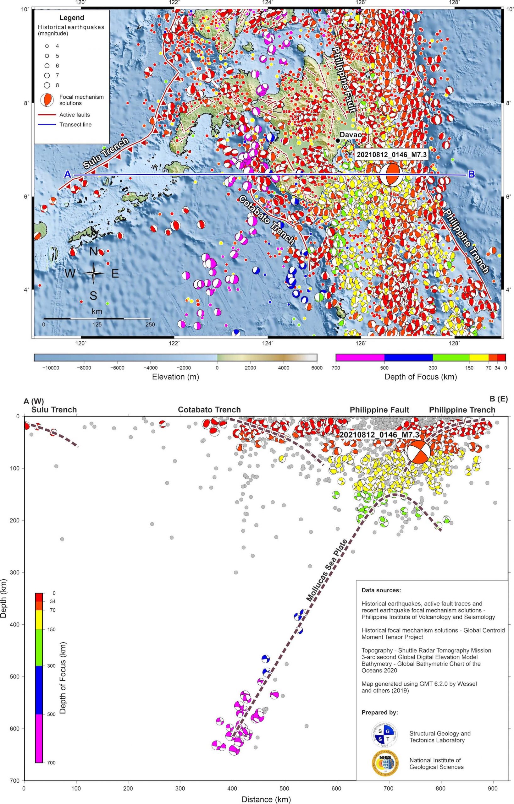
Between the Cotabato Trench and Philippine Trench are major active strike-slip faults, including the Philippine Fault, a known generator of destructive earthquakes such as the magnitude-7.8 Luzon Earthquake of July 16, 1990 (Sasaki and Okahara, 1991; Velasco et al., 1996), and the Cotabato Fault system, responsible for a destructive seismic sequence of four greater-than-magnitude-6 earthquakes in late 2019 occurring within a period of only two weeks (Aurelio, 2019; Zhao et al., 2021).
Despite the tectonic complexity of the region, the Davao earthquake appears to be clearly associated with the Philippine Trench subduction. Seismological observatories (i.e., PHIVOLCS, USGS-NEIC, GEOFON, GEOSCOPE) place the earthquake’s depth between 44 and 69 kilometers. The focal mechanism solution (the beachball diagram) indicates a moderately dipping thrust fault pair; that plus the rupture depth — shallower than 150 kilometers — are consistent with the geometry of subduction along the Philippine Trench at this latitude (Figure 2).
What can a magnitude-7.3 earthquake do?
Mindanaoans are fortunate because the earthquake was deep and it did not occur on land. Had the earthquake been shallower or onshore, infrastructure damage and death toll would have been high. The magnitude of this earthquake is as strong as the magnitude-7.2 earthquake that struck Bohol Island on Oct. 15, 2013 (Aurelio, 2013; Lagmay and Eco, 2014; Rimando et al., 2019 – see Figure 1 for location of epicenter), which killed more than 200 people, displaced hundreds of thousands of residents, and caused more than 2 billion pesos worth of infrastructure damage (NDRRMC, 2013). Aside from thousands of collapsed residential and commercial establishments, destruction involved damage to roads, bridges and ports mainly due to ground rupture, landslides, liquefaction and sinkhole collapse. Even the world-renowned natural wonder Chocolate Hills were not spared. Numerous, century-old UNESCO world-heritage churches suffered extensive damage, some completely pulverized (Figure 3).

Magnitude 7.2 is also the estimated magnitude that could be generated by movement of the West Valley Fault (MMEIRS, 2004; Nelson et al., 2000) that traverses the eastern sector of Metropolitan Manila, the capital city and center of government and economy of the Philippines. A study in 2004 projected that should a magnitude-7.2 earthquake strike Metro Manila, about 33,000 people would die and infrastructure would suffer a heavy toll (MMEIRS, 2004).
Citizen science, preparedness and earthquake education
The magnitude-7.3 Davao earthquake was also detected by privately owned low-cost seismometers not only from stations in the southern portion of the Philippines, but also from those installed in Malaysia, Australia, Solomon Islands and Marianas Islands (Figure 4). The records generated by citizen scientists were consistent with the results of the government-owned Philippine Seismic Network operated by PHIVOLCS in terms of magnitude and depth. These low cost-seismometers, developed by Raspberry Shake, have been tried and tested both in the laboratory (Anthony et al., 2019) and in the field (Manconi et al., 2018; Winter et al., 2021; Holmgren, 2021).

The growing number of individually owned seismometers in the Philippines is part of a global network of publicly available, low-cost but professional-grade seismometers deployed all over the world by enthusiasts and private groups. The recorded datasets that are streamed online by the citizen-maintained seismometers contribute to the densification of government-deployed instruments and complement efforts to detect seismicity all over the world, including those generated by landslides or volcanic activity.
The National Institute of Geological Sciences and the College of Science of the University of the Philippines have embarked on a program to magnify the efforts of citizen scientists, consistent with the Sendai Framework for Disaster Risk Reduction guiding principles of a whole-of-society and science-based approach to resilience. The program involves the promotion of earthquake education and research to deepen the understanding of Philippine tectonics and increase disaster awareness among the populace.
This earthquake, like the July 24 one and others before it, serves as a reminder that people and governments need to prepare against the constant threat of natural hazards.
References
Anthony, R.E., Ringler, A., Wilson D.C., and Wolin, E. (2019). Do Low-Cost Seismographs Perform Well Enough for Your Network? An Overview of Laboratory Tests and Field Observations of the OSOP Raspberry Shake 4D. Seismological Research Letters. 90 (1): 219-228.
Aurelio, M.A. (2000). Tectonics of the Philippines revisited. Journal of the Geological Society of the Philippines. 55, 3/4, 119-183.
Aurelio, M.A., (2013). Magnitude 7.2 Bohol quake: an unknown fault strikes again. https://opinion.inquirer.net/64133/magnitude-7-2-bohol-quake
Aurelio, M.A., (2019). What’s baffling about recent Mindanao earthquakes. https://newsinfo.inquirer.net/1187971/whats-baffling-about-recent-mindanao-quakes
Aurelio, M.A., Peña, R.E., and Taguibao, K.J.L. (2013). Sculpting the Philippine archipelago since the Cretaceous through rifting, oceanic spreading, subduction, obduction, collision and strike-slip faulting: Contribution to IGMA5000. Journal of Asian Earth Sciences, 7, 102-107 http://dx.doi.org/10.1016/j.jseaes.2012.10.007
Aurelio, M.A., Simons, W.F. Almeda, R.L. and the Philippine GPS Team. (1998). Present-day plate motions in the Philippines: Interpretation of GPS results of GEODYSSEA. In: The GEODYnamics of S and SE Asia (GEODYSSEA) Project. Eds. Wilson, P. and Michel, G. Scientific Technical Report STR98/14 Potsdam, Germany, December 1998. pp. 251-263.
Aurelio, M., Lagmay, M., Escudero, J. A., and Catugas, S. (2021). Latest Philippine earthquake reveals tectonic complexity, Temblor, doi.org/10.32858/temblor.191
GEOFON German Research Center for Geosciences. Available at: www.geofon.gfz-potsdam.de
GEOSCOPE Network – Reseau Gobal de Stations Sismologiques Large Bande. Available at: http://geoscope.ipgp.fr/index.php/fr/
Hall, R. (2002). Cenozoic geological and plate tectonic evolution of SE Asia and the SW Pacific: computer-based reconstructions, model and animations. J. Asian Earth Sci. 20 (4), 353–431.
Holmgren, J.M and Werner, M. (2021). Raspberry Shake Instruments Provide Initial Ground‐Motion Assessment of the Induced Seismicity at the United Downs Deep Geothermal Power Project in Cornwall, United Kingdom. The Seismic Record 1 (1): 27–34.
Lagmay, A.M.F. and Eco, R.N. (2014). Brief communication: On the source characteristics and impacts of the magnitude 7.2 Bohol earthquake, Philippines. Natural Hazards and Earth Systems Sciences 14 (10), 2795-2801.
Manconi, A., Coviello, V. and Galletti, M. (2018). Short Communication: Monitoring Rockfall with the Raspberry Shake. Earth Surface Dynamics 6(4): 1219-1227.
MMEIRS (2004). Earthquake Impact Reduction Study for Metropolitan Manila, Republic of the Philippines. A joint study by: Japan International Cooperation Agency (JICA), Metropolitan Manila Development Authority (MMDA), Philippine Institute of Volcanology and Seismology (PHIVOLCS). Final Report.
National Disaster Risk Reduction Management Council – NDRRMC (2013). SitRep No.35 re Effects of Magnitude 7.2 Sagbayan, Bohol Earthquake
Nelson, A. R., S. F. Personius, R. E. Rimando, R. S. Punongbayan, N. Tungol, H. Mirabueno, and A. Rasdas (2000). Multiple large earthquakes in the past 1500 years on a fault in metropolitan Manila, the Philippines, Bull. Seismol. Soc. Am. 90, no. 1, 73–85, doi: 10.1785/0119990002.
Philippine Institute of Volcanology and Seismology (PHIVOLCS). Available at: www.phivolcs.dost.gov.ph
Rangin, C., Le Pichon, X., Mazzotti, S., Pubellier, M., Chamot-Rooke, N., Aurelio, M., Walpersdorf, A. and Quebral, C. (1999). Plate convergences measured by GPS across the Sundaland/Philippine Sea Plate deformed boundary: the Philippines and eastern Indonesia. Geophysical Journal International, 139, 296-316.
Rimando, J.M., Aurelio, M.A., Dianala, J.D.B., Taguibao,K.J.L., Agustin,K.M.C., Berador, A.E.G., Vasquez, A.A. (2019). Coseismic ground rupture of the October 15, 2013 Magnitude (MW) 7.2 Bohol Earthquake, Bohol Island, Central Philippines. Tectonics, https://doi.org/10.1029/2019TC005503
Roeder, D. (1977). Philippine arc system – Collision or flipped subduction zones? Geology, 5, 203-206.
Sasaki, Y. and Okahara, M. (1991). Damage to civil engineering facilities from the July 1990 Philippine earthquake. NIST Special Publication, 820, 111-142.
Seno, T. (1977). The instantaneous rotation vector of the Philippine Sea Plate in relation to the Eurasian Plate. Tectonophysics, 42, 209-226.
United States Geological Survey – National Earthquake Information Center (USGS-NEIC). Available at: www.earthquake.usgs.gov
Velasco, A.A., Ammo, C.J., Lay, T. and Hagerty, M. (1996). Rupture process of the 1990 Luzon, Philippines (MW=7.7), earthquake. Jour. Geophys. Res. B: Solid Earth, 101(B10), 22419-22434.
Wessel, P. and Smith, W.H.F., (1995). New version of the Generic Mapping Tools released. EOS Trans. Am. Geophys. Union 76, 329.
Winter, K., Lombardi, D. Diaz-Moreno A., and Bainbridge, R. (2021). Monitoring Icequakes in East Antarctica with the Raspberry Shake. Seismological Research Letters. Doi: https://doi.org/10.1785/0220200483
Zhao, L., Qu, C., Shan, X., Zhao, D., Gong, W. and Li, Y. (2021). Coseismic deformation and multi-sli oseismic deformation and multi-fault slip model of the 2019 Mindanao earthquake sequence derived from Sentinel-1 and ALOS-2 data. Tectonophysics, 799, 228707 https://doi.org/10.1016/j.tecto.2020.228707
- Venezuela’s doublet leaned toward Caracas - June 30, 2026
- Is Southern California’s Cajon Pass an ‘earthquake gate’ ready to open? - June 29, 2026
- Philippines magnitude 7.8 shock may have loaded the central Cotabato subduction zone - June 11, 2026