Sand dikes formed during ancient earthquakes indicate that Virginia might have experienced an earthquake as large as magnitude 6.5 in the last few millennia.
By Laura Fattaruso, M.S., Ph.D. Candidate, UMass Amherst (@labtalk_laura)
Citation: Fattaruso, L., 2021, Virginia riverbanks tell the story of past large earthquakes, Temblor, http://doi.org/10.32858/temblor.195
People on the East Coast of the United States tend not to worry much about earthquakes. But in August 2011, a magnitude-5.8 earthquake struck near Mineral, Virginia, with shaking reported up and down the coast, from Maine to Georgia, and as far west as Chicago. The widely felt Mineral earthquake was a reminder that while damaging earthquakes may be infrequent, the East Coast is not immune to them.

Paleoseismologist Martitia Tuttle wanted to figure out just how often faults in this part of Virginia produce earthquakes. In a new paper published in Seismological Research Letters, she and colleagues presented geologic evidence of past earthquakes in the region. The team uncovered details on where earthquakes happen, how large they might be and how often they occur. The researchers hope their work on past events will lead to a better understanding of earthquakes on the East Coast — and better preparedness for future events.
Reconnaissance
After an earthquake, geologists head to the field and take measurements of the damage, noting things like ground ruptures or landslides. In the case of the Mineral earthquake, the fault that produced the temblor didn’t break the ground surface. Instead, all evidence of the earthquake in the area was left by the shaking.
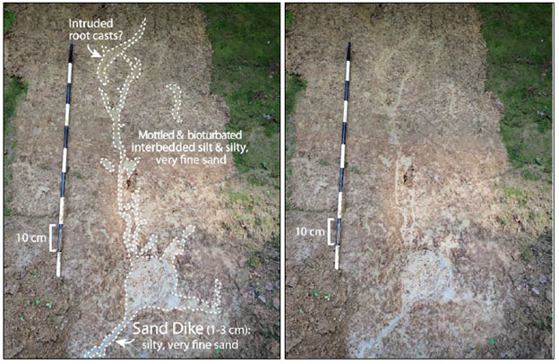
Right after the Mineral earthquake, geologists from Virginia Tech and the U.S. Geological Survey (USGS) found numerous sand blows in the area around the epicenter; sand blows, also called sand boils or sand volcanoes, are domes of sand that can appear on riverbeds and floodplains after earthquakes. The Virginia sand blows were produced by a process called liquefaction. When loosely packed sediments that are saturated with water experience shaking, they begin to behave like a liquid. You can see this phenomenon at the beach where sand meets ocean — jumping or shaking your foot can produce jiggling ripples in the sand. When this happens on a large scale, it can cause huge amounts of ground damage.
When a saturated, sandy layer has a stronger sediment layer on top of it, the pressure produced within that layer by liquefaction causes sand to burst through the layers above it. The resulting sand volcano forms a dome of sand on the surface, connected to the original layer by an injection vein, or pipe, called a sand dike. Sediment layers may also be disturbed and displaced without the sand dike reaching the surface.

A couple months after the Mineral earthquake, Tuttle went out to look at the sand blows that the initial reconnaissance team had documented, but they had been completely washed away by Hurricane Irene. While scouting out the South Anna River where the sand blows had last been seen, Tuttle noticed one young sand dike that probably formed during the Mineral earthquake and evidence of previous incidents of liquefaction in the banks of the river — a possible record of older earthquakes. While the domes of the sand blows had washed away, the injection veins that channeled the material to the surface remained.
Earthquake detectives
The time between earthquakes varies by location and can range from a few decades to centuries or millennia. Pinning down how often an earthquake might occur — the recurrence intervals — requires looking for evidence of past earthquakes, a field known as paleoseismology. In the Central Virginia Seismic Zone that hosted the Mineral earthquake, historical records documented moderate to large earthquakes in 1758, 1774 and 1875.
By dating the sediment layers that hosted the sand dikes, Tuttle could estimate the oldest possible age for each earthquake. She concluded that many of the geologic features were produced during these historical earthquakes. Some of the sand dikes, though, were formed during a larger earthquake — or perhaps a pair of magnitude-6 earthquakes — that happened some time between 350 and 2,800 years ago. Regardless of whether the sand dike features formed from two magnitude-6 quakes or one magnitude-6.5, it is clear that in the past, the region has experienced an earthquake bigger than the 2011 temblor, Tuttle and her colleagues noted.
“We’ve got a really hard problem here in the eastern part of the U.S.,” says John Ebel, a seismic hazard expert at Boston College, who was not involved with the study. “We have history of occasional large earthquakes, but the geology doesn’t really show us anything about what modern faults might be active.”
Narrowing down the exact location and timing of ancient earthquakes depends on what kind of geologic evidence is available to work with. When an earthquake ruptures the ground surface, that provides direct evidence of where the earthquake originated. In this case, all Tuttle and her colleagues had was evidence of shaking from preserved liquefaction features. Their team is still working to refine age estimates; Tuttle says she hopes that using more data techniques to date the sediment layers may better constrain the timing of these past earthquakes.
What next?
While the moderately sized Mineral earthquake was felt far and wide, there were no casualties and minimal injuries. An estimated $200 million to $300 million USD in damages occurred, including damage to the Pentagon, the Washington Monument, the Armed Forces Retirement Home, the National Cathedral, and hundreds of homes.
Ebel says the study deserves attention from people who are planning and developing parts of Virginia. “Those who live in cities near the Central Virginia Seismic Zone, Richmond for example — if you’re on the fence about including seismic hazard in the design and construction of new buildings, you’re better off including it,” he notes.
It can be a challenge to get people on the East Coast thinking about seismic hazard, Tuttle says. “If people haven’t experienced [an earthquake] themselves, they tend not to think about it,” she says. “Even when they learn about historical events like the 1886 Charleston earthquake, it’s still hard to get your mind around.”
References
Tuttle, M., et al. (2021) The Liquefaction Record of Past Earthquakes in the Central Virginia Seismic Zone, Eastern United States. https://doi.org/10.1785/0220200456.
- Venezuela’s doublet leaned toward Caracas - June 30, 2026
- Is Southern California’s Cajon Pass an ‘earthquake gate’ ready to open? - June 29, 2026
- Philippines magnitude 7.8 shock may have loaded the central Cotabato subduction zone - June 11, 2026