A new open-source wildfire model could help predict which wildfires will cause the most economic damage across the globe, informing preventative strategies.
By Erin Martin-Jones, Ph.D., University of Cambridge
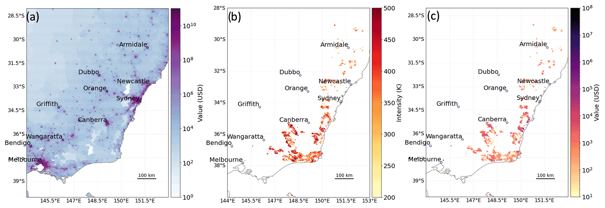
Citation: Martin-Jones, E., 2022, Scientists get closer to predicting economic losses from wildfires, Temblor http://doi.org/10.32858/temblor.259
Each year, wildfires cost insurers billions of dollars in losses – particularly in the U.S. Prolonged droughts, coupled with other weather extremes and changing land-use, are stoking wildfires, which are increasing in both severity and extent; fires are now spreading to previously unaffected areas. A key challenge for insurers and planners is assessing where wildfires will spark and which will be most costly.
Researchers are tackling this problem by developing a simulation of wildfire risk to populations and infrastructure on a global scale. The analysis, presented last month at the European Geosciences Union General Assembly, pinpoints areas of the world at risk of wildfires and where mitigation plans should be considered.
“Many insurance companies cover buildings across the world– it makes sense for them to have access to one globally consistent model that works anywhere, including in data-poor areas,” says study author Carmen Steinmann.

The soaring cost of wildfires
Every day a wildfire happens somewhere across the world. They are part of a natural process of forest regeneration: cycling nutrients back into the soil and helping plants to set seed.
The climate crisis is changing wildfire risk. Wildfire claims have run to tens of billions of dollars in recent years, with 70% of claims in the last five years alone, according to Swiss Re. Prolonged droughts mean more dry vegetation, which fuels longer, more intense wildfire seasons — even in previously unaffected areas (Sullivan et al., 2022).
A global picture of wildfire risk
Forecasts of economic loss already exist for hazards including earthquakes, tropical cyclones and floods, but predicting wildfire damage is still in its infancy and is often restricted to areas where wildfires are a common occurrence.
The new wildfire model combines satellite data on historic wildfires with population statistics and land use information to generate simulations of probable wildfire seasons. By modeling the occurrence and spread of wildfires under a range of scenarios, researchers aim to improve estimates of risk to people and properties.
They can identify a wildfire that costs $1 billion (USD) against one that costs $100 million (USD) through simulating thousands of wildfire seasons — a level of precision in line with models for other natural hazards such as tropical cyclones.
Previously, global wildfire occurrence predictions were only available as outputs from large climate models, used to calculate burning over large areas and its contribution to global greenhouse gas emissions. The resolution of these simulations, which average wildfires over roughly 60 miles (100 kilometers), meant there was insufficient data to examine impacts to buildings.
“High-resolution wildfire models are needed for more accurate estimates of wildfire risk, which subsequently enables an improved ability to assess relevant adaptation measures,” says Marleen de Ruiter, Assistant Professor at the Institute for Environmental Studies at Vrije Universiteit Amsterdam, who was not involved with the study.
The model is the latest in a series of developments in the CLIMADA (CLIMatic ADAptation) package — a toolkit developed by the Weather and Climate Risk Group at ETH Zurich, and used by bodies including the World Bank to assess risks from a range of natural hazards across the globe.

From modeling to adaptation
The researchers now plan to work with modelers to understand how wildfire characteristics will change under climate change scenarios. “Selecting the handful of wildfires that are damaging out of thousands of simulations is really complex, especially as our changing climate will affect wildfires in ways we don’t yet fully understand,” explains Samuel Lüthi, a graduate student also working on the project.
De Ruiter, who works on multi-hazard risk analysis, adds that risk assessments get challenging when natural hazards overlap with each other — an increasingly common scenario as our climate changes. “Wildfire risk is almost never a stand-alone event and often coincides with drought or heatwave conditions.”
CLIMADA already allows for multi-hazard analysis, and the researchers hope to build wildfires into this aspect of the model in the future.
The team’s work goes beyond modeling. “CLIMADA was really initiated because we wanted to kick-start the conversations needed for adaptation,” says Lüthi. “We might be making this tool here in Zurich — but we’re talking about risk across the globe: people’s lives and livelihoods. Pinpointing risk hotspots is really important but it’s just the beginning; we need local collaboration and knowledge.”
References
Steinmann, C.B., Lüthi, S., Gübeli, S., Guillod, B.P. and Bresch, D.N., 2022. Downscaling global wildfire model output to a relevant scale for probabilistic wildfire risk assessment of economic impacts (No. EGU22-8854). Copernicus Meetings.
Sullivan, A., Baker, E. and Kurvits, T., 2022. Spreading Like Wildfire: The Rising Threat of Extraordinary Landscape Fires.
Further Reading
Lüthi, S., Aznar-Siguan, G., Fairless, C. and Bresch, D.N., 2021. Globally consistent assessment of economic impacts of wildfires in CLIMADA v2. 2. Geoscientific Model Development, 14(11), pp.7175-7187.
Ward, P.J., Blauhut, V., Bloemendaal, N., Daniell, J.E., de Ruiter, M.C., Duncan, M.J., Emberson, R., Jenkins, S.F., Kirschbaum, D., Kunz, M. and Mohr, S., 2020. Natural hazard risk assessments at the global scale. Natural Hazards and Earth System Sciences, 20(4), pp.1069-1096
- Venezuela’s doublet leaned toward Caracas - June 30, 2026
- Is Southern California’s Cajon Pass an ‘earthquake gate’ ready to open? - June 29, 2026
- Philippines magnitude 7.8 shock may have loaded the central Cotabato subduction zone - June 11, 2026