By Tiegan E. Hobbs, MSc., and Ph.D. candidate, Georgia Institute of Technology

A great quake among giants
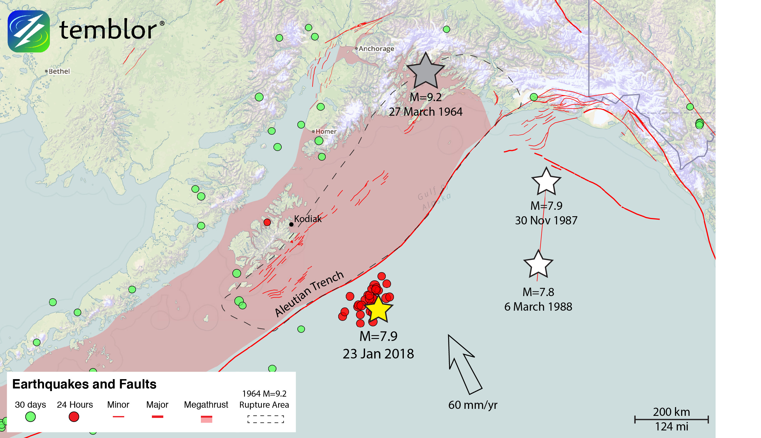
An earthquake occurred in the Gulf of Alaska at 12:31 am local time this morning (9:31:42 UTC). The event was located 360 miles (580 km) south of Anchorage, off the south coast of the remote Kodiak Island archipelago. This region is no stranger to earth shaking. The same spot that ruptured today sits just 60 miles (95 km) seaward of the Aleutian Trench, the subduction zone responsible for the second-largest earthquake ever recorded (M=9.2 Prince William Sound, or ‘Good Friday,’ Earthquake of 1964, ref. 1). As of 4:14 am Alaska time, the magnitude of this event is listed by the USGS as Mw=7.9 (2). For reference, that’s the same size as the historic San Francisco Earthquake of 1906 which ruptured 296 miles (477 km) of the San Andreas Fault and effectively leveled the city (3). Luckily, this event occurred far from any major cities, such that no loss of life or property damage is expected (4).

Tsunami Advisory
Even though this earthquake was a strike-slip event (meaning the plates slide past one another horizontally), a tsunami was generated. Commonly, tsunamis are only launched by earthquakes with large vertical seafloor motions, so that they displace more water. Coastal Alaska remains in tsunami advisory for a 500 mile (800 km) stretch of the coastline centered around the epicenter. Unlike a tsunami watch, which is an automatically-generated alert that there is potential for a tsunami, a tsunami advisory indicates that a tsunami has been observed. In this case, water level has been measured at 0.4-0.7 ft (0.15 m) above regular tide height in nearby cities of Kodiak, Seward, Old Harbor, Yakutat, and Sitka (5).
No remote global aftershocks were triggered
The 2012 M=8.6 strike-slip earthquake, which struck oceanward of the Sumatra trench, triggered an explosion of worldwide M≥5.5 aftershocks in the next several days, and these events began within hours of the mainshock. Because strike-slip earthquakes generate very strong ‘Love waves’ that encircle the globe in about 80 minutes, and can nudge other strike-slip faults toward failure, we looked for this phenomenon in today’s Alaska quake. We found five M≥4.5 events in the 9 hours before the Alaska mainshock, whereas there has only been one (north of New Zealand) afterwards. So, if anything, the globe has been quieter after the mainshock than beforehand, and no global triggering is (yet) evident.
An unexpected strike-slip event in the ‘outer rise’
This type of earthquake is known as an outer rise event. A subduction zone creates a trench where the two plates meet at the seafloor, and the outer rise is the oceanic side of that trench where the plate is gently warped upward before it plunges under the Alaskan mainland. These environments commonly host extensional (called ‘normal’) earthquakes, which result from tension in the upwarped plate, and more rarely, strike slip events like the event this morning. In the past, there have been outer rise earthquakes that trigger or are triggered by events on the nearby megathrust. An example is the 2009 Samoa-Tonga earthquake sequence (6), in which an extensional outer rise event triggered two damaging megathrust events, or the 2011 Mw=9.0 Tohoku, Japan earthquake, which triggered hundreds of large aftershocks in the outer rise (7). Understanding outer rise earthquakes, and how they converse with the megathrust, is essential to forecast megathrust and tsunami hazards.
Ocean bottom seismometers to the rescue
In addition to the need to understand the evolving seismic hazard in the area, evaluating the effect of today’s earthquake on the adjacent megathrust is of particular interest to the scientific community. Plans have been underway for months to deploy 75 ocean bottom seismometers to the very region that ruptured this morning (8). The goal of this project is to collect as much data as possible about the Alaskan megathrust. The team will add seafloor seismic data to that which is already being collected by the Transportable Array, a network of 280 land-based seismic stations deployed to Alaska starting in 2014 (8). Researchers will use this information to probe what controls fault behavior on an active megathrust.
Alaska is the perfect place to do this, given that an earthquake is recorded by the Alaskan Earthquake Information Center roughly every 15 minutes (9). Studying very active subduction zones is a good way to gain insights into less active, but potentially more dangerous plate boundaries like the Cascadia megathrust off the coast of Oregon, Washington, and British Columbia.

References
1) https://earthquake.usgs.gov/earthquakes/events/alaska1964/
2) http://earthquake.usgs.gov/earthquakes/eventpage/us2000cmy3#moment-tensor
3) http://earthquake.usgs.gov/earthquakes/events/1906calif/18april/
4) http://earthquake.usgs.gov/earthquakes/eventpage/us2000cmy3#shakemap?source=ak&code=ak18173527http://tsunami.gov/events/PAAQ/2018/01/23/p3054t/5/WEAK51/WEAK51.txt
5) Lay, T., Ammon, C. J., Kanamori, H., Rivera, L., Koper, K. D., & Hutko, A. R. (2010). The 2009 Samoa-Tonga great earthquake triggered doublet. Nature, 466(7309), 964-968.
6) Lay, T., Ammon, C. J., Kanamori, H., Kim, M. J., & Xue, L. (2011). Outer trench-slope faulting and the 2011 Mw 9.0 off the Pacific coast of Tohoku Earthquake. Earth, planets and space, 63(7), 37.
7) http://geoprisms.org/wpdemo/wp-content/uploads/2016/03/AACSE-DeployPlanForWeb_Sep2017.pdf
8) http://www.usarray.org/alaska
9) http://earthquake.alaska.edu/earthquakes/about
10) https://earthquake.usgs.gov/earthquakes/eventpage/us2000cmy3#executive
- Beware quiet segments of the Philippine Fault - May 16, 2025
-
ډیری عوامل افغاني ټولنې د زلزلې پر وړاندې زیانمنوي
- August 11, 2022 - What’s happening this week in Humboldt County, California: The squeeze - February 6, 2019