By David Jacobson, Temblor

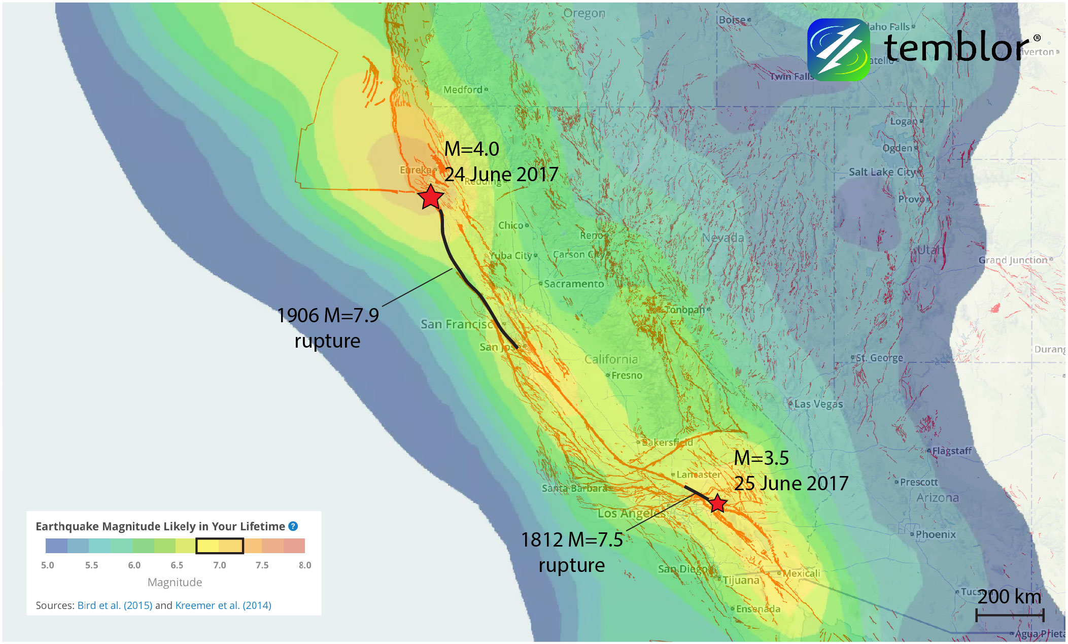
Over the weekend, there were earthquakes on either end of the San Andreas Fault system, highlighting the tips of two great earthquakes. In Northern California, a M=4.0 quake near the Mendocino Triple Junction marks the terminus of the 1906 M=7.9 earthquake which devastated San Francisco. In Southern California, a M=3.5 earthquake just east of San Bernardino is the southern end of the 1812 M=7.5 Wrightwood earthquake that killed 40 people in a church in San Juan Capistrano over 100 km away. While neither of the quakes over the weekend were large enough to cause damage, there were both felt, and because of the importance of their locations, deserve attention.
In Northern California, the Mendocino Triple Junction marks the meeting point between the Pacific, North American, and Gorda tectonic plates. Because these three tectonic plates are all moving at different rates and speeds, significant strain builds up, resulting in one of the most seismically active places on earth. Additionally, because the plates are moving in different directions, there is oblique collision resulting in both strike-slip and compressional earthquakes. The M=4.0 earthquake had both components of right-lateral and thrust movement.

The Mendocino Triple Junction is also important because it marks the northern terminus of the San Andreas Fault, and the southernmost extent of the Cascadia Subduction Zone, which extends for 1,000 km to Vancouver Island in Canada. Furthermore, this region was stressed in both the 1906 earthquake, and again in a M=6.9 earthquake in 1992 that caused significant damage and injured hundreds of people. So, even though the area is sparsely populated it is an area prone to large and damaging quakes.

In Southern California, yesterday’s M=3.5 earthquake occurred in between the main strand of the San Andreas, and the Banning Fault. While the San Andreas is purely strike-slip, the Banning Fault is compressional, meaning that like the Mendocino Triple Junction, this part of Southern California is also undergoing oblique collision, which is why we have the San Bernardino Mountains. This area is also important because it not only marks the southern terminus of the 1812 M=7.5 earthquake, but the start of a southward bend in the San Andreas, where there are numerous fault splays.
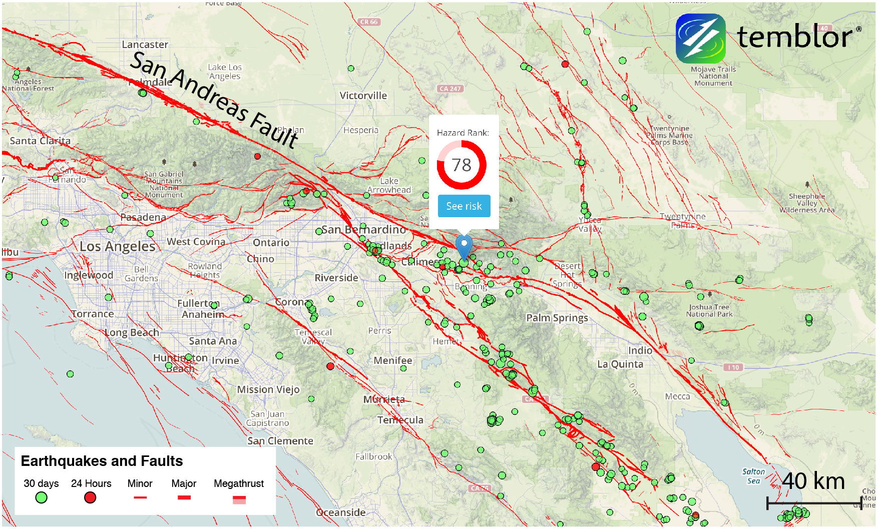
Because of the stress built up in these locations in both Northern and South California, each area is susceptible to experiencing a large earthquake. Based on the Global Earthquake Activity Rate (GEAR) model, which is available in Temblor, we can see that the Mendocino Triple Junction is prone to experiencing a M=7+ earthquake in your lifetime, while the region in Southern California is likely to see a M=6.75+. Therefore, it is important to highlight these areas, because of the seismic hazard they pose to the State of California.
References
USGS
John C. Rollins and Ross S. Stein, Coulomb stress interactions among M ≥ 5.9 earthquakes in the Gorda deformation zone and on the Mendocino Fault Zone, Cascadia subduction zone, and northern San Andreas Fault, JOURNAL OF GEOPHYSICAL RESEARCH, VOL. 115, B12306, doi:10.1029/2009JB007117, 2010
Julian C. Lozos, A case for historic joint rupture of the San Andreas and San Jacinto faults, Sci. Adv. 2016, DOI: 10.1126/sciadv.1500621
- Earthquake science illuminates landslide behavior - June 13, 2025
- Destruction and Transformation: Lessons learned from the 2015 Gorkha, Nepal, earthquake - April 25, 2025
- Knock, knock, knocking on your door – the Julian earthquake in southern California issues reminder to be prepared - April 24, 2025