By David Jacobson, Temblor
Click here to protect yourself from natural disasters
An earthquake strikes the Bay Area
At 4:18 p.m. today, a M=7.0 earthquake will tear across the East Bay. The quake’s epicenter will be just east of downtown Oakland along the Hayward Fault. Shaking will be felt across the entire Bay Area, and in many areas, it will be strong enough to destroy buildings, and render many vital lifelines useless. Up to 400,000 people will be unable to use their homes, 22,000 people will be trapped in elevators, more than 400 gas and electric fires will start, and East Bay residents could lose tap water for up to 6 months. In total, losses will likely exceed $100 billion, and aftershocks will shake the region for years. Fortunately, this earthquake is not real, but rather a USGS scenario, dubbed HayWired, that will be presented to the public today, coinciding with the release of the scenario’s second volume, on the impacts of a large magnitude earthquake on the Bay Area.
At some point, a major earthquake will strike the Bay Area. While it is unknown when it will happen, the major players, the San Andreas, Hayward, and Calaveras faults are known. Even though today marks the 112th anniversary of the devastating San Francisco earthquake on the San Andreas Fault, the Hayward Fault rimming the East Bay also has devastating potential. Additionally, according to the USGS models, it is the Hayward Fault, that has the greatest likelihood (1 chance in 3) of rupturing in a M=6.7+ earthquake by 2043.

The goal of improving resiliency
Building on an effort to reduce earthquake risk in the Bay Area, “HayWired is the latest and best effort not to predict when an earthquake will happen, but to anticipate more clearly than ever before what the impacts would be” USGS Science Advisor for Risk Reduction and HayWired leader Ken Hudnut Ph.D., said. Last year, the first volume of HayWired, which focused on the earthquake hazard and scenario shaking footprint, was quietly released. Now many of the quake’s impacts, which will likely surprise Bay Area residents, have been brought to the forefront.
In producing this scenario, the coalition that put together HayWired aimed to not only highlight and address vulnerabilities of East Bay cities, but show that collectively, we can reduce our risk. Even though more than $50 billion has already been put towards seismic resilience, additional risk reduction is still needed Hudnut added. Therefore, by giving the scenario a platform, with the public as its audience, the scientists hope to make this earthquake relatable, and show people that they can outsmart disasters.
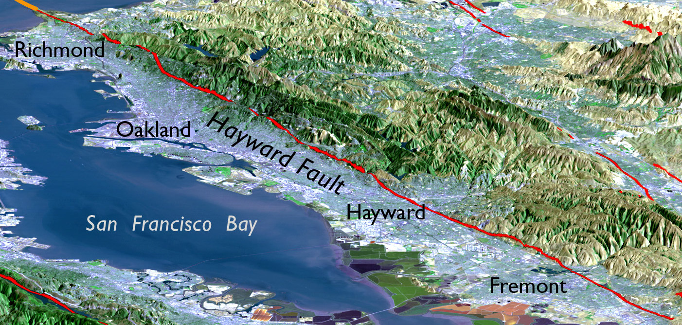
The Hayward Fault
While the San Andreas may get the majority of the publicity when it comes to Bay Area faults, the Hayward threatens more than 7 million people, and 2 million buildings. A major earthquake along it would not only impact the regional economy, but that of the entire country. Furthermore, infrastructure, such as roads, telecommunication lines, and pipes that cross the fault will likely be destroyed in a major earthquake.

Studies on the Hayward Fault have shown that large magnitude quakes tend to occur approximately every 110-220 years, and it has been almost 150 years since its last major rupture. In that M=6.8 earthquake in 1868, the city of Hayward was destroyed and five people were killed. The main reason why damage was “limited” was because the area was sparsely populated. This HayWired scenario attempts to convey what would happen if a similar event were to happen today.
What hazards can we expect?
When the Hayward Fault ruptures at 4:18 p.m. today, its epicenter will be just to the east of downtown Oakland. Traveling at speeds as great as 11,000 kph (7,000 mph), in less than a minute, it will rupture more than 83 km (52 mi) of its length. This includes area both north towards San Pablo Bay, and South towards San Jose. The video below, created by the USGS, shows an animation of shaking in this quake. This animation highlights how the entire Bay Area will be exposed to at least light-moderate levels of shaking, with extreme shaking experienced directly on the fault.
The animation below, from USGS Geophysicist Brad Aagaard, shows what shaking would be like around the Bay Area in the event of a M=7.0 Hayward Fault earthquake
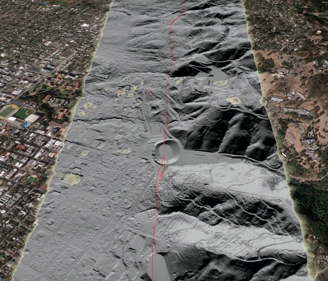
While shaking alone will be responsible for much of the damage sustained, additional hazards fault rupture, liquefaction, landslides, and aftershocks will also wreak havoc on the region. Fault rupture, could exceed 2 m (7 ft), which will damage, if not destroy, any structures or vital lifelines, including transportation infrastructure and utilities, that span the fault. This includes buried utilities such as water pipelines. Hudnut said that following the HayWired earthquake, some East Bay residents could be left without water for months. While this may seem extreme, similar conditions were seen following the 2011 M=6.3 Christchurch, New Zealand earthquake, which the HayWired researchers heavily studied to examine what might happen in a Hayward Fault earthquake.
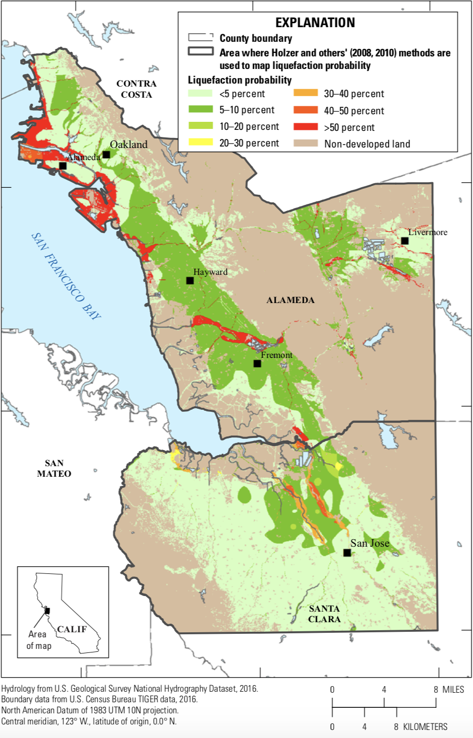
One of the more devastating impacts in Christchurch that will also likely affect the Bay Area is liquefaction, a process whereby saturated soil turns to quicksand during strong ground shaking. When this happens, the ground loses cohesion, which can cause buildings, cars and other heavy objects to sink or tilt. The photo below shows the impact of liquefaction experienced during the 1906 San Francisco earthquake.

Fortunately, the entire Bay Area will not liquefy. However, areas close to the Bay, including large parts of Oakland and Alameda, as well as Oakland International Airport, sit on highly liquefiable soil. The map below highlights regions most susceptible, which tend to be areas made of artificial fill. Unfortunately, even though the likelihood of liquefaction exceeds 75% in some areas, liquefaction is a hazard that is both hard to predict and expensive to mitigate. The best solution is to not build in those areas. However, because we cannot undo decades of construction, identifying the most at risk areas is vital to building more resilient communities as it can help us prevent putting important infrastructure in high risk zones.
Two final hazards posed to the Bay Area in a Hayward Fault earthquake are landslides and aftershocks. Because of the steep slopes in the East Bay, some areas have greater than a 32% chance of seeing a landslide. Even in the event of minor movement, infrastructure could be destroyed. Lastly, all of these hazards have the potential to be repeated in the event of large aftershocks. Following the HayWired earthquake, there is a 20% chance of a M=6.4+ earthquake. Such an event could trigger additional liquefaction or landslides, and aftershocks will shake the region for years.
How bad will it be and how can we protect ourselves?
Once the shaking from the HayWired earthquake stops, we will be forced to assess the impacts and help those in need. Highlighted in this second HayWired volume are some of those impacts, including damage to buildings and other infrastructure. Unfortunately, given the severity of the earthquake, the effects will likely be catastrophic. Some of the more striking numbers to take from this scenario include:
• 800 fatalities
• 18,000 injuries
• 2,500 people requiring rescue from buildings
• 22,000 people trapped in 4,500 stalled elevators
• 77,000-152,000 households displaced (Up to 411,000 people)
• East Bay residents lose water for 6 weeks to 6 months
• More than 400 gas and electric fires could ignite
• $82 billion in property and direct business losses
• An additional $30 billion in losses is possible due to fires
While these numbers may scare people, a key message that comes out of HayWired is that they are not set in stone. USGS scientist Ken Hudnut emphasized that, “this is not insurmountable. We can keep investing in preparation and mitigation, and so change what will happen.” For example, collapse-risk buildings can be retrofitted or torn down. Additionally, more resilient water pipelines can be installed, which would not only provide vital drinking water to Bay Area residents following an earthquake, but make fighting fires easier.

Even though improving resiliency in the face of an impending disaster seems prudent, there are often steep costs that can prevent action. A prime example of this is building codes in San Francisco, highlighted yesterday in an article in the New York Times. For years, high-rise buildings in the city were not a focus of seismic safety. A 50-story building only needs the same strength requirements as a five-story building and every building must have a 90% chance of avoiding total collapse in the event of the largest credible earthquake. Turn this the other way and that means there is a 10% chance of collapse, or 1 in 10 tall buildings could collapse. Additionally, the code does not require that a building be fit for occupancy after an earthquake. In a city with 160 buildings taller than 240 feet, this means extremely expensive measures will have to be taken to protect occupants and infrastructure.
Given these issues San Francisco will face, the entire Bay Area should see this as a reminder that putting off safety always has negative consequences. But, thanks to studies like HayWired, we can get a greater picture of what could happen, which can help us work towards outsmarting disasters.
References
USGS
Detweiler, S.T., and Wein, A.M., eds., 2017, The HayWired earthquake scenario—Earthquake hazards (ver. 1.1, March 2018): U.S. Geological Survey Scientific Investigations Report 2017–5013–A–H, 126 p., https://doi.org/10.3133/sir20175013v1. Link
Detweiler, S.T., and Wein, A.M., eds., 2018, The HayWired earthquake scenario—Engineering implications: U.S. Geological Survey Scientific Investigations Report 2017–5013–I–Q, 429 p., https://doi.org/10.3133/sir20175013v2. Link
New York Times
- Earthquake science illuminates landslide behavior - June 13, 2025
- Destruction and Transformation: Lessons learned from the 2015 Gorkha, Nepal, earthquake - April 25, 2025
- Knock, knock, knocking on your door – the Julian earthquake in southern California issues reminder to be prepared - April 24, 2025