Tonga’s underwater eruption hints at need for more seismic stations near such active, submarine volcanoes located near populated parts of the Pacific.
By Lise Retailleau, Ph.D., Observatoire Volcanologique du Piton de la Fournaise, Institut de Physique du Globe de Paris (@RetailleauLise)
Citation: Retailleau, L., 2022, Underwater volcanoes are difficult to monitor. Tonga eruption shows why, Temblor, http://doi.org/10.32858/temblor.243
One of the largest explosive volcanic eruptions in recent decades occurred on January 15, 2022, at Hunga Tonga–Hunga Haʻapai volcano in the Pacific Ocean, in the Kingdom of Tonga. It generated worldwide interest and concern because of the profusion of ash that exploded into the atmosphere, and the accompanying shock wave, tsunamis and isolation of the people of Tonga as their communications systems were cut and ash hampered rescue and first aid efforts. In the aftermath, scientists must consider what happened, what can be learned and how the island kingdom can prepare for future eruptions.

Two islands become one…
Hunga Tonga–Hunga Haʻapai is a mostly submarine volcano in the South Pacific Ocean located about 65 kilometers (40 miles) north of Tongatapu, Tonga’s main island. Tonga’s islands form part of the Tonga-Kermadec arc, which sits above a subduction zone where the Pacific plate rapidly plunges under the Indo-Australian plate at a rate of around 20 centimeters (0.8 inches) per year. This subduction generates numerous earthquakes, with each year bringing more than ten magnitude-6 and a few magnitude-7 events. A magnitude-8 earthquake typically strikes every few years, according to the U.S. Geological Survey earthquake browser.
The subduction of the Pacific plate beneath the Indo-Australian plate also results in the hundreds of volcanic islands and tens of submarine volcanoes that trace a line along the subduction zone, atop the Indo-Australian plate. Several of these volcanoes belong to the Kingdom of Tonga. Multiple oceanographic cruises have set sail to better understand the volcanic activity in the area, such as a cruise in 2009 that explored the submarine West Mata volcanic eruption, near Samoa.

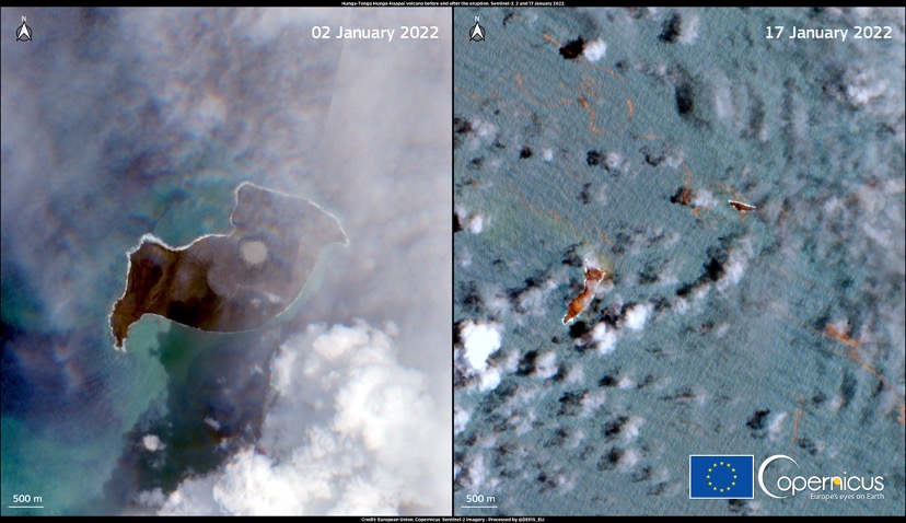
Hunga Tonga–Hunga Haʻapai’s formidable base at the bottom of the ocean is more than 20 kilometers (12 miles) in diameter. The volcano sees regular eruptions, notably in 2009 and between November 2014 and January 2015. In both cases, eruptions occurred on the sides of the main caldera — the central crater formed by a prior eruption that caused the volcano’s mouth to collapse. Prior to 2015, two preexisting islands, Hunga Tonga and Hunga Ha’apai, poked above sea level, with the submarine summit caldera about five kilometers (three miles) in diameter sitting between the two. The two islets were joined into a single island during the 2015 eruption, becoming Hunga Tonga-Hunga Ha’apai.
The volcano produces large explosions in which quickly erupting, gas-rich magma interacts with cold water, causing it to be torn into pieces of molten rock. The volcano’s 2009 and 2014-2015 eruptions both behaved this way, explosively emitting ash and volcanic fragments.
…and then became two again
On December 20, 2021, the volcano awoke, followed by another strong explosion on January 13, 2022. In both cases, eruptions produced ash and gas plumes with heights of between 15 and 20 kilometers (between nine and 12 miles). The eruption that began shortly after 5 pm local time on January 15, 2022, shot a plume of ash more than 35 kilometers (22 miles) into the air, sending a shock wave around the world — several times. Its sound was heard clearly in Fiji and New Zealand. Alaskans 9,000 kilometers (5,600 miles) away heard the boom, which rivaled that produced by the Krakatoa eruption of 1883.
The ash plume generated by the eruption covered the surrounding islands, depositing a few centimeters of ash on Tongatapu. The island’s residents were cut off from international and domestic communication when undersea telecommunication cables were severed. Repairs were not finished until late February. First aid flights could land no sooner than five days after the eruption.

The eruption generated many different types of waves, aside from the shock wave. Ground motion sensors picked up seismic waves produced by both the shock wave and the explosion of the volcano. The shock waves, which induce pressure changes in the atmosphere, were also recorded by barometers. Acoustic signals linked to the explosion propagated through the ocean and were recorded by hydrophones — underwater devices that record the sounds of the oceans. Infrasound waves — low frequency sound waves that humans cannot hear — were also recorded around the Pacific. Of course, the eruption also created a tsunami, which traveled not only around the Pacific ocean, but also to oceans around the world. Instruments around the world also detected a meteotsunami caused by the interaction between the shock wave and the ocean.

Satellite imagery collected after the eruption showed that the single island had been obliterated by the explosion. In its place, the volcano’s shorn edges peered above the surface of the ocean — two newly contoured islands instead of one.
Seismic spying
No clear seismicity preceded the eruption that could have forecasted the explosion. Even during the December 2021 and January 13, 2022, eruptions, no obvious precursor seismicity had been recorded. This could be due to the lack of seismic stations near the volcano. Often, precursor seismic activity prior to an eruption can be subtle and only detectable by a nearby network of seismic monitoring stations.
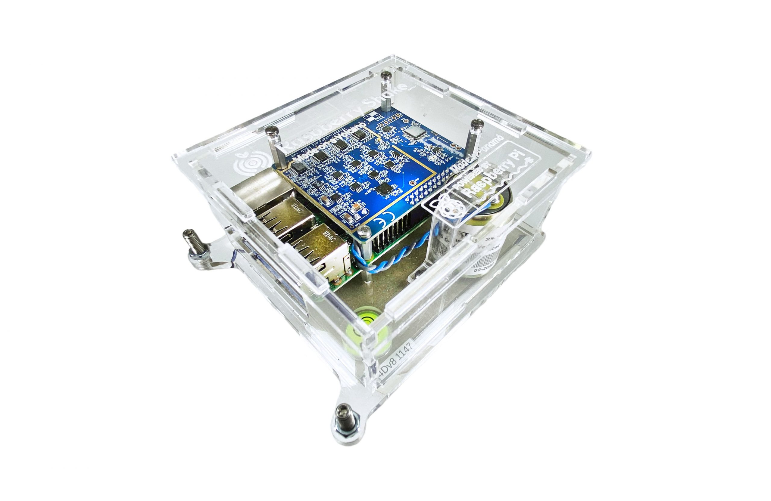
The Pacific Ocean is huge, and the islands are quite isolated, with many lacking seismic instrumentation. The closest station to Hunga Tonga–Hunga Haʻapai with available data is a Raspberry Shake — a citizen-science station — more than 700 kilometers (430 miles) away.
Although the majority of volcanism on Earth occurs underwater, submarine volcanoes are particularly hard to instrument because of a lack of access. For this reason, only a few are continuously monitored and have been studied extensively. Developments in satellite imagery now permit observations of volcanos in near-real time, as well as an analysis of the effects of an eruption once one begins, even in remote locations. For example, during the Fukutoku-Okanoba eruption South of Japan in August 2021, no clear seismic precursor had been detected. In that case, the nearest station was about 250 kilometers (155 miles) away, and the eruption was observed through satellite imagery.
Monitoring underwater volcanoes
In the Indian Ocean, a flurry of seismicity started in May of 2018 off the coast of Mayotte, a French-administered island near Mozambique. The numerous earthquakes were followed by the start of a large submarine eruption 50 kilometers (31 miles) from the coast, which gave rise to a volcano. Strong effort was made by the French community and government to develop a land network of seismic stations. Several oceanographic cruises set out to monitor the event and understand the behavior and history of this volcanic system. Although the main volcanic activity was located 3,000 meters (1.8 miles) below sea level, and appeared non-explosive, the area shows signs of previous explosive eruptions.

In particular, the “fer à cheval” area shows signs of a previous large eruption and is less than ten kilometers (six miles) away from the island, under about 1,500 meters (5,000 feet) of water. A strong eruption from this location could reach the surface and generate a tsunami that would likely impact the island of Mayotte, at a minimum. Studies are being carried out to estimate potential tsunami wave heights.
Should a new eruption closer to the coast of Mayotte begin, the relatively new seismic network should detect the waves. Recent developments in automatic detection and alerting should help to rapidly alert the population. However, though seismicity started a few weeks prior to the current eruption, sometimes the time between the start of seismicity and an eruption is much shorter, limiting inhabitants’ evacuation possibilities.
Eruption prediction is a tricky subject, even with well-instrumented volcanoes like Mayotte. Their sizes are unpredictable. This is especially true for submarine volcanoes, which constitute the majority of volcanism on Earth. Such volcanoes aren’t usually swathed in seismic stations, but Tonga’s eruption — like Mayotte’s — highlights how such information could be useful for forecasting future cataclysms. Deployments of low-cost sensor could help improve coverage with minimal expense.
In Tonga, though no seismicity was observed before Hunga Tonga–Hunga Haʻapai’s eruption on Jan. 15, seismicity ranging between magnitude 4 and 5 has since been recorded and located near the volcano, according to the USGS. This suggests that magma transfer linked to the eruptions that started in December of 2021 had little influence on the surrounding faults, and thus did not generate any earthquakes. The ultimate explosion on January 15, 2022, modified the area, generating an episode of seismicity that went on for weeks. Hopefully, this shaking won’t lead to a new eruption.
References
Retailleau, L., Saurel, J. M., Zhu, W., Satriano, C., Beroza, G. C., Issartel, S., … & OVSM Team. (2022). A Wrapper to Use a Machine-Learning-Based Algorithm or Earthquake Monitoring. Seismological Research Letters. https://doi.org/10.1785/0220210279
Further Reading
Duncombe, J. (2022), The surprising reach of Tonga’s giant atmospheric waves, Eos, 103, https://doi.org/10.1029/2022EO220050. Published on 21 January 2022.
- Venezuela’s doublet leaned toward Caracas - June 30, 2026
- Is Southern California’s Cajon Pass an ‘earthquake gate’ ready to open? - June 29, 2026
- Philippines magnitude 7.8 shock may have loaded the central Cotabato subduction zone - June 11, 2026