By Chris Rollins, Ph.D., Michigan State University, and Ross S. Stein, Ph.D., Temblor, Inc.
Two deadly and damaging quakes late last month were probably unrelated to each other.
Citation: Rollins, C., Stein, R.S., (2019), Two damaging tremors highlight the Philippines’ coast-to-coast earthquake problem, Temblor, http://doi.org/10.32858/temblor.021
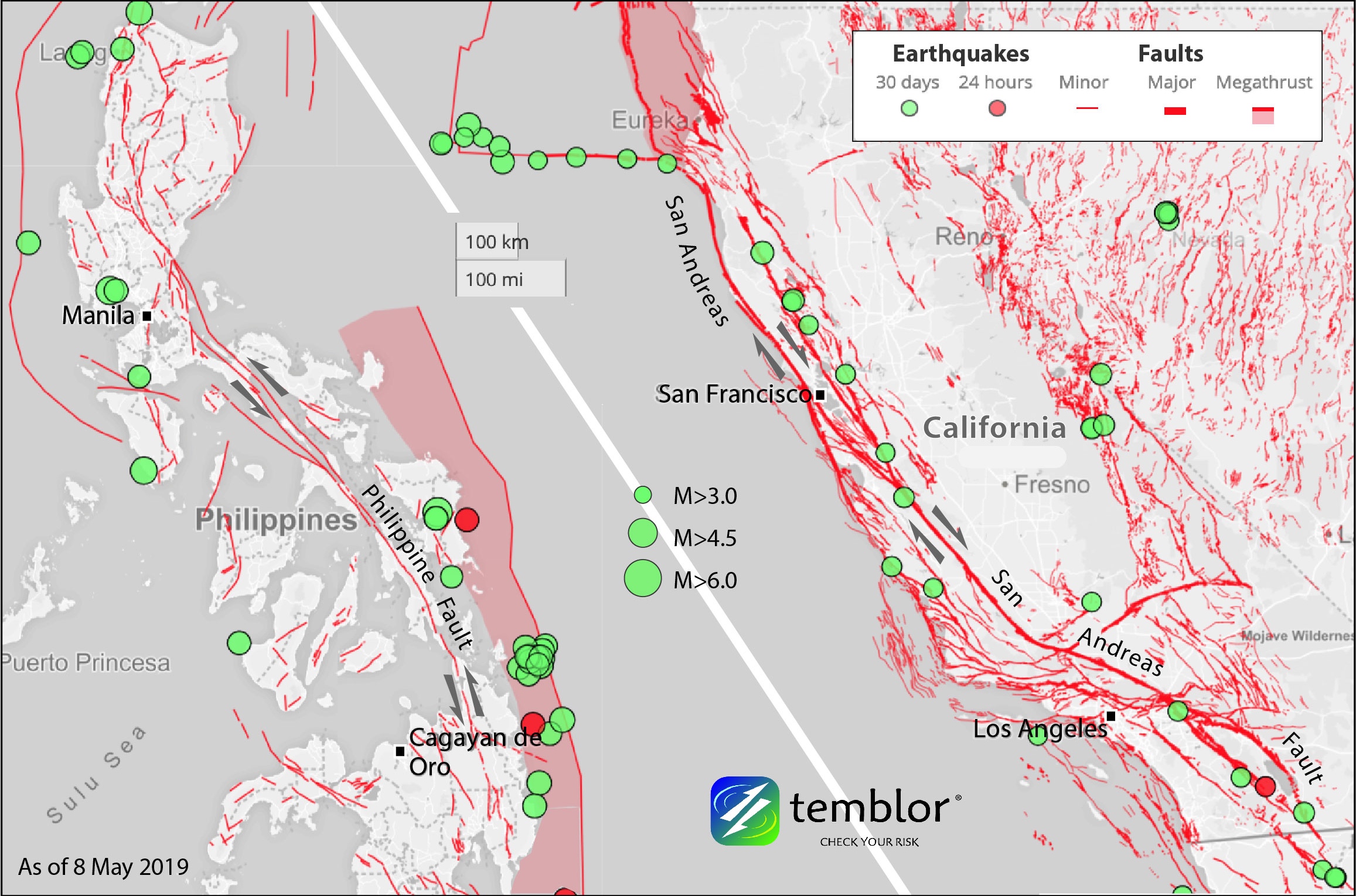
Unlike California, 100% of the Philippines is earthquake country. Two damaging and deadly earthquakes late last month served as a reminder of this.

The first quake was a near-miss of Manilla
On April 22 just after 5 PM local time, a magnitude 6.1 earthquake struck less than 85 km (50 mi) from the Philippine capital of Manila, in the provinces of Zambales and Pampanga on the northern island of Luzon. In footage that went viral around the world (link), the shaking ejected water out of a rooftop swimming pool atop a Manila skyscraper. But back on Earth, the earthquake killed 18 people and caused widespread damage in the epicentral region. Although the epicenter was in Zambales, shaking intensities and damage were worse in neighboring Pampanga, much of which sits on soft sediments that amplify shaking, as reported by the Philippine Institute of Volcanology and Seismology (PHIVOLCS). This is a recurring theme in earthquake hazard: we typically settle near water, often on unconsolidated sediments recently deposited by water flow. This is a good call except when an earthquake strikes.
Luzon is no stranger to earthquakes, as it is surrounded on the west and east by subduction trenches and sliced down the middle by the Philippine Fault, a major left-lateral strike-slip fault (whichever side you are on, the other side has moved to the left), with about the same character and slip rate as the San Andreas Fault. The fault likely partners with the subduction zones to accommodate different components of the regional tectonic strain in a “slip partitioning” system.
A tragedy and a success story that followed
In 1990, the Philippine Fault ruptured in a M=7.7 strike-slip earthquake that killed over 1,600 people on Luzon. That earthquake – which provides a possible parallel for future earthquakes on the San Andreas and other strike-slip faults around the world – also appears to have squeezed the magma chamber feeding nearby Mt. Pinatubo and hastened its catastrophic 1991 eruption, the second largest of the 20th century. The volcano reawakened immediately after the M=7.7 shock, and then steadily increased in seismicity and steam eruptions until PHIVOLCS and the USGS jointly announced a likely eruption and called for imminent evacuations. Twelve hours later, Pinatubo erupted, with the warning having saved thousands of lives. This was one of science, collaboration, and diplomacy’s finest hours. It is an ideal we continue to strive for today.

For its part, the earthquake on April 22 appears to have struck on a strike-slip fault parallel to, but well to the west of, the Philippine Fault. It did strike only 15 km (10 mi) from Pinatubo, so it could conceivably have been influenced by magmatic activity there. The reverse is unlikely, however: PHIVOLCS reported no sign of increased activity at Pinatubo after April 22.
The mysterious Philippine Trench
That’s more than enough tectonic unrest for one country (particularly one undergoing rapid development in the early 21st century), but it’s only one piece of the story in the Philippines. On the east side of the country lies the Philippine Trench, along which the Philippine Sea Plate is subducting westward beneath the archipelago. The Philippine Sea Plate’s motion is notoriously difficult to constrain because it is a fully “oceanic plate” with few islands on which to place GPS receivers to track its motion. Further, all of its boundaries are subduction zones, a rarity. But the convergence rate along the Philippine Trench probably exceeds 10 cm/yr (4 in/yr), faster than those in Japan and Alaska, and about three times faster than the Cascadia subduction zone in the Pacific Northwest. This means that the earthquake loading process is very rapid, and so great quakes should be frequent.
The Philippine Trench has produced a handful of M>7 earthquakes in the 20th century, and on April 23, it ruptured in a M=6.4 thrust earthquake beneath the island of Samar. This followed on the heels of the April 22 quake in Luzon by less than 24 hours, and although 48 people were injured, fortunately no one was killed. The April 23 quake occurred at around 45 kilometers (25 miles) depth, which may have resulted in milder shaking than had it struck closer to the surface. (This may also have been true in the 2018 M=7.1 Anchorage, Alaska earthquake, which was a different kind but also occurred at 45 km depth and resulted in no deaths).
Was the second quake triggered by the first?
With two M>6 earthquakes striking in less than 24 hours, were they connected in some way? There are two ways this could work: 1) static stress transfer, via the bending of the Earth in the April 22 event, or 2) dynamic triggering, where the waves from the April 22 M=6.1 event bump the April 23 fault towards failure. We can rule out static stress transfer: the two earthquakes occurred 575 km apart (350 miles, the distance from LA to San Francisco), well outside the range of significant stress change from a M=6.1 earthquake. Dynamic triggering is more elusive: the waves from the April 22 event were not felt more than 100 km (60 miles) away, one-sixth of the interevent distance; but the 1992 M=7.3 Landers, California earthquake and the 2002 M=7.9 Denali Fault earthquake did trigger seismicity at much greater distances.
A ‘smoking gun’ for this case would be if there was an uptick in seismicity or creep on the April 23 fault immediately after the waves from the April 22 event passed. This is difficult to pin down both because the April 23 event was rather deep and because it struck beneath the rugged and sparsely populated center of Samar, where the growing PHIVOLCS seismic network is understandably still sparse. Remember, though, that the April 23 event occurred in a stress regime featuring a subducting plate coming in faster than those in Japan and Alaska. That could generate an earthquake anytime, especially a M=6.4, and history shows that it does.
The pair is reminiscent of the much larger recent pair in Mexico: The 2017 M=8.2 Tehuantepec shock was followed 12 days later and 600 km away by the M=7.2 Puebla shock, which felled 38 buildings in Mexico City. In previous work, we found that it is unlikely that the two were causally related. The time difference in the Philippines case is much shorter, but quake rates there are much higher, and so the probability of a link seems similarly low. PHIVOLCS came to the same conclusion, and in a timely manner, immediately after the second quake.

More to come
These two earthquakes served as a reminder that the tectonic strain and the seismic hazard in the Philippines come from all sides, and fast. The Cotabato Trench to the south produced the Philippines’ deadliest earthquake in 1976, and the Manila Trench to the northwest poses a tsunami hazard to southeast Asia, coastal China and Hong Kong. The country is at risk.
References
Bautista, B.C., Bautista, L.P., Barcelona, E.S., Punongbayan, R.S., Laguerta, E.P., Rasdas, A.R., Ambubuyong, G., Amin, E.Q., and Stein, R.S. (1996), Relationship of regional and local structures to Mount Pinatubo activity, in R. S. Punongbayan and C. G. Newhall (Eds.), The 1991-1992 eruption of mount Pinatubo, Philippines, 351-370.
Hill, D.P., et al. (1993), Seismicity Remotely Triggered by the Magnitude 7.3 Landers, California Earthquake, Science 260(5114), https://science.sciencemag.org/content/260/5114/1617.
Prejean, S.G., Hill, D.P., Brodsky, E.E., Hough, S.E., Johnston, M.J.S., Malone, S.D., Oppenheimer, D.H., Pitt, A.M., and Richards-Dinger, K. B. (2004), Remotely Triggered Seismicity on the United States West Coast Following the Mw7.9 Denali Fault Earthquake, Bull. Seis. Soc. Am., 94(6B), https://doi.org/10.1785/0120040610.
Smoczyk, G., Hayes, G., Hamburger, M., Benz, H., Villasenor, A., and Furlong, K. (2010), Seismicity of the Earth 1900-2012: Philippine Sea Plate and Vicinity, USGS Open-File Report 2010-1083, https://doi.org/10.3133/ofr20101083M.
Wong, I., Dawson, T., and Dober, M. (2014), Evaluating the Seismic Hazards in Metro Manila, Philippines, 14th World Conference on Earthquake Engineering (14WCEE).
Ye, L., Lay, T., and Kanamori, H. (2012), Intraplate and interplate faulting interactions during the August 31, 2012, Philippine Trench earthquake (Mw 7.6) sequence, Geophys. Res. Lett., 39, L24310, doi:10.1029/2012GL054164.
Ph.D., California Institute of Technology, 2017