On July 8, 2021, a magnitude-6.0 earthquake in the Central Walker Lane fault zone shook California and Nevada. Walker Lane presents some conundrums.
By Ian Pierce, Ph.D., currently at University of Oxford, UK (@neotectonic)
Citation: Pierce, I., 2021, Tectonic mystery swirls as earthquake rocks California-Nevada border, Temblor, http://doi.org/10.32858/temblor.187
On the afternoon of July 8, 2021, a magnitude-6.0 earthquake rocked much of central California and western Nevada. Intense shaking that lasted as long as 20 seconds was reported 80 miles (~130 kilometers) away in Reno, while the Bay Area, Central Valley, Southern California and even Las Vegas all shook as well. Reports of damages are slowly trickling in from many of the remote communities nearest the shaking and videos of car-sized boulders on a major highway have gone viral. Since the mainshock less than 24 hours ago (at the time of posting), more than 100 aftershocks above magnitude 2.5 have rocked the region. More than 25,600 people have reported feeling shaking to the U.S. Geological Survey’s (USGS) Did You Feel It? website. If you felt the mainshock or any of the aftershocks — or if you didn’t — report them.
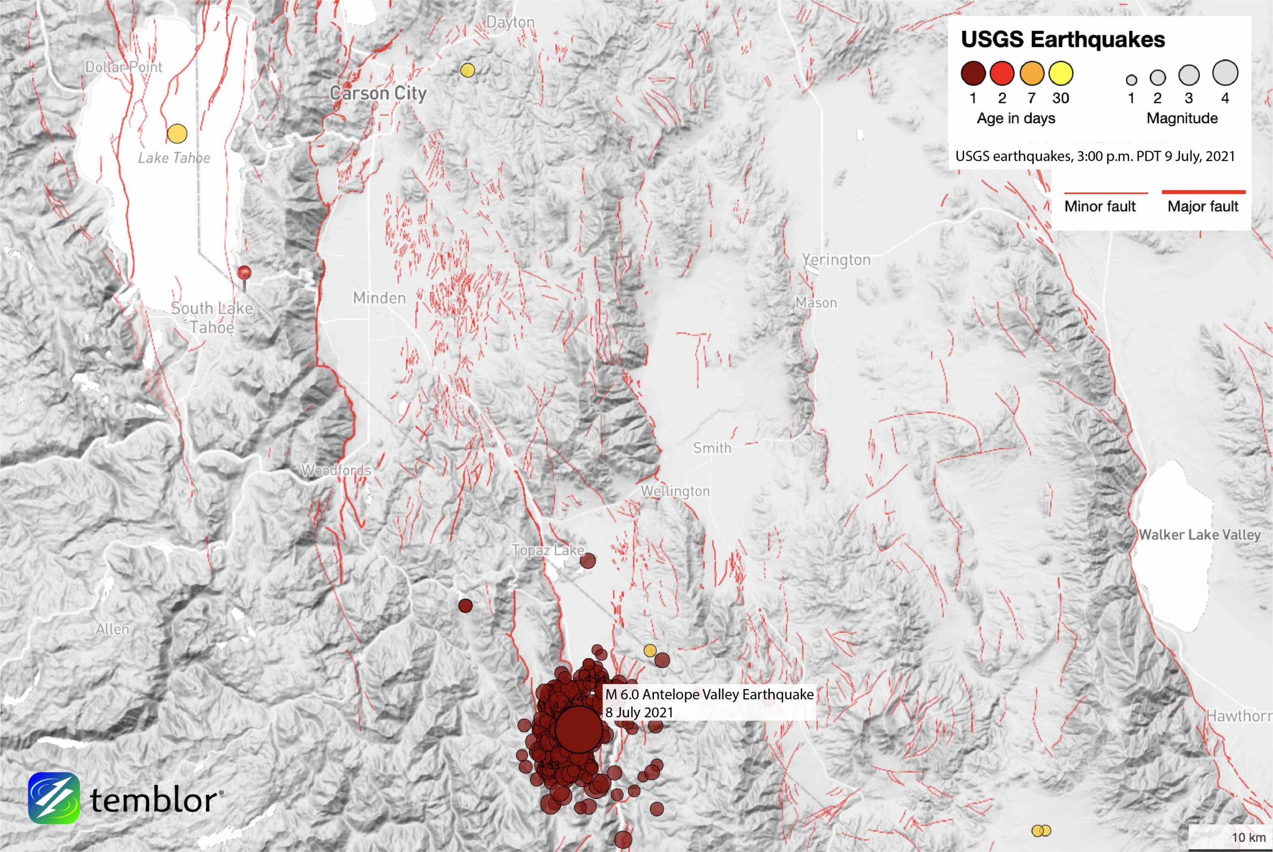
This earthquake originated in the seismically busy Central Walker Lane, between Yosemite National Park in California and Carson City, Nev., in the southernmost part of Antelope Valley. In the last three years, four large earthquakes — greater than magnitude 6.0 — have struck the Walker Lane region. What’s driving all this seismic activity and what does it mean for the earthquake hazards far from the famed San Andreas Fault?
Busy Walker Lane
The Walker Lane is a diffuse zone of normal and strike-slip faults. It follows an approximately 60-mile (100-kilometer)-wide swath along the Eastern Sierras and California/Nevada border, reaching from Death Valley and the Garlock Fault in the south to north of the Honey Lake Valley region. The Walker Lane Fault system accommodates roughly 20 percent of the 2-inch (50-millimeter) per year right-lateral shear between the Pacific and North American Plates, while the remaining 80 percent is accommodated along the more well-known San Andreas Fault system.

The Walker Lane has been getting much attention recently, and for good reason. In the last three years, far more moderate earthquakes have occurred along the Walker Lane Fault system than any other single fault system in the western United States. This earthquake is the fourth event larger than magnitude-6.0 since the 2019 Ridgecrest Earthquake Sequence that included magnitude-6.4 and magnitude-7.1 earthquakes, and the 2020 magnitude-6.5 Monte Cristo Range earthquake. In 2021 alone, yesterday’s earthquake joins a series of several other widely felt events ranging from magnitude 4 to 5 near Lake Tahoe and the Northern Sierras.
Yet, the Walker Lane didn’t start popping off events in 2019. In 2016 the Nine Mile Ranch sequence produced three events of about magnitude-5.5 near Hawthorne, Nev., in less than an hour, following a similar sequence from 2011. In 2008, the Mogul sequence rocked Reno, Nev., with a magnitude-4.7 quake. The largest-known Walker Lane event was the 1872 magnitude-7.4 Owens Valley earthquake, which is roughly the maximum magnitude we expect of an earthquake along any single fault in this system.
Decades of paleoseismic and tectonic studies have revealed dozens of faults throughout the Walker Lane, some with evidence of large prehistoric earthquakes that likely exceeded magnitude-7.0. For example, the most recent earthquake along the Genoa Fault near Carson City occurred about 450 years ago (Ramelli et al., 1999). The fault running beneath the west shore of Lake Tahoe most recently ruptured about 5,500 years ago (Pierce et al., 2017).
A tectonic mystery
Shifting attention to the tectonics of the Central Walker Lane where this most recent magnitude-6.0 event occurred, an unresolved tectonic mystery swirls. Using high accuracy stationary GPS stations, we can observe — in real time — the crest of the Sierra Nevada sliding northwest at a rate of about 0.3 inches (7 millimeters) per year relative to Fallon, Nev., shearing the region spanning Antelope, Smith, and Mason Valleys. Yet, geologically speaking, we cannot find sufficient strike-slip faulting to account for this observed shear.
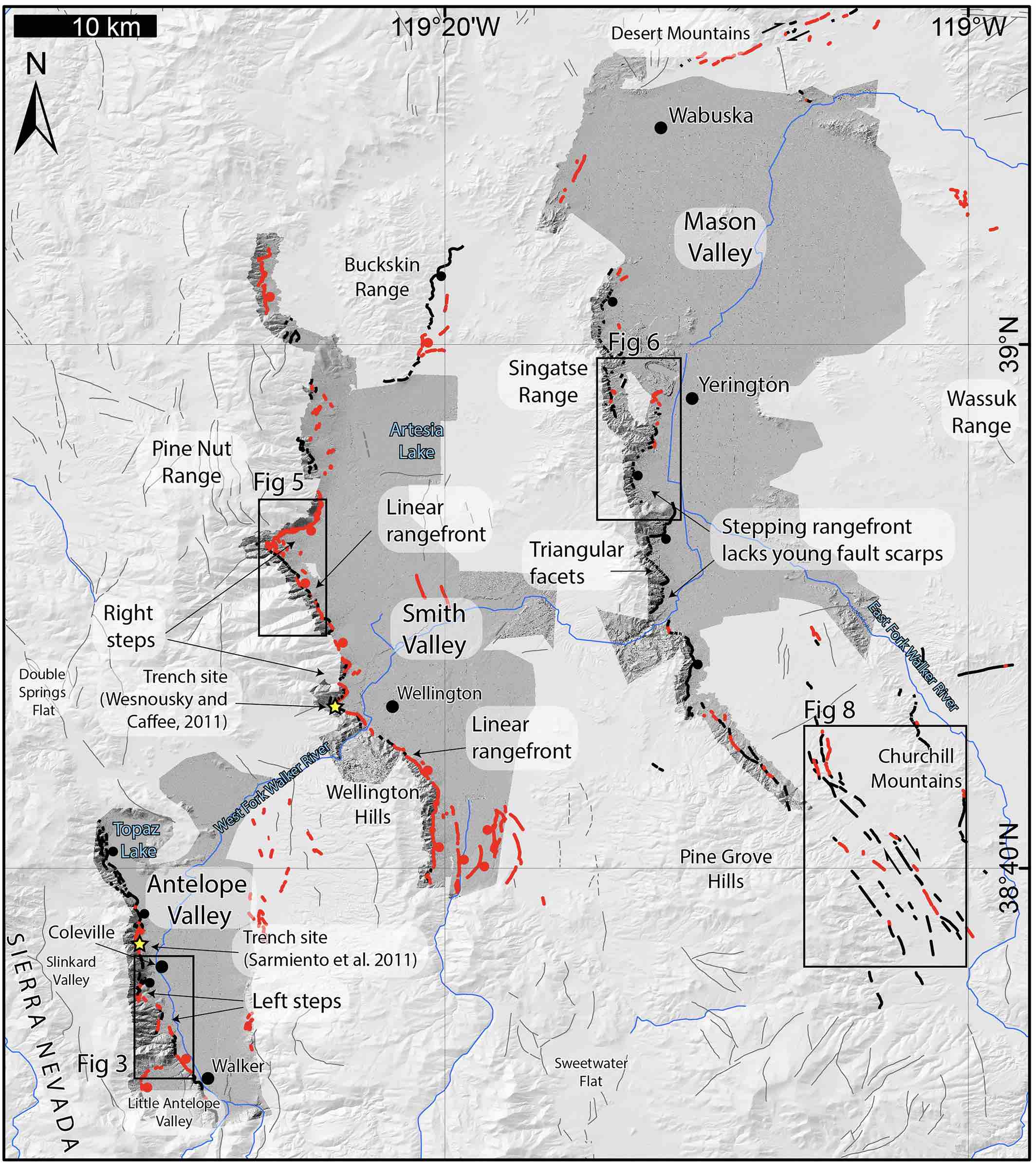
While a number of hypotheses have been proposed to explain this mismatch, we expect that future large earthquakes will show complex, transient and discontinuous deformation, as opposed to long-lasting fault strands that produce the fault scarps, large offsets of features in the landscape, and other geomorphologic features we would require to measure long-term faulting rates (Pierce et al., 2020). This more subtle, less dramatic style of deformation was witnessed in the 2020 Monte Cristo Range earthquake, as well as other earlier Walker Lane events. Other explanations for the missing measurable shear that we expect based on GPS data include clockwise rotations of basins and bounding normal faults, and obliquely slipping faults that bound the rangefronts of the mountains in this area.
The fault responsible for the July 8 magnitude-6.0 event produced a north-striking normal moment tensor — the beachball diagram seismologists use to determine both the orientation of a fault, and which way it moved. Normal faulting is consistent with the local patterns of faulting in Antelope Valley. In other words, the quake occurred on a north-striking fault that moves because of east-west directed extension, similar to what we would expect for the north-oriented Antelope Valley Fault that bounds the range. This fault does not have a significant oblique component, as one might expect if this range were accommodating right-lateral shear — the motion recorded by the San Andreas Fault, and the overall movement of the Walker Lane as recorded by GPS. This supports the conclusion of our 2020 paper suggesting this range does not exhibit oblique faulting — it is mostly normal.

Underappreciated hazards
All told, eastern California and western Nevada have much underappreciated earthquake hazards. While these hazards are well known to the earthquake science community, the public seems to view these moderate magnitude-5 to 6 events as “the big ones” when in reality, were the inevitable magnitude-7 event to occur in one of the rapidly developing communities of the region, the losses to life and property would be devastating.
Everyone living in this region should not only keep an earthquake kit and have a plan for inevitable forthcoming quakes, but they should also make sure their homes are prepared for earthquakes. There are a number of cost-effective measures that can be readily applied by homeowners to mitigate damage, like securing hot water heaters to walls and securing foundations. Finally, these moderate events should serve as a warning to our community leaders, and communities should encourage business owners to retrofit the relatively large number of unreinforced masonry structures in many of the historic districts of Reno, Carson Valley, Truckee, and Tahoe.
Remember, if you feel shaking, the USGS says to drop, cover and hold on.
References
Pierce, I. K., Wesnousky, S. G., & Owen, L. A. (2017). Terrestrial cosmogenic surface exposure dating of moraines at Lake Tahoe in the Sierra Nevada of California and slip rate estimate for the West Tahoe Fault. Geomorphology, 298, 63-71.
Pierce, I. K., Wesnousky, S. G., Owen, L. A., Bormann, J. M., Li, X., & Caffee, M. (2020). Accommodation of Plate Motion in an Incipient Strike‐Slip System: The Central Walker Lane. Tectonics, 40(2), e2019TC005612. doi: 10.1029/2019TC005612
Ramelli, A. R., Bell, J. W., Depolo, C. M., & Yount, J. C. (1999). Large-magnitude, late Holocene earthquakes on the Genoa fault, west-central Nevada and eastern California. Bulletin of the Seismological Society of America, 89(6), 1458-1472.
- Venezuela’s doublet leaned toward Caracas - June 30, 2026
- Is Southern California’s Cajon Pass an ‘earthquake gate’ ready to open? - June 29, 2026
- Philippines magnitude 7.8 shock may have loaded the central Cotabato subduction zone - June 11, 2026