By David Jacobson, Volkan Sevilgen, Ross Stein Temblor
Check your seismic hazard rank
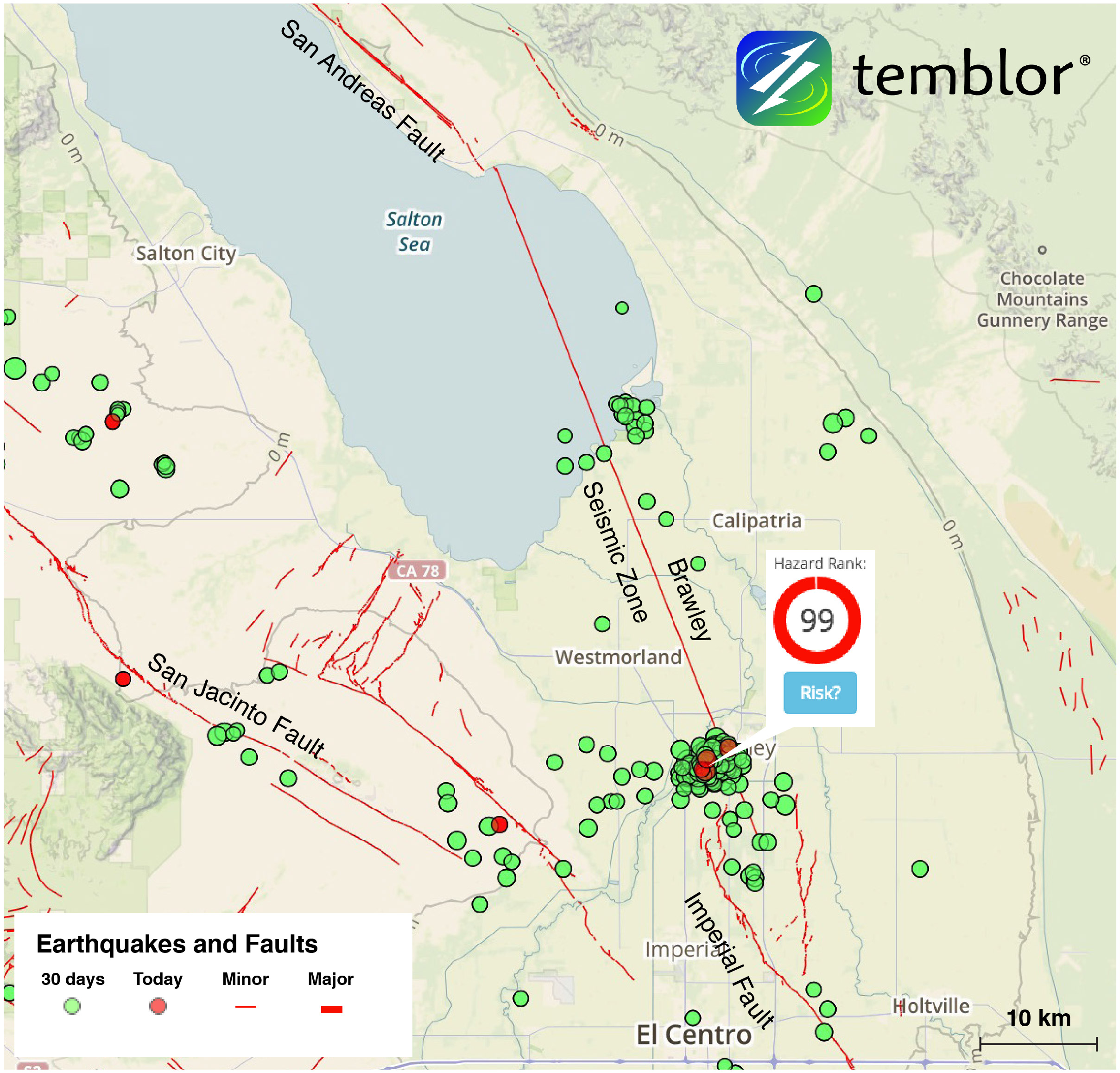
Over the past several days, a swarm of earthquakes has been rumbling the Brawley Seismic Zone, which is the southernmost extension of the San Andreas Fault. As of 11 a.m. on Tuesday January 3, there had been 80 M=2+ earthquakes in three days. Most of these were small, though the largest, a M=3.9, generated strong shaking according to the USGS, and was felt throughout the town.
A seismic swarm is a series of earthquakes, none of which can be identified as the main shock. What this means is that there is no clear decay rate in the number of earthquakes. Swarms are more common in volcanic areas and geothermal sites, both of which are suffused with steam. Swarms also occur along creeping fault sections such as on the San Andreas between Hollister and Parkfield. In general, we think swarms accompany rapid fault creep. Take a look at the time series plot below.


Earthquakes in this portion of California are extremely common as the area, known as the Brawley Seismic Zone, sits between the San Andreas, and Imperial faults. In fact, the Temblor Seismic Hazard Rank is 99 out of 100. The area last saw a large swarm in 2012, when more than 300 quakes shook the region. In 2012, the largest earthquake reached M=5.5. Additionally, in both 1940 M=6.9 and 1979 M=6.5 Imperial Valley Fault earthquakes came very close to rupturing this portion of the seismic zone.


Readers may recognize this area, as it is approximately 45 km southeast of where the September 2016 Bombay Beach Swarm took place, which triggered a one-week earthquake advisory. That alert was issued since it was determined that there was an increased probability of a M=7+ earthquake along the San Andreas Fault.
For this swarm, no earthquake advisory has been issued, perhaps because it is far from Bombay Beach. Nevertheless, if anything should change, we will update you.
Sources
USGS
Southern California Seismic Network (SCSN)
Southern California Seismic Network Bulletin on 2012 Brawley Swarm Click here for bulletin
Wallace, Robert E., ed., 1990, The San Andreas fault system, California: U.S. Geological Survey Professional Paper 1515, 283 p. Click here for paper
Andrew J. Barbour, Eileen L. Evans, Stephen H. Hickman, Mariana Eneva, Subsidence rates at the southern Salton Sea consistent with reservoir depletion, J. Geophys. Res., 121, 5308-5327, doi: 10.1002/2016JB012903 Click here for paper
DeAngelo, J., and Williams, C., Identified Moderate and High Temperature Geothermal Systems of the Western United States including AK and HI, U.S. Geological Survey, Downloadable GIS Data
CNN
The Oklahoman
- Earthquake science illuminates landslide behavior - June 13, 2025
- Destruction and Transformation: Lessons learned from the 2015 Gorkha, Nepal, earthquake - April 25, 2025
- Knock, knock, knocking on your door – the Julian earthquake in southern California issues reminder to be prepared - April 24, 2025