The magnitude-5.9 earthquake reminded residents that Victoria is active — geologically speaking — but identifying the fault responsible is complicated.
By Dee Ninis, Ph.D. (@DeeNinis) and Elodie Borleis, B.Sc. (@borleis), Seismology Research Centre and Tamarah King, Ph.D. (@tamarahking), Oxford University
Citation: Ninis, D., Borleis, E., King, T., 2021, Moderate quake rattles southeastern Australia. Where’s the fault?, Temblor, http://doi.org/10.32858/temblor.207
On September 22, a magnitude-5.9 earthquake near Woods Point, about 80 miles (130 kilometers) east of Melbourne, shook southeastern Australia. Reports of shaking came from as far as Launceston to the south (280 miles or 450 kilometers), Sydney to the northeast (370 miles or 600 kilometers) and Adelaide to the west (465 miles or 750 kilometers). Reported damage includes the collapse of unreinforced masonry outside of buildings in inner-city Melbourne. Fortunately, no lives were lost.
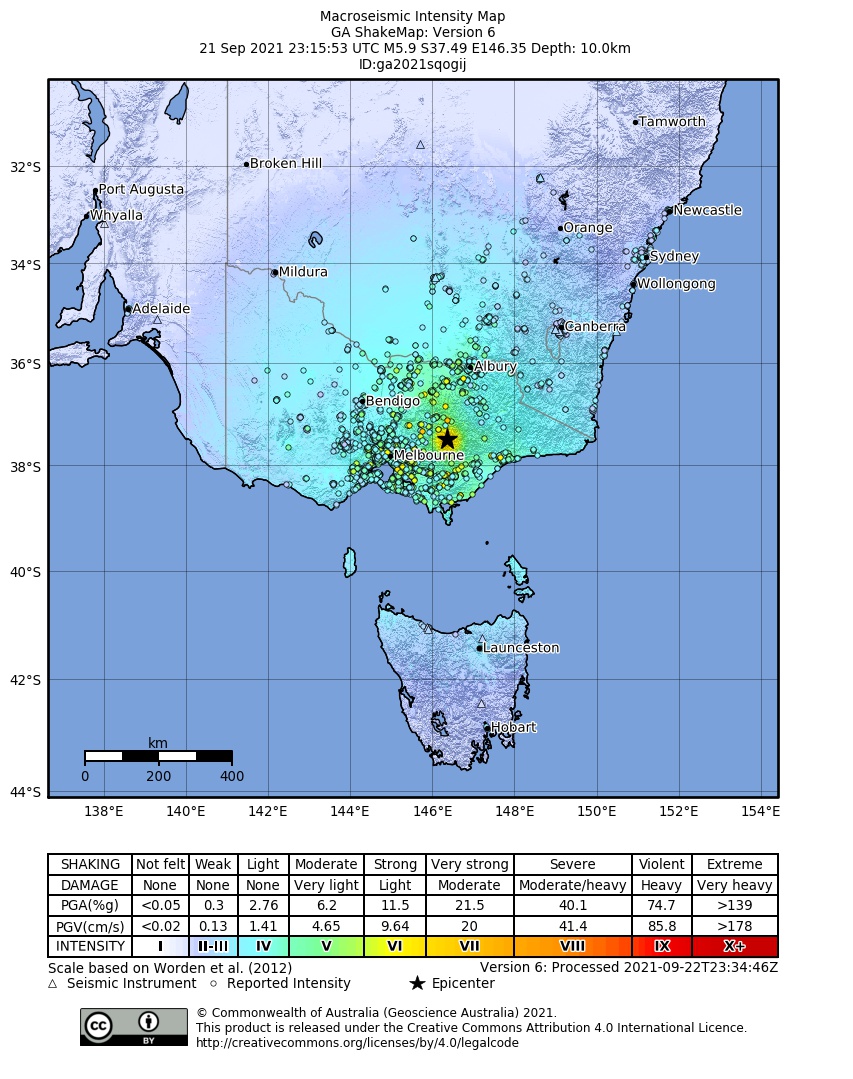
This was the largest onshore earthquake to strike Victoria in at least 150 years — since written records have been kept in Australia. More recently, a magnitude-5.6 quake near Moe in 2012, was widely felt throughout Victoria.
In neighboring New South Wales, a magnitude-5.6 earthquake struck in 1989, 7.5 miles (12 kilometers) below the surface near Newcastle. The quake caused 13 deaths, and remains Australia’s only known fatal earthquake. Widespread destruction caused losses amounting to AUD$4 billion.
Moderate temblors are not unusual
Contrary to popular belief, magnitude-5.9 and larger earthquakes are not unusual for Australia. The country has experienced a magnitude-6.0 or greater earthquake once every roughly 6 years.
The largest Australian earthquakes were those of the 1989 Tennant Creek sequence, which included three events of magnitude-6.2, magnitude-6.3 and magnitude-6.6. All three quakes occurred within a 12-hour period. Other large events include the 1968 magnitude-6.6 Meckering earthquake and a magnitude-6.3 quake near Meeberrie in 1941.
Some studies have identified evidence for ancient ground rupturing magnitude-7.0 or greater earthquakes (e.g., Clark et al., 2007; Ninis & Clark, 2019).

Although Australia is not located along a plate boundary, earthquakes happen for the same reason they do elsewhere: a build-up of elastic strain energy in the crust. As the earth’s crust is stressed, strain energy increases. In Australia, the surrounding plate boundaries transfer their stresses to the interior of the continent. As strain builds up, it must eventually be released. This release happens through movement along weak zones in shallow levels of the crust — namely, faults. But, tectonic processes in stable continental regions such as Australia occur at much slower rates when compared to active plate boundaries, resulting in less frequent earthquakes.
Hundreds of aftershocks rattle Victoria
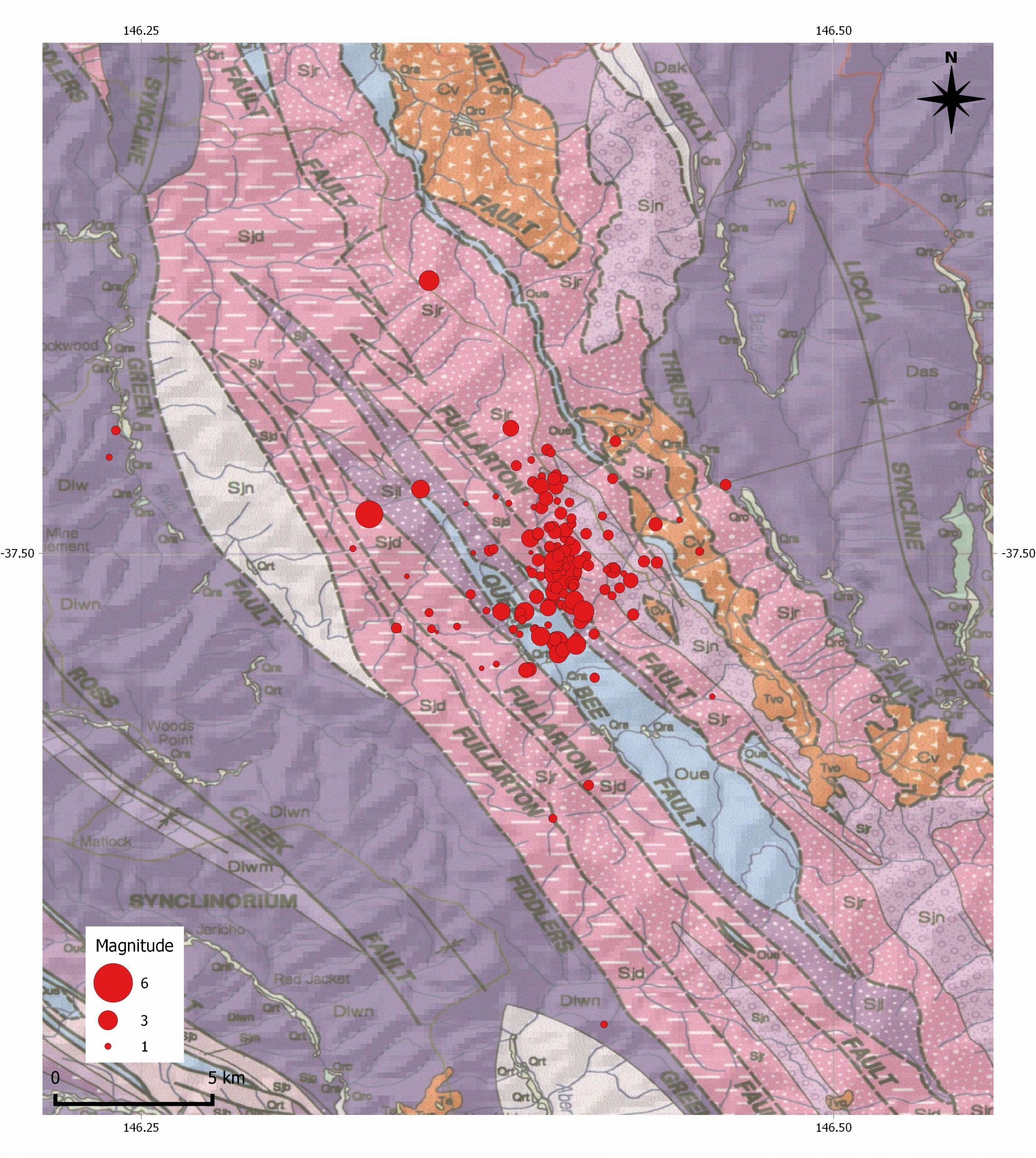
Data recorded by seismometers indicate the Woods Point earthquake occurred at roughly 7.5 miles (12 kilometers) depth, 9 miles (15 kilometers) northeast of Woods Point. In the 24 hours that followed, more than 300 aftershocks struck the region — nearly 100 within the first two hours. Most of these smaller quakes were not noticeable. The largest aftershocks — magnitude-4.2 and magnitude-3.3 — were felt locally. Both struck within an hour of the mainshock.

Locating the fault responsible
The uncertainties associated with earthquake locations and the orientation of nearby faults makes determining what fault was responsible for any given earthquake challenging. Occasionally, a fault will rupture to the surface, which simplifies identification (e.g., the Australian 1968 Meckering and 2016 Petermann earthquakes). We do not yet know if the Woods Point event ruptured the surface. Given the quake’s moderate magnitude and depth, it may not have.
Focal mechanisms, a visual representation of fault slip during an earthquake, calculated by multiple seismic agencies suggest the rupture involved strike-slip movement on a NW-SE trending, steeply dipping fault. The mainshock and aftershocks fall along a roughly NNW-SSE trend, which is consistent with the focal mechanisms and with previous estimates of maximum horizontal stress in the region (e.g., Rajabi et al. 2017).
The current database of Australia’s active geology does not have a fault through the region ruptured by this week’s earthquake. This is not necessarily unexpected – moderate to strong earthquakes on an individual fault in Australia may only recur every 10,000 to 100,000 years, or even more than one million years in some regions (King et al., 2019). Erosion in the mountainous area surrounding Woods Point could easily have erased any evidence of offset on local faults.
The current trend of aftershocks do, however, approximately align with the Governor Fault Zone — a thrust belt that was first active hundreds of millions of years ago. In Victoria, this fault extends more than 186 miles (300 kilometers) from near Echuca in northern Victoria, to near the Gippsland Lakes on Victoria’s southeast coast (VandenBerg, 1997; VandenBerg et al., 2000; Cayley et al., 2002). Results of a recent deep seismic reflection survey (yet to be published) show this structure consists of a complex system of east-dipping faults, including the Fiddlers Green, Fullarton, Queen Bee and Barkly Thrust faults, which merge at depth (Ross Cayley, pers. comm.).
Given the information we currently have, it is possible that this earthquake occurred in this fault zone. Additional forthcoming data may illuminate more evidence of the active structures in the region.
New data to come
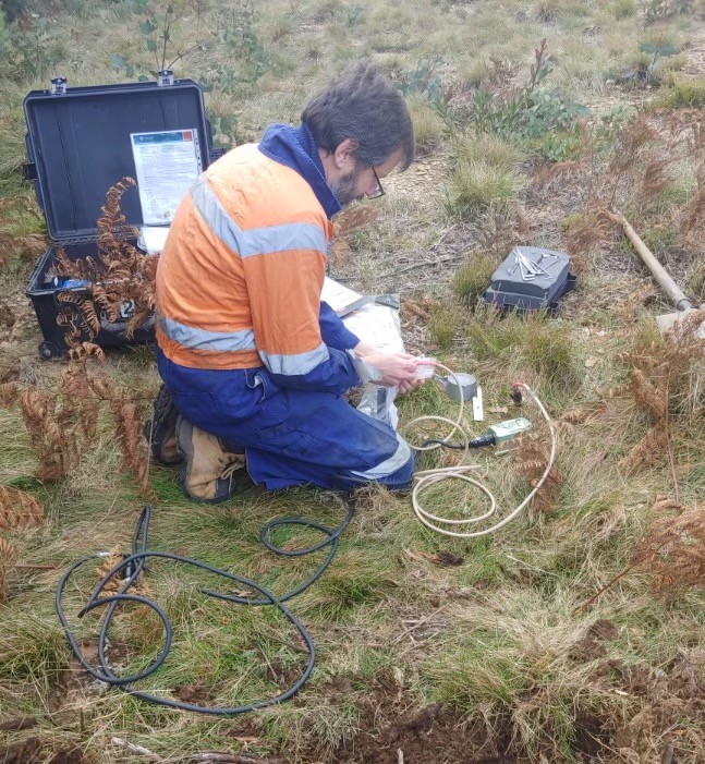
Scientists from Geoscience Australia, the Seismology Research Centre and the University of Melbourne are currently setting up a network of seismometers to monitor aftershocks. The group is exploring the area near the epicenter to search for ground deformation that may have resulted from the mainshock. These observations and soon-to-become-available satellite imagery across the area will hopefully reveal more about the source of this earthquake and, in doing so, may identify a new active fault in Australia.
Acknowledgements: For their insight into the structural geology and crustal stress of the region we thank Ross Cayley of the Geological Survey of Victoria, Dan Clark of Geoscience Australia, and Mojtaba Rajabi of the School of Earth and Environmental Sciences, University of Queensland.
References
Cayley, R.A., Taylor, D.H., VandenBerg, A.H.M. and Moore, D.H., 2002. Proterozoic–Early Palaeozoic rocks and the Tyennan Orogeny in central Victoria: the Selwyn Block and its tectonic implications. Australian Journal of Earth Sciences, 49(2), pp.225-254.
Clark, D., Van Dissen, R., Cupper, M., Collins, C. and Prendergast, A., 2007, November. Temporal clustering of surface ruptures on stable continental region faults: a case study from the Cadell Fault scarp, south eastern Australia. In: Proceedings of the Australian Earthquake Engineering Society Conference, 2007.
King, T.R., Quigley, M. and Clark, D., 2019. The 20th May 2016 Mw 6.1 Petermann surface rupturing earthquake, Australia.
Ninis, D. and Clark, D., 2019. Fault investigation practice in Australia and New Zealand: Why Australian dam owners and operators should care about collecting active fault data. In: Proceedings of the ANCOLD Conference, 2019.
Rajabi, M., Tingay, M., Heidbach, O., Hillis, R. and Reynolds, S., 2017. The present-day stress field of Australia. Earth-Science Reviews, 168.
VandenBerg, A.H.M., 1997. Australia 1:250 000 Geological Map Series, Warburton Sheet SJ 55-6 Edition 2. Geological Survey of Victoria.
VandenBerg, A.H.M., Willman, C.E., Maher, S., Simon, B.A., Cayley, R.A., Taylor, D.H., Morand, V.J., Moore, D.H. and Radojkovic, A., 2000. The Tasman Fold Belt System in Victoria. Geological Survey of Victoria. Special Publication.
- Venezuela’s doublet leaned toward Caracas - June 30, 2026
- Is Southern California’s Cajon Pass an ‘earthquake gate’ ready to open? - June 29, 2026
- Philippines magnitude 7.8 shock may have loaded the central Cotabato subduction zone - June 11, 2026