By David Jacobson, Temblor
Updated: 10 August 2017 at 11 a.m.

At 9:19 p.m. local time (8 Aug), a M=6.5 earthquake struck the Sichuan-Gansu border region in southwestern China. According to both the USGS and the European-Mediterranean Seismological Centre (EMSC), the quake occurred at a depth of 10 km in a mountainous region, near Jiuzhai National Park. This area is on the edge of the Tibetan Plateau and is extremely popular amongst tourists because of spectacular waterfalls and blue and green lakes. So far, 19 people are confirmed to have been killed by this event, and there is photo evidence of significant damage, which the USGS PAGER system estimates could be moderate to high near the epicenter, where very strong shaking was recorded.

Now that a few days have past, new photography which has come in from the area, illustrating that damage in nearby Jiuzhai National Park is significant (See below). This area brings in a significant amount of money to the area from tourism, and with the damage sustained, local officials are worried about the health of local businesses. At the time of the earthquake, local officials say there were 30,000 tourists in the area. The majority of these people have been evacuated and tourists are told to stay away.


Based on the USGS focal mechanism, the M=6.5 earthquake was strike-slip with a thrust component. However, at this time we cannot be sure of the strike of the fault on which the quake occurred due to location inconsistencies between the USGS and EMSC and the numerous lineaments in the area. In this portion of the Tibetan Plateau, fault motion is dominated by left-lateral strike-slip faults, including the Altyn Tagh, Kunlun, and Haiyuan fault zones. Additionally, the location of the earthquake is approximately 280 km northwest of the epicenter of the 2008 M=7.9 Wenchuan earthquake which killed over 87,000 people. That earthquake occurred on the Longmenshan Fault, and was a thrust (compressional) event.
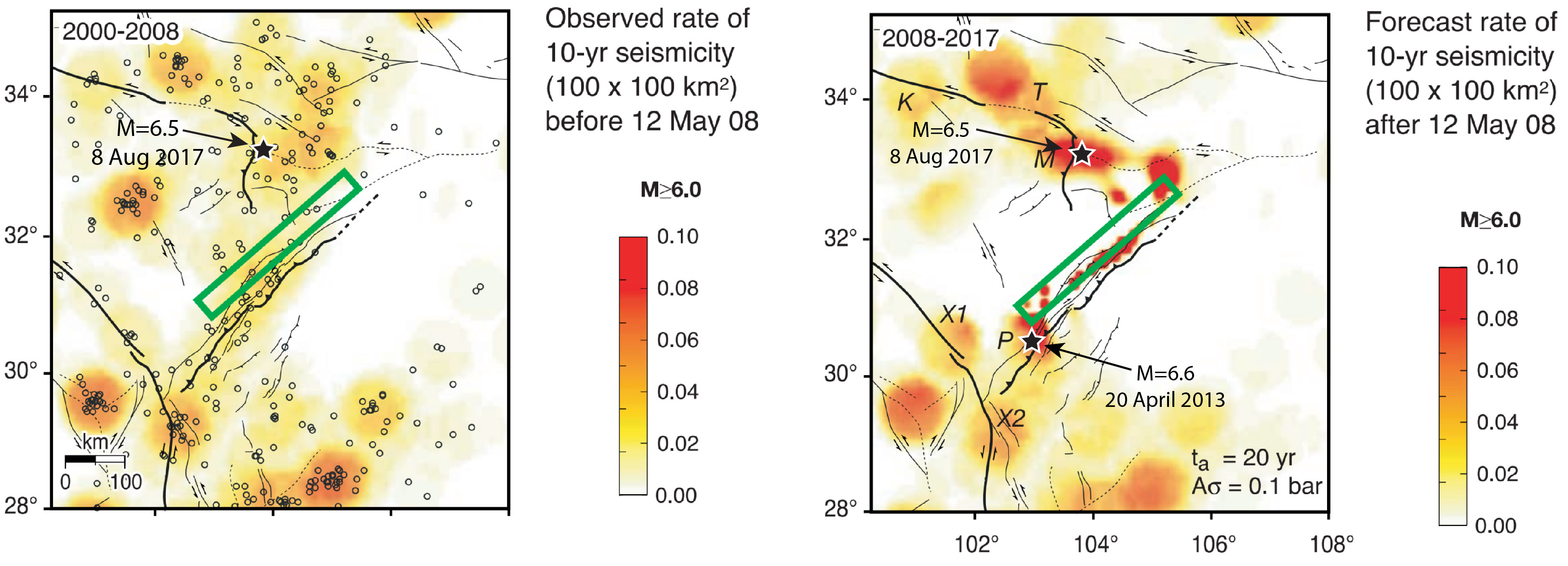
Even though the earthquake struck nearly 300 km from the Wenchuan earthquake, based on the figure below, one can see that this area saw a significant stress increase, which more than doubled the likelihood of a M=6+ earthquake. The side-by-side figures below show the observed rates of seismicity prior to the Wenchuan earthquake (left), and the forecasted seismicity in the 10 years following as a result of the stress imparted by the Wenchuan (The location of the August 8th quake is labeled with a star). This comparison shows that due to the Wenchuan earthquake, the area around today’s event went from having a 4% chance of experiencing a large quake, to 10%.
Based on the Global Earthquake Activity Rate (GEAR) model, which is available in Temblor, this earthquake can be seen as surprising. This model uses global strain rates and the last 40 years of seismicity to forecast the likely earthquake magnitude in your lifetime anywhere on earth. In the figure below, one can see that GEAR would forecast a M=5.75 earthquake in this region, significantly lower than the magnitude (M=6.5) of this event. This illustrates the importance of incorporating stress transfer into the likelihood of experiencing large earthquakes. GEAR does not, which is why it would see this quake as surprising.

References
USGS
European-Mediterranean Seismological Centre
Shinji Toda, Jian Lin, Mustapha Meghraoui, and Ross S. Stein, 12 May 2008 M = 7.9 Wenchuan, China, earthquake calculated to increase failure stress and seismicity rate on three major fault systems, GEOPHYSICAL RESEARCH LETTERS, VOL. 35, L17305, doi:10.1029/2008GL034903, 2008.
- Earthquake science illuminates landslide behavior - June 13, 2025
- Destruction and Transformation: Lessons learned from the 2015 Gorkha, Nepal, earthquake - April 25, 2025
- Knock, knock, knocking on your door – the Julian earthquake in southern California issues reminder to be prepared - April 24, 2025