By David Jacobson, Temblor

At 7:44 a.m. today, a M=4.5 earthquake struck just north of the Portuguese capital of Lisbon. While no damage was caused by the quake, it was strong enough to set off Twitter as the region is a popular tourist hotspot. Many of the tweets referred back to a M=8.5-9.0 earthquake in 1755, in which 10,000-100,000 people were killed, a deadly tsunami was triggered, and the majority of Lisbon was destroyed. This remains one of the deadliest earthquakes ever, and is the largest earthquake in European history.
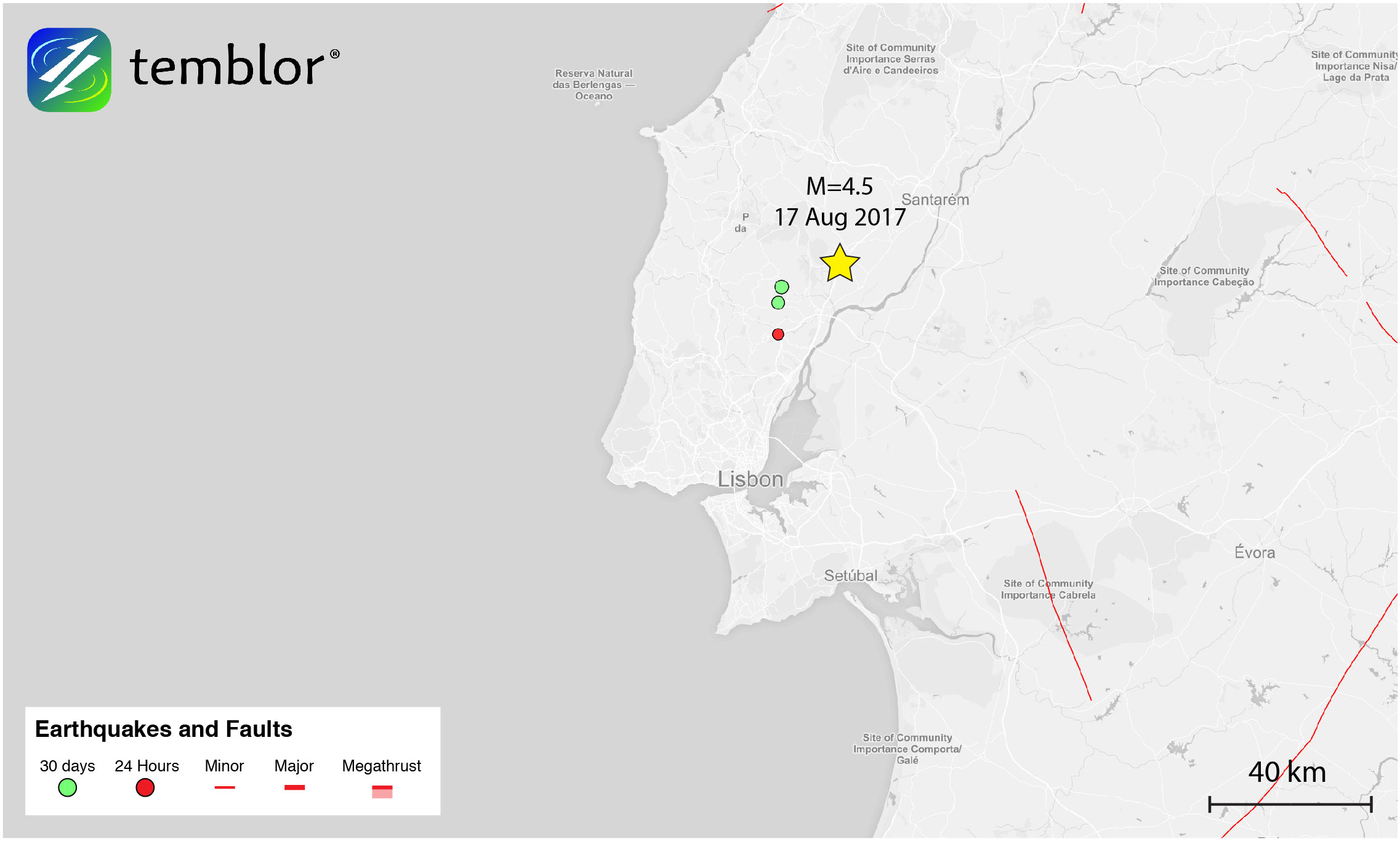
In the Temblor map above, one can see that in addition to today’s M=4.5 earthquake and a small quake two hours later, there are two other events which occurred two days ago. Because of this sequence of events, the seismic activity around Lisbon can be classified as a swarm. And, because swarms can precede larger earthquakes, highlighting this relatively small event is important, especially given Lisbon’s tectonic hazard.
The figure below shows a seismic hazard map for the Iberian Peninsula created by the Seismic Hazard Harmonization (SHARE) project. This map takes into account earthquakes from the last 1,000 years, as well as known active faults across the continent. What this map shows is that the area Lisbon has the highest seismic hazard of any region in Portugal. This is likely due to the fact that within the Lower Tagus Valley, which is where Lisbon is located, there are several active faults, capable of rupturing in M=6.5-7 earthquakes (These faults are not shown in Temblor, but were considered in the creation of the SHARE map). The consideration of faults and earthquakes going back 1,000 years is why the SHARE model shows a seismic threat for this region and the Global Earthquake Activity Rate (GEAR) model does not. GEAR only looks at the last 40 years of seismicity, and because strain rates in the region are very low, it is assigned a background rate similar to that of other tectonic plate interiors. To view the GEAR model, click here.

While a M=6.5-7 earthquake pales in magnitude compared to the great 1755 earthquake, fault rupture on one of the Lower Tagus Valley faults could be as devastating to the city. This is because the 1755 earthquake struck offshore, 300-400 km from Lisbon. That quake, originating on the Africa-Eurasian plate boundary, also generated a tsunami with waves up to 12 m high, something an earthquake on the Lower Tagus Valley faults would not do. Nonetheless, what these faults and past events highlight is that the Iberian coast is susceptible to large earthquakes, and that the seismic hazard must be taken seriously.
References
European-Mediterranean Seismological Centre (EMSC)
Seismic Hazard Harmonization in Europe (SHARE)
Scientific American
Mendes-Victor, L.; Carvalho, J.; Goncalves, R.; Cabral, J., The Lisbon-Vila-Franca de Xira Fault System Revisited, Portugal, American Geophysical Union, Fall Meeting 2005, abstract #T22C-08
Roy Barkan, Uri S. ten Brink, Jian Lin, Far field tsunami simulations of the 1755 Lisbon earthquake: Implications for tsunami hazard to the U.S. East Coast and the Caribbean, Marine Geology 264 (2009) 109–122
- Earthquake science illuminates landslide behavior - June 13, 2025
- Destruction and Transformation: Lessons learned from the 2015 Gorkha, Nepal, earthquake - April 25, 2025
- Knock, knock, knocking on your door – the Julian earthquake in southern California issues reminder to be prepared - April 24, 2025