By David Jacobson, Temblor
See earthquakes in New Zealand

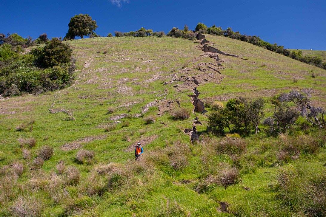
In last month’s M=7.8 Kaikoura, New Zealand earthquake, at least 9 separate faults ruptured in the largest quake in New Zealand since the 1855 M=8.2-8.3 Wairarapa earthquake. In a matter of seconds the New Zealand landscape changed forever. Shore platforms along the coast were uplifted, landslides blocked rivers and roads, and large intermittent surface ruptures extended for over 120 km.
In the aftermath of the quake, scientists scrambled to not only figure out which faults ruptured, but how at least 9 different faults could rupture simultaneously. Additionally, because of the incredible surface traces and landslides, this earthquake provided an opportunity to document an earthquake better than ever before.
Thanks to Dr. Kate Pedley, a lecturer at the University of Canterbury in Christchurch, New Zealand, we are able to share some of the incredible imagery captured following the November 14th quake. Kate’s photos have already circulated the globe, and we wanted to share some additional photos to showcase the incredible power of this earthquake.


To document the quake, scientists in New Zealand have been carefully mapping earthquake features, measuring fault offset, and noting which faults ruptured (and which didn’t). By doing this, they could create the most comprehensive dataset of any fault rupture.
This earthquake not only provides an opportunity for stunning documentation, but raises several questions. Some of these include how and why at least 9 faults ruptured in a single event, and, are all these faults within the Marlborough Fault System linked at depth? Scientists do know that they merge with the Alpine Fault to the southwest, but their interaction at depth is less known.
Using the finite fault model produced by the USGS, we can at least gauge if merging the faults at depth is plausible. In the model, the failure structure in the November 14th event had a dip of 38 degrees to the northwest, and ruptured at a depth of 22 km. Based on the strike of this structure and the surface traces of the faults which ruptured, intersection would take place at a minimum depth of 18-28 km. While this number could fluctuate based on fault dip at depth, it does at least suggest that a large, singular structure could be the reason why so many faults ruptured. However, additional research and data is required to verify this finding. One of the principle reasons why determining the rupture dynamics in this earthquake is important is because it could improving our understanding of hazards associated with large-scale fault systems, and how faults can interact with one another.
The video below shows GNS scientist Kelvin Berryman explaining the fault rupture on the Papatea Fault.
Sources:
GNS Science
GeoNet New Zealand
University of Canterbury
USGS
New Zealand Geographic
- Earthquake science illuminates landslide behavior - June 13, 2025
- Destruction and Transformation: Lessons learned from the 2015 Gorkha, Nepal, earthquake - April 25, 2025
- Knock, knock, knocking on your door – the Julian earthquake in southern California issues reminder to be prepared - April 24, 2025