Densely spaced seismic monitoring stations and a ready-made alerting system allow warnings to be issued within seconds of an earthquake larger than magnitude-4.5.
By Elisabeth Nadin, University of Alaska Fairbanks
Citation: Nadin, E., 2022, Israel to get earthquake early warnings, Temblor, http://doi.org/10.32858/temblor.244
When you think of Israel, earthquake destruction probably does not leap to mind. Although earthquakes are common enough, in this region they tend to clock in at magnitudes of less than 4. Still, every decade on average there’s a magnitude-5 or above, and every hundred years or so, the country is hit with a quake of magnitude 6 or greater. The last fatal event, a magnitude-6.2 in 1927, killed more than 250 people in northern Israel.
With the centennial of the 1927 so-called Jericho earthquake looming, the Israeli government tasked the country’s geological survey with designing an earthquake early warning system. That system, called TRUAA after the Jewish New Year blast of the ram’s horn, launched last month.
“I don’t think there’s a system like this anywhere in the world,” says project manager Ittai Kurzon, a seismologist with the Geological Survey of Israel. The seismic stations are closely spaced, at five to 10 kilometers (three to six miles) apart, in part because Jerusalem lies only 30 kilometers (19 miles) from the Dead Sea Fault, and in part because the country is so narrow.
Although the risk of large, destructive earthquakes in Israel is one-tenth that in California, Kurzon says, “you only need one event of magnitude 6+ to cause a lot of damage, and today Israel is at least ten times more populated than it was in 1927.”
Seismic unrest
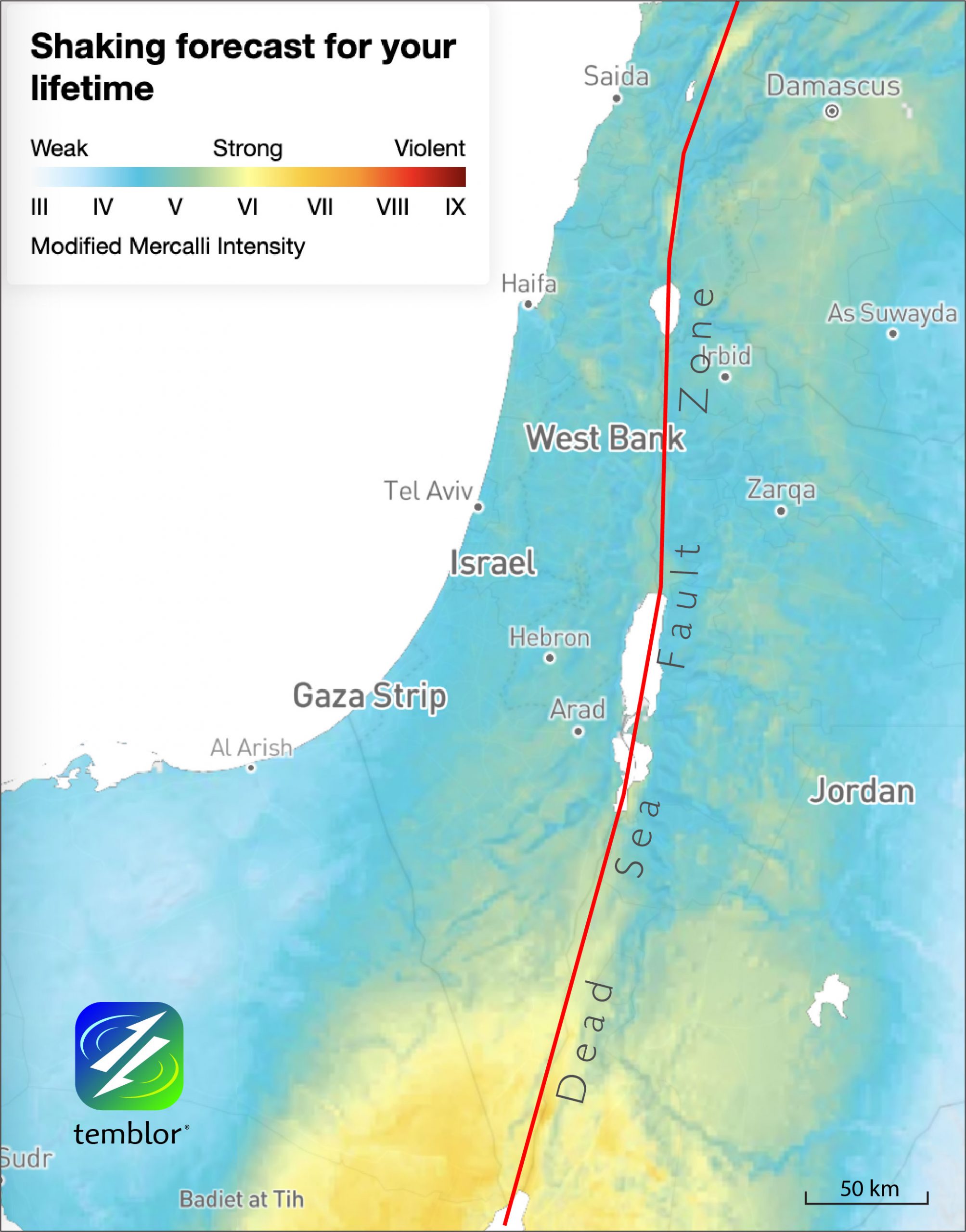
The main earthquake source in Israel is the Dead Sea Fault and its associated branches, one of which is the Carmel-Zfira Fault, which forms the boundary between the African and Arabian tectonic plates. This fault system runs from Turkey in the north, through the Sea of Galilee and the Jordan Valley, past Jerusalem and into the Gulf of Aqaba in the south. It is thought to be capable of producing magnitude-7.5 earthquakes. The 1995 Gulf of Aqaba earthquake, a magnitude-7.3 at the border of Egypt and Saudi Arabia, caused significant damage in Israel’s southernmost city, Eilat. In short, Israel has a high seismic risk, says Renate Hartog, manager of the Pacific Northwest Seismic Network.
Regular reminders of the region’s seismic unrest, including a July 2018 earthquake swarm that culminated in a magnitude-4.7 quake, spurred station installations by the survey. By the end of 2019, there were 100 stations, 80 of which were installed along the Dead Sea Fault. Today, there are 120.
Similar yet different
In 2012, an international committee on earthquake preparedness recommended Israel develop an earthquake early warning system. Kurzon, the first seismologist ever employed by the survey in Israel, knew that to make this happen, the country needed to substantially increase the number of seismic stations. The plans were laid out within five years: 25 stations would grow to 120, and the survey would contract Canada’s Nanometrics, Inc. to deploy the seismic stations and integrate them into a real-time seismic network.

TRUAA is based on similar earthquake early warning setups in Japan and the U.S. West Coast. It mimics the EPIC system, developed over a decade by California’s ShakeAlert program and launched in 2019. These systems require four stations close to the epicenter to receive the first seismic waves, the P waves, quickly enough to determine the earthquake’s location and magnitude. “You catch [the earthquake] when it’s a baby with the P, and you can generate the warning before it grows,” says Kurzon.
The denser the network, the faster the P waves are caught and the earthquake properties calculated, and the faster a warning can be issued. Each of TRUAA’s 120 stations is equipped with a three-channel accelerometer to determine the level of shaking. Twenty-five stations have broadband sensors — to determine seismic wave speeds and provide higher network sensitivity and broader frequency range — and nine stations have geodetic antennae to precisely determine earthquake locations and displacements during shaking.
“The denser our network near the source, the faster we can get the message out,” says Kurzon.
“Other places in the world would struggle to achieve such density, merely due to the size of the country,” says Ran Nof, a hazards researcher with the Geological Survey of Israel. “Having an expensive seismic station every five kilometers is much easier to achieve when the faultline is only 450 kilometers.”
TRUAA’s setup — fast alerts
Another distinguishing feature of TRUAA is the warning system, which passes through the ever-ready military communications network. For an effective alert system, automatic telecommunication of the earthquake information, called telemetry, is needed. A 2020 publication in Seismological Research Letters authored by Nof and Kurzon details the new setup.
Data from the stations are multicast from two of three systems: ethernet, cellular or satellite. The primary path takes 400 milliseconds; the secondary backup arrives within 1.5 seconds. The data are received at all data centers.
Once an earthquake alert is generated by the seismic stations, the signal goes to the Israeli Defense Force’s Home Front Command, which issues the early warning alert to citizens through an app, allowing people precious seconds to react before the more destructive S waves strike. Distribution goes through the same network that warns residents of impending rocket attacks. Travel time to cell-phone apps, emergency sirens, TV and radio adds an additional 1–10 seconds.
So how does this all play out in real time? Say there is an earthquake near the Sea of Galilee in northern Israel. First, if it is below magnitude 4.5, residents in the area might feel shaking but they would not get an alert. The system is set up to only alert for larger quakes. The survey balanced the risk that not issuing an alarm when people feel shaking would undermine their confidence in the system against the risk that issuing warnings for minimal threats could lead to indifference when the big one comes. “If you put it too low, then every magnitude-3 would make you jump,” says Kurzon. And, as Nof points out, the more accurate the warning system, the more the government and population values its utility.
Above magnitude 6, the alert goes nationwide. Between magnitudes 4.5 and 6, the Home Front Command issues the message according to how the earthquake is shaking the ground in a particular location. As magnitude estimates are updated, the “alert radius” expands. Where stations are denser, along the Dead Sea Fault, an alert will be heard within 5 five seconds. Elsewhere in Israel, where the seismic hazard is lower and there are fewer stations, it may take closer to eight seconds.

Practical limitations
“Because the country is relatively small and cities are close to the faults, there will be very little time to disseminate an alert that will arrive before people feel strong shaking,” notes Hertog.
Additionally, there is a significant late alert zone — the area so close to the epicenter that seismic waves shake the ground before any alert can be generated. Its radius is about 22 kilometers (14 miles) near the densest part of the seismic network. “If there’s an earthquake in the northern Dead Sea, Jerusalem would only have three seconds of alert,” says Kurzon. Private companies have devised micro-electronic systems that the Ministry of Education installed in schools that lie closer to the active fault system. And, says Nof, exercises that train people how to react when they hear an alert should be an integral part of an early warning system.
It is difficult to imagine improvements that could decrease the time it takes to issue a warning, but Kurzon says that denser station spacing, particularly in southern Israel, could shave a couple of seconds from the alert time. Hertog says that the EPIC algorithm does best when seismic stations surround the source, but Israel has stations mostly to one side of the Dead Sea Fault. “The fault is shared between us and Jordan, and if we could cooperate with Jordan and the Palestinian Authority, then their networks could be added,” says Kurzon.
Another possible improvement would be connecting the TRUAA system to automated decision modules of infrastructure that exists for trains, gas lines and power systems. “Different infrastructures would require different decision schemes, at different levels of risk mitigation,” says Kurzon. They could include slowing down trains, preventing airplanes from landing, shutting off gas valves and more. Such systems exist in Japan, in which the national alert system is fed into internal decision modules at various companies, allowing them to provide risk mitigation for their customers.

Early warning systems in other parts of the world evolve as new earthquakes ferret out flaws in station geometry, algorithm configurations or alerting strategies. “The relatively low rate of background seismicity [in Israel] limits how well they can test the system to make sure it performs well when it is really needed,” says Hertog.
Nof and colleagues at Tel Aviv University are working on a new effort to optimize the warning system, by reducing the number of stations needed to confidently issue an alert, which currently sits at four.
“We must remember that earthquakes are a natural hazard; we cannot stop earthquakes,” says Nof. Early warning systems are one of several tools to prevent damage and loss of lives.
References
Nof, R. N., & Kurzon, I. (2021). TRUAA—Earthquake early warning system for Israel: Implementation and current status. Seismological Research Letters, 92(1), 325-341.
- Venezuela’s doublet leaned toward Caracas - June 30, 2026
- Is Southern California’s Cajon Pass an ‘earthquake gate’ ready to open? - June 29, 2026
- Philippines magnitude 7.8 shock may have loaded the central Cotabato subduction zone - June 11, 2026