David Jacobson and Ross Stein, Temblor
The M=6.2 Italy earthquake dominated the seismic headlines today, but an even larger quake just a few hours later was largely ignored. While unrelated, both earthquakes are important.
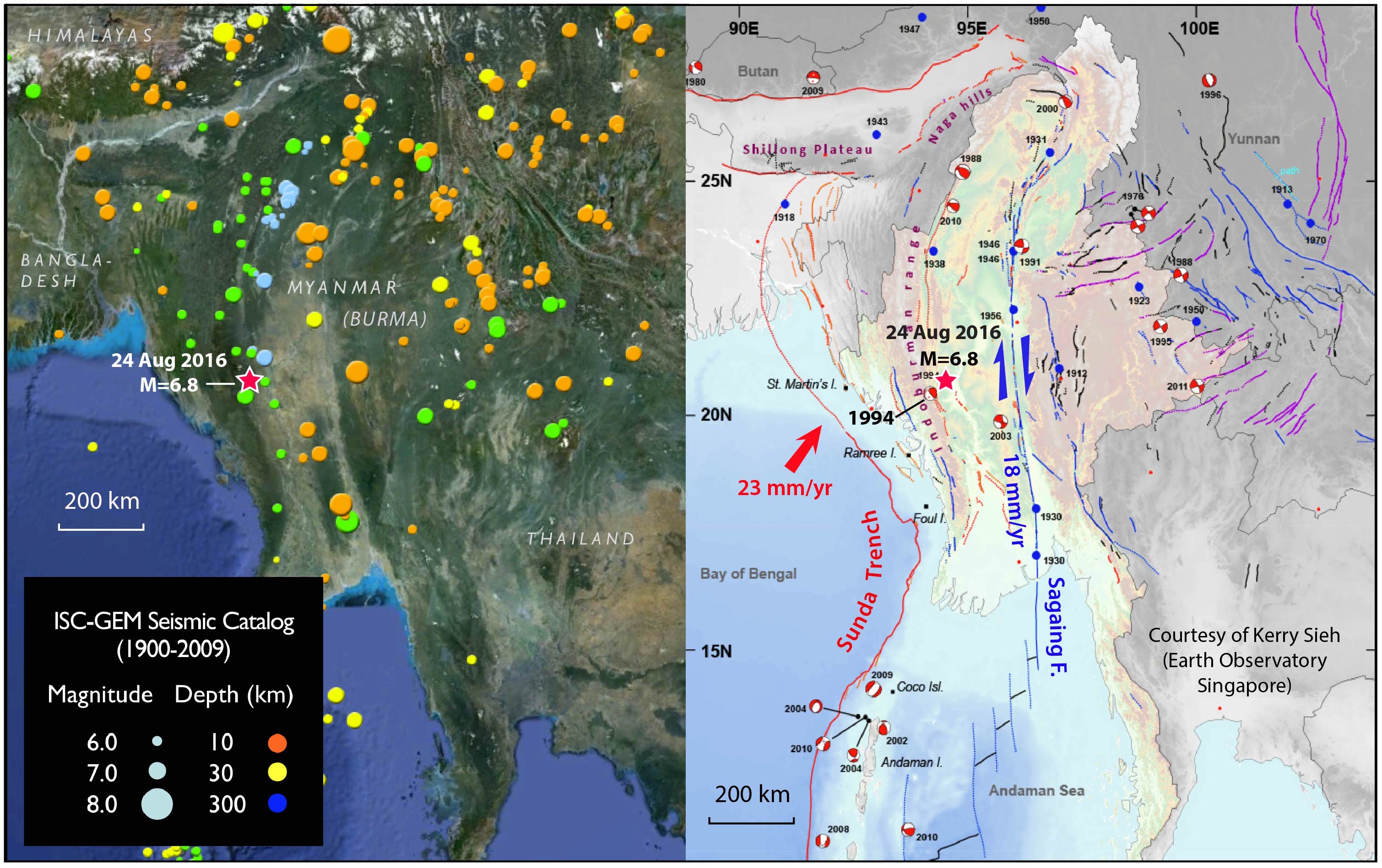
Today’s magnitude 6.8 earthquake struck western Burma, 200 km northwest of the capital city of Naypyitaw. This quake, which took place at 5:04 p.m. local time (3:34 a.m. PDT), occurred at a depth of 85 km and was felt as far away as Bangladesh. From the Temblor map below, we can see that earthquakes of this size are not unusual for the region. Though reports are still coming in, 3 people are already confirmed dead and several ancient temples have seen significant damage.

This earthquake, which occurred on a thrust fault, also illuminates the regional tectonics of the area. Burma lies in a zone of competing tectonic forces. The Indian plate is subducting (or shoving itself) obliquely beneath Burma at 23 mm/yr (about an inch a year). This is accommodated by twin parallel faults: The highly active Sagaing Fault is a right-lateral transform fault, not unlike the San Andreas in California, and accommodates 11-18 mm/yr of motion. The remainder, also about 18 mm/yr, occurs as pure subduction between the Burma and Sunda plates. Given the location and depth (85 km), today’s earthquake would require the subducting plate to have an average dip of 18°.
An 85 km hypocentral depth is fairly deep compared to most large subduction zone earthquakes, which typically occur at depths of less than 45 km. This greater depth means that while shaking lasted for up to 2 minutes, intensities were lower, resulting in less damage.
From the map above on the right, we can see that the region around the epicenter experiences both compressional and shear stresses. In fact, a 1994 M=6.5 earthquake located very near the epicenter of today’s earthquake, had a significant component of strike-slip motion. The 1994 shock was much shallower that today’s, and was likely located within the overriding crustal block. This variety of events illustrates the tectonic complexity of the region, which is not only being squeezed, but twisted, resulting in a diversity of earthquake motion.
Over the past decade, Kerry Sieh and his colleagues at Earth Observatory Singapore have mapped all of the active faults in the region, training Burmese geologists and paleoseismologists along the way. At the same time, Susan Hough and her USGS colleagues have been training Burmese seismologists and introducing seismic instrumentation, funded by the U.S. Office of Foreign Disaster Assistance. We anticipate that both of these researchers will provide more insights in the month ahead, and that the cohort of scientists they have trained will lead their country’s understanding of and preparations for its very high seismic hazards.
Sources
USGS, Earth Observatory Singapore, BBC, New York Times
- Earthquake science illuminates landslide behavior - June 13, 2025
- Destruction and Transformation: Lessons learned from the 2015 Gorkha, Nepal, earthquake - April 25, 2025
- Knock, knock, knocking on your door – the Julian earthquake in southern California issues reminder to be prepared - April 24, 2025