
A major earthquake that struck on May 22, 2026, caused multiple rockslides, damage to homes and power outages. The earthquake was the largest on the Big Island since a magnitude 6.9 earthquake in 2018.
By Taiyi Wang, Postdoctoral Research Associate, California Institute of Technology
Citation: Wang, T., 2026, Magnitude 6.0 earthquake strikes the Big Island of Hawai’i, Temblor, http://doi.org/10.32858/temblor.376
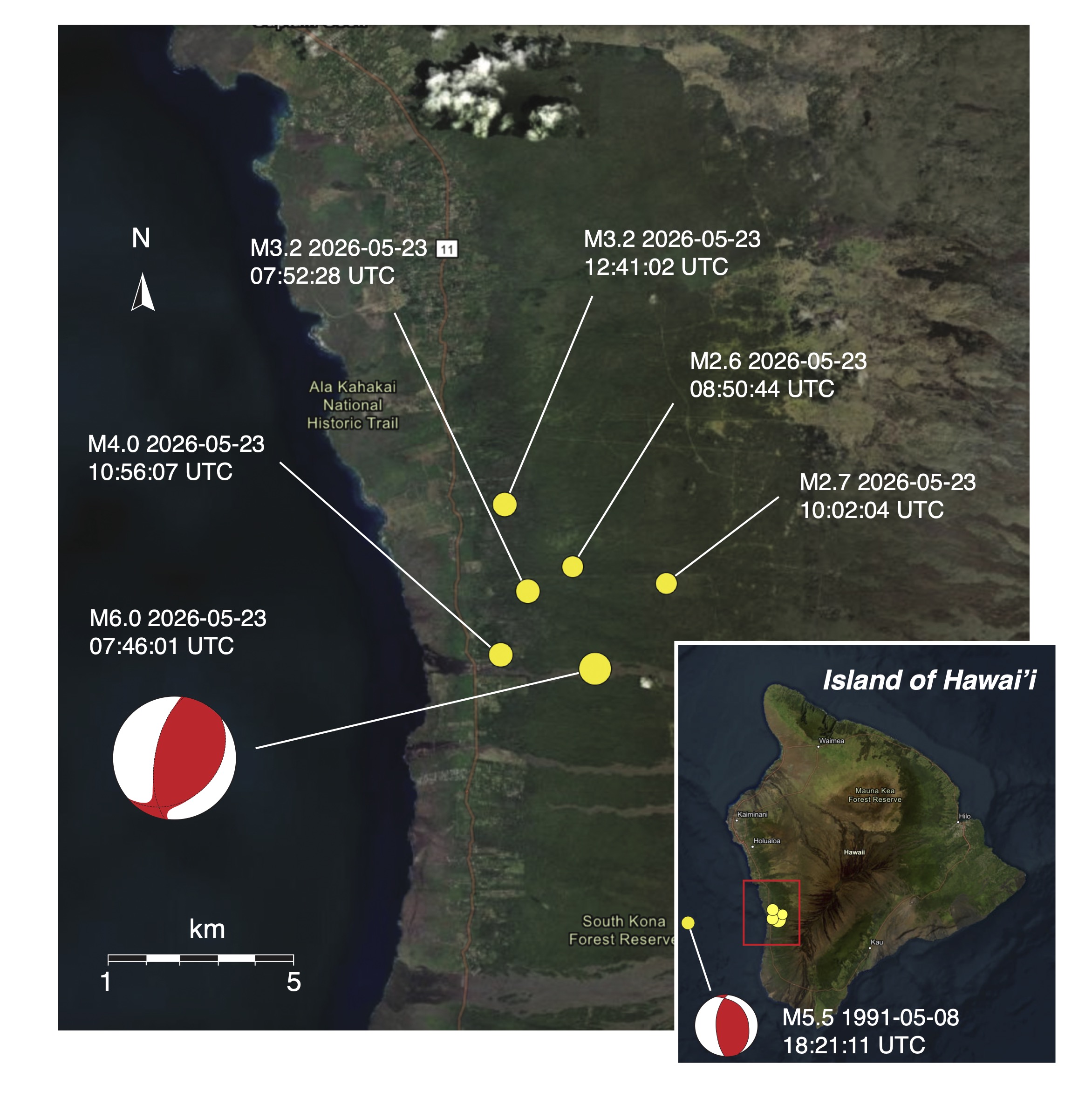
On May 22, 2026, at 9:46 p.m. local time, a magnitude 6.0 earthquake occurred near Hōnaunau-Nāpōʻopoʻo below the west side of the Big Island of Hawai’i. The U.S. Geological Survey reports a hypocenter depth of 22.6 kilometers, which indicates that the earthquake nucleated in the mantle. The earthquake was followed by at least five aftershocks, the largest of which was a magnitude 4.0 approximately 3 kilometers west of the mainshock (Figure 1).
In this contribution, I briefly explore what happened and what it tells us about the tectonics of Hawaii. Of importance, this earthquake and its associated aftershocks are too deep to be related to shallow magma movement beneath the island’s volcanoes.
Details, décollements and diving boards
The focal mechanism solution (also known as a beachball diagram) reported by the USGS for the magnitude 6.0 earthquake indicates reverse faulting (Figure 1) — the type of fault movement where the upper block of the fault slides upward along a sloped fault surface relative to the lower block of the fault. In other words, the two fault blocks are converging. The focal mechanism indicates that fault motion is converging predominantly in the west-east direction.
The earthquake is well below the so-called décollement, which is a nearly flat-lying fault system underlying much of the Big Island. The décollement separates the volcanic rocks comprising much of the island from the underlying oceanic crust. Whereas the planar décollement is the source of numerous earthquakes around the island, it does not appear to be the cause of the latest shock.
The magnitude 6.0 earthquake shares similarities with a magnitude 5.5 earthquake that occurred on May 8, 1991. Both events struck under the west side of the Big Island (Figure 1, inset). Both earthquakes occurred in the mantle; the 1991 magnitude 5.5 earthquake had a hypocenter depth of 28.9 kilometers, whereas the recent event occurred at a depth of with 22.6 kilometers. Both earthquakes exhibited reverse faulting as a result of convergence in the west-east direction.
An explanation for the magnitude 5.5 earthquake in 1991, and plausibly the magnitude 6.0 earthquake on May 22, is the so-called flexural stress model (Rogers, 1977; Klein et al., 1987; Pritchard et al., 2007). Conceptually, this model is akin to how a diving board bends because of the weight of the diver: The top of the board behind the diver extends while the underside of the board compresses (visualization in Figure 2a; recall that weight is a force, and depends on mass and the pull of gravity).
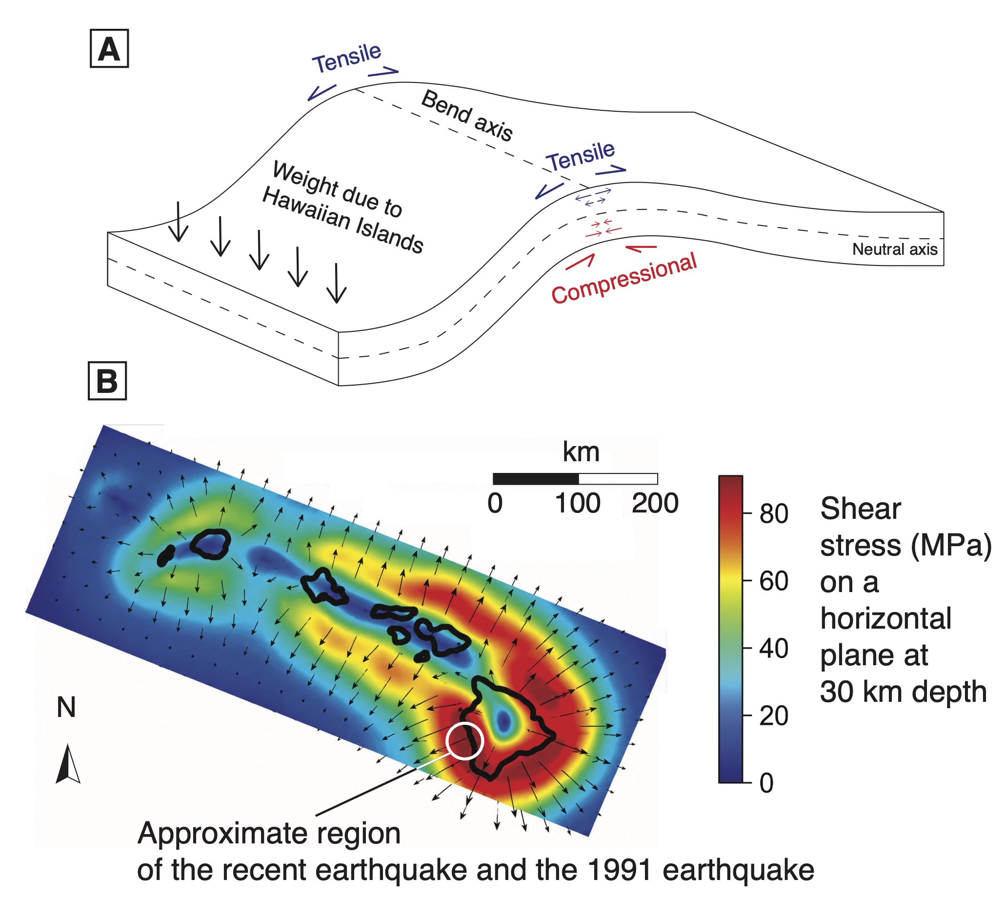
By analogy, the Hawaiian Islands provide the weight that bends the diving board; the top of the diving board is the oceanic crust, under tension, and the underside of the diving board is Earth’s (lithospheric) mantle, under compression. This uppermost part of the mantle hosts faults, much like a heavily used diving board that forms cracks over time. These faults form in orientations that are consistent with the stress field, which, in the case of this compression, produces faults dipping gently toward the weight — the Hawaiian Islands. The compression’s shear stress component can drive the faults to failure.
Pritchard et al. (2007) modeled the stress below the Hawaiian Islands due to the flexure of the oceanic crust and the mantle. One of their results, the shear stress on an imaginary horizontal plane at 30 kilometers depth below the Hawaiian Islands, is shown in Figure 2b. Here, the imaginary horizontal plane represents mantle faults that may exist at that depth. The region of particular interest is the west side of the Big Island, where the earthquakes occurred. In this region, the directions of shear traction (the shear stress exerted by an imaginary upper block on the lower block) is indeed consistent with the west-east-convergent focal mechanisms of both the magnitude 6.0 and magnitude 5.5 earthquakes (Figure 2b).
Hazards
The May 2026 magnitude 6.0 earthquake is unlikely to be related to shallow (less than 10 kilometers) magmatic activities of the nearby volcanoes — Hualālai and Mauna Loa. The earthquake occurred at too great a depth.
The earthquake did not trigger tsunamis. Earthquakes can generate tsunamis when they rupture the seafloor, causing sudden motions that displace large volumes of seawater. A magnitude 6.0 earthquake typically has rupture radius smaller than 10 kilometers. Given that the hypocenter is more than 20 kilometers deep, fault rupture likely did not to reach the seafloor.
The major hazards associated with earthquakes like the 1991 and 2026 events are related to shaking. As of this writing, the USGS has received more than 7,000 “Did You Feel It” reports. The strongest shaking reported thus far corresponds to a VII on the Modified Mercalli Index — very strong shaking. If you felt it (or didn’t but were nearby), please tell the USGS.
Science Editor: Alka Tripathy-Lang
Reviewers: Ross Stein, Paul Segall
References
Klein, F. W., Koyanagi, R. Y., Nakata, J. S., & Tanigawa, W. R. (1987). The seismicity of Kilauea’s magma system. Volcanism in Hawaii, 2, 1019-1185.
Pritchard, M. E., Rubin, A. M., & Wolfe, C. J. (2007). Do flexural stresses explain the mantle fault zone beneath Kilauea volcano?. Geophysical Journal International, 168(1), 419-430.
Rogers, D. B., & Endo, E. T. (1977). Focal mechanisms for upper mantle earthquakes and flexure of the lithosphere near Hawaii. Eos Trans. AGU, 58, 1231.
Wolfe, C. J., Okubo, P. G., Ekström, G., Nettles, M., & Shearer, P. M. (2004). Characteristics of deep (≥ 13 km) Hawaiian earthquakes and Hawaiian earthquakes west of 155.55° W. Geochemistry, Geophysics, Geosystems, 5(4).
Copyright
Text © 2026 Temblor. CC BY-NC-ND 4.0
We publish our work — articles and maps made by Temblor — under a Creative Commons Attribution-NonCommercial-NoDerivatives 4.0 International (CC BY-NC-ND 4.0) license.
For more information, please see our Republishing Guidelines or reach out to news@temblor.net with any questions.

- Is a doublet signaling the formation of a new basin in Sındırgı, Western Türkiye? - August 11, 2026
- Venezuela’s doublet leaned toward Caracas - June 30, 2026
- Is Southern California’s Cajon Pass an ‘earthquake gate’ ready to open? - June 29, 2026