By David Jacobson, Temblor

Not just sea level rise
Over the next several decades, one of the greatest impacts to coastal areas will be sea level rise. This is not only because at the current rate of 3.1 mm/yr many coastal cities will experience regular flooding, but because factors like local land subsidence will exacerbate the flooding’s reach. One of the areas that could bear the brunt on this is the Bay Area. In a recent study completed by scientists at Arizona State University and UC Berkeley, they found that areas of artificial fill and young Bay mud are likely to be heavily impacted by inundation by the end of the century. This means that in the Bay Area, the area at risk of inundation could be twice as large as expected.

While the impacts of sea level rise due to accelerated ice mass loss are widely known and understood, incorporating other effects such as ocean currents, earthquakes, volcanic episodes, and local land subsidence is much more difficult. For the Bay Area, local land subsidence is especially of importance as there are many areas that have been built on artificial fill, including Treasure Island, Foster City, and Union City.
Local land subsidence refers to areas that are gradually sinking due to sediment and aquifer-system compaction. Typically, measurements such as these are extremely difficult to obtain as they often rely of sparsely-distributed tide gauges and GPS data. However, this new study used data from the global navigation satellite system (GNSS) and interferometric synthetic aperture radar (InSAR), a technique which uses satellite data to measure millimeter-scale changes in elevation. In turn, a more accurate representation of the problems facing the Bay Area could be determined.
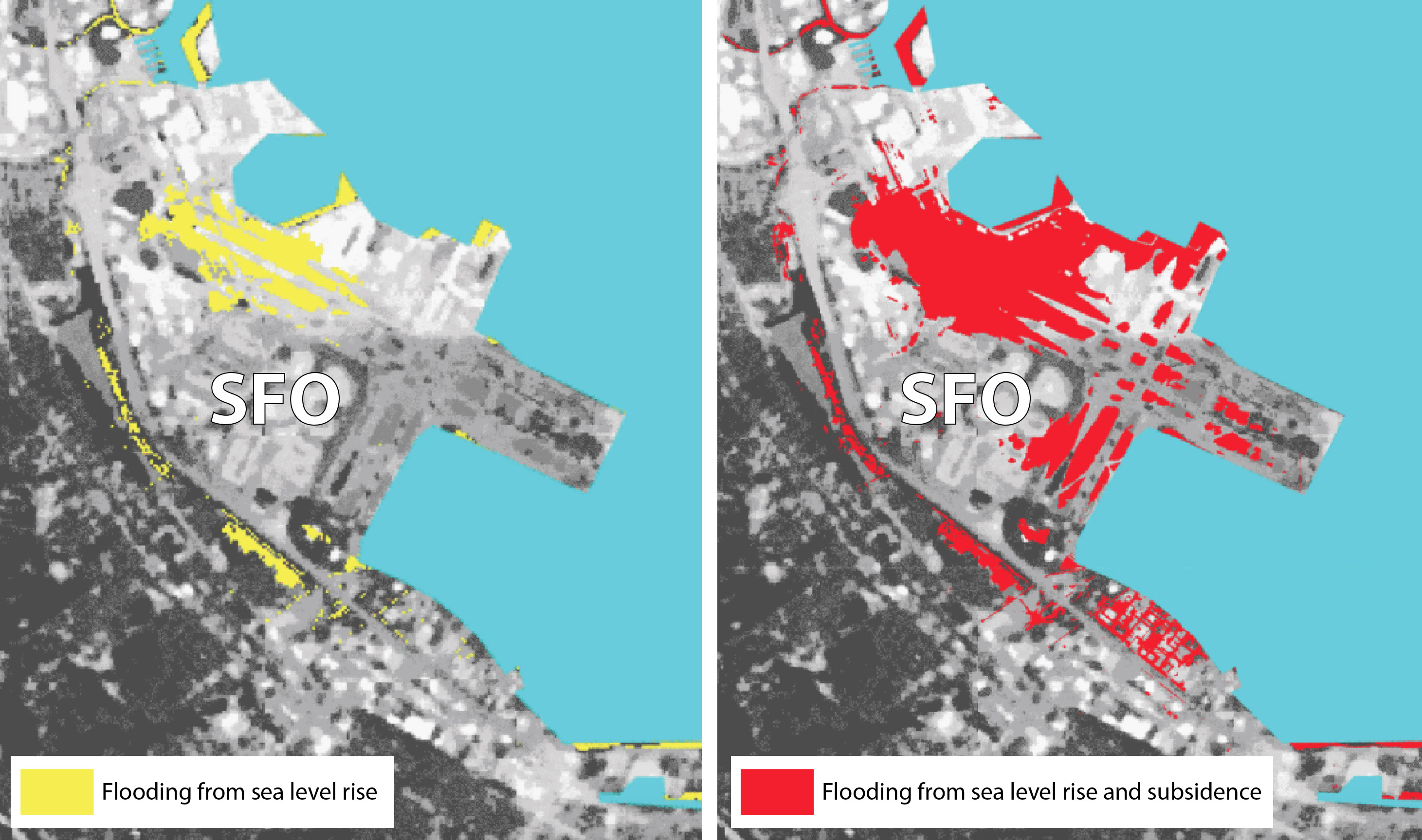
The areas most at risk
In most areas along the Pacific, shoreline subsidence tends to be less than 2 mm/yr. However, parts of San Francisco, San Francisco International Airport, Treasure Island, and Foster City are subsiding as quickly as 10 mm/yr. All of these areas were found to be where there is young Bay mud or artificial deposits that are subject to long-term compaction. To put the rate of subsidence, coupled with sea level rise in eye-opening terms, by 2100, nearly half of San Francisco International Airport will be flooded.

Future outlook
What this information highlights is how incorporating additional factors such as local land subsidence into future flood risk maps can significantly increase exposure. Just for the Bay Area, scientists estimate that by 2100, 480,000 people and more than $100 billion in property will be exposed to flooding from sea level rise alone. This means that an even greater population and more property will actually be at risk. In addition to flooded land, coastal inundation also has additional impacts such as saltwater contamination of water supplies, coastal erosion, and wetland loss. Therefore, the authors state that maps such as these, which are transferable to other areas, will be vital for decision-makers, who will have to improve flood resilience plans to combat the threat of climate change.
References
Manoochehr Shirzaei and Roland Bürgmann, Global climate change and local land subsidence exacerbate inundation risk to the San Francisco Bay Area, Sci. Adv. 2018;4: eaap9234
Sinking land will exacerbate flooding from sea level rise in Bay Area, Robert Sanders, UC Berkeley Media relations
- Beware quiet segments of the Philippine Fault - May 16, 2025
-
ډیری عوامل افغاني ټولنې د زلزلې پر وړاندې زیانمنوي
- August 11, 2022 - What’s happening this week in Humboldt County, California: The squeeze - February 6, 2019