By David Jacobson, Temblor
Check your hazard rank in Temblor
Most people know that San Francisco’s coastline has been altered through the years by periodically filling in various parts of the Bay. However, fewer people know that much of the Financial District is literally built on top of old ships.
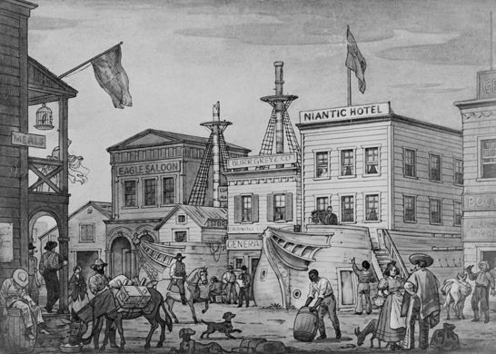
The story behind this goes back to 1848 when gold was discovered at Sutter’s Mill. In the coming years, people swarmed to San Francisco in search of fortune. In Yerba Buena Cove, which is now the heart of San Francisco’s Financial District, over 500 ships were at the docks. Many of these were left abandoned as people headed inland to get rich.

As a consequence, many ships rotted and sank, while others were converted into warehouses, stores and hotels to accommodate the influx of people. Over time however, the ships collapsed and as the cove was filled in, ships were entombed in mud.
Fast-forward about 160 years, and many of the ship locations are where the high-rise buildings of the Financial District are. So, where exactly are these ships? Fortunately, the exact or approximate locations of up to 60 ships scattered throughout San Francisco has been mapped. Below, you can see a Temblor map with ship locations marked, as well as the ancient shoreline.

From the maps above, what immediately becomes startling is how much of San Francisco used to be part of the Bay. This highlights a problem associated with much of San Francisco, liquefaction. It’s important to point out that nearly all areas that used to be part of San Francisco Bay, now have a very high liquefaction susceptibility. This puts the entire area at risk in the event of an earthquake.
Liquefaction has been covered several times on Temblor, most recently when we wrote about the sinking Millennium Tower, also known as the Leaning Tower of San Francisco. To no surprise, the Millennium Tower sits right in the middle of where Yerba Buena Cove used to be. To read more about the science behind liquefaction, CLICK HERE.
While the hazard for much of San Francisco is significant, the point of this blog post is to highlight San Francisco’s history. It’s entirely possible that if you work in the Financial District, there was once an old gold rush ship beneath your building.
[advanced_iframe securitykey=”747e3859478d6f25e27ad6d36a7956d62eb68b4a” src=”http://lead-form.temblor.net” width=”100%” height=”645″]
Sources:
SFGate
FoundSF
SF Genealogy
Atlas Obscura
artwanted.com
Liquefaction and the leaning tower of San Francisco

- Beware quiet segments of the Philippine Fault - May 16, 2025
-
ډیری عوامل افغاني ټولنې د زلزلې پر وړاندې زیانمنوي
- August 11, 2022 - What’s happening this week in Humboldt County, California: The squeeze - February 6, 2019