By David Jacobson, Temblor

At 9:42 p.m. local time last night (16 May 2017), a M=4.1 earthquake struck offshore of Santa Barbara, California. The quake occurred at a depth of 2.3 km, and on the USGS website, over 1,400 people reported feeling the event. Having said that, Santa Barbara, 28 km from the epicenter, is home to nearly 100,000 people, and was exposed to weak shaking, so it is likely that many more people felt the earthquake. So far, there have been five recorded aftershocks to the north of the mainshock, ranging in size from M=1.8 to M=3.1. None of the earthquakes within the last nine hours was large enough to result in any damage, as only moderate shaking was experienced close to the epicenter of the M=4.1.
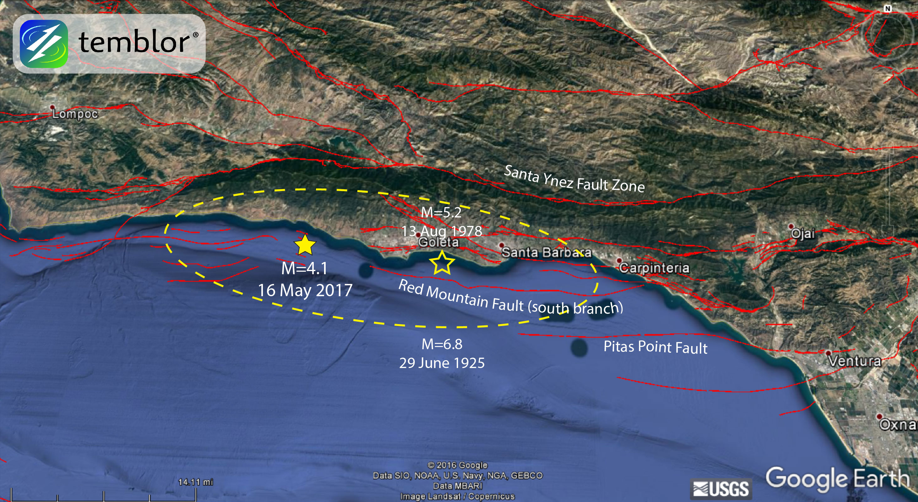
Based on the USGS focal mechanism, this was a purely compressional event with no component of strike-slip motion. While when most people think of faulting in California, they think of strike-slip movement, as is the case for the San Andreas and Hayward faults, in this part of the state, compression dominates, uplifting the Santa Ynez Mountains and the rest of the Transverse Ranges. The fault on which yesterday’s earthquake occurred was relatively steep (50-56°) and located approximately 3.5 km offshore. In this part of California, there are several small unnamed faults which are not believed to have been very seismically active in the last 700,000 years.
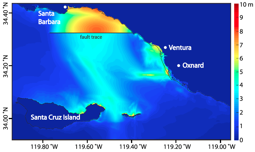
However, just to the east of last night’s quake is the south branch of the Red Mountain Fault Zone, a north-dipping thrust fault. While yearly slip along the Red Mountain Fault is low, 0.4-1.4 mm/yr, the Southern California Earthquake Data Center (SCEDC) believes that by itself, the fault is capable of M=6.0-6.8 earthquakes. Furthermore, some scientists believe that if the Red Mountain and Pitas Point Fault to the southeast were to rupture simultaneously, a M=7.7 earthquake could result, which could generate a locally-sourced tsunami, sending waves up to 30 feet high towards Santa Barbara (See figure below) (Ryan et al., 2015). Such events would cause significant damage to the region. This project was undertaken in 2012 to investigate the earthquake and tsunami hazards in Ventura Country, and as Southern California Earthquake Center scientist David Oglesby said, “we all need to recognize that earthquake hazard doesn’t end at the water’s edge.”
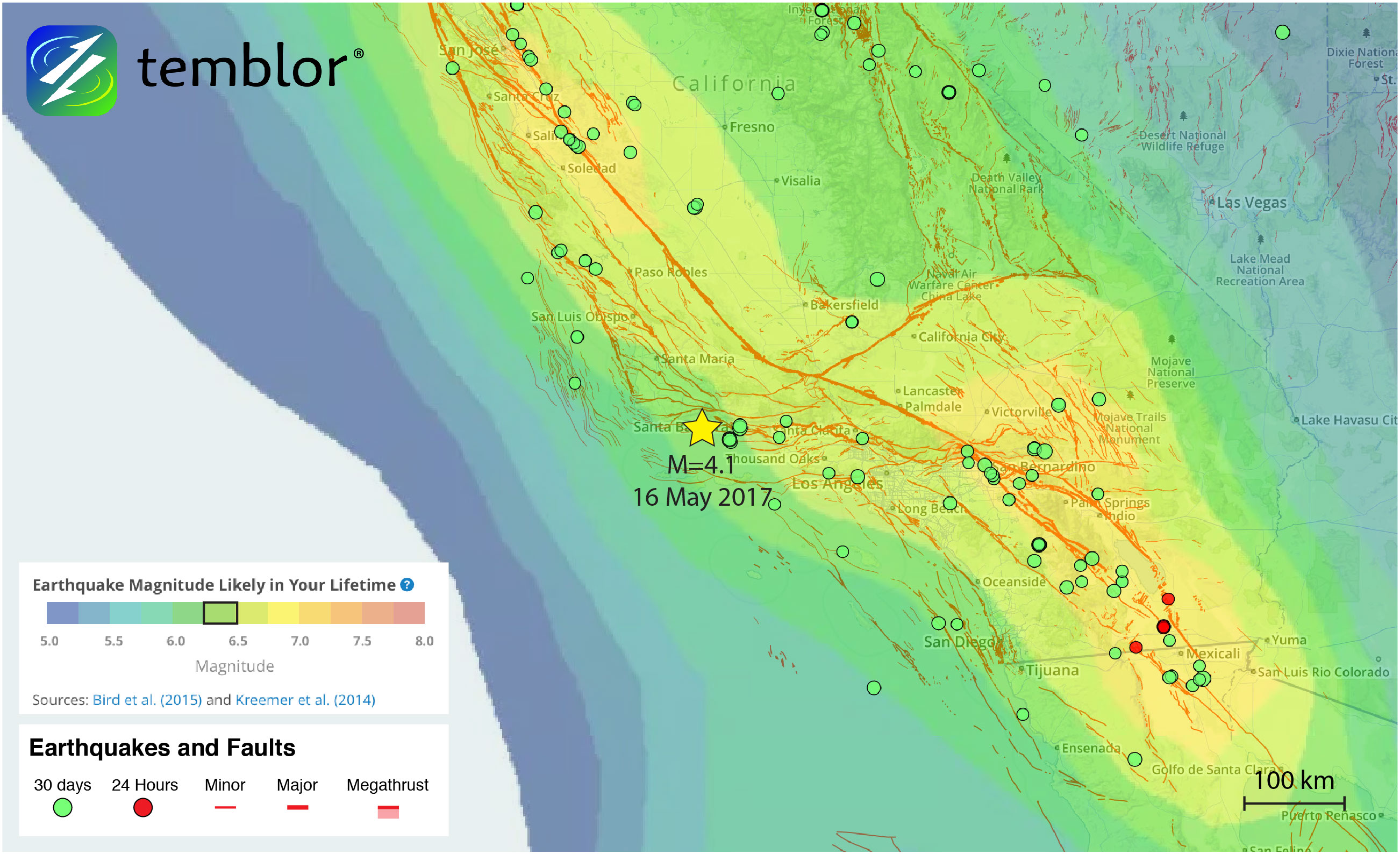
While the probability of a M=7.7 earthquake is likely very low, this part of Southern California is susceptible to moderately large quakes. By using the Global Earthquake Activity Rate (GEAR) model, we can determine what magnitude is most likely. This model, which is available in Temblor, uses global strain rates and seismicity since 1977 to determine the likely earthquake magnitude in your lifetime anywhere on earth. From the figure below, you can see that a M=6.25+ quake is likely to occur around Santa Barbara in your lifetime. The largest recorded quake in the area was a M=6.8 in 1925. It should be pointed out that through correspondence with Dr. Chen Ji (University of California Santa Barbara) and Dr. Lucy Jones (Dr. Lucy Jones Center for Science and Society) it was learned that the 1925 earthquake’s exact location and magnitude is uncertain (Our figure shows the USGS location). Richter analysis comparing it to the 1933 M=6.4 Long Beach earthquake suggests the 1925 quake was a M=6.3. Additionally, some people put its location closer to Santa Barbara. What we do know it that shaking was severe in Santa Barbara and the city was hit hard. Nonetheless, what is important is that large earthquake have occurred in this region historically, and while yesterday’s quake was by no means significant, it allows us to highlight local earthquake hazards in Southern California.
References
USGS
USGS Scientific Investigations Map 3281 – Sheet 8 of 11
Southern California Earthquake Data Center (SCEDC)
Southern California Earthquake Center (SCEC) article titled “Uncovering Tsunamigenic Earthquakes Affecting Southern California” by Jason Ballmann – Link
Ryan, K. J., E. L. Geist, M. Barall, and D. D. Oglesby (2015), Dynamic models of an earthquake and tsunami offshore Ventura, California, Geophys. Res. Lett., 42, 6599–6606, doi:10.1002/2015GL064507.
Correspondence with Dr. Chen Ji (University of California Santa Barbara)
Correspondence with Dr. Lucy Jones (Dr. Lucy Jones Center for Science and Society)
- Beware quiet segments of the Philippine Fault - May 16, 2025
-
ډیری عوامل افغاني ټولنې د زلزلې پر وړاندې زیانمنوي
- August 11, 2022 - What’s happening this week in Humboldt County, California: The squeeze - February 6, 2019