By David Jacobson and Ross Stein, Ph.D, Temblor
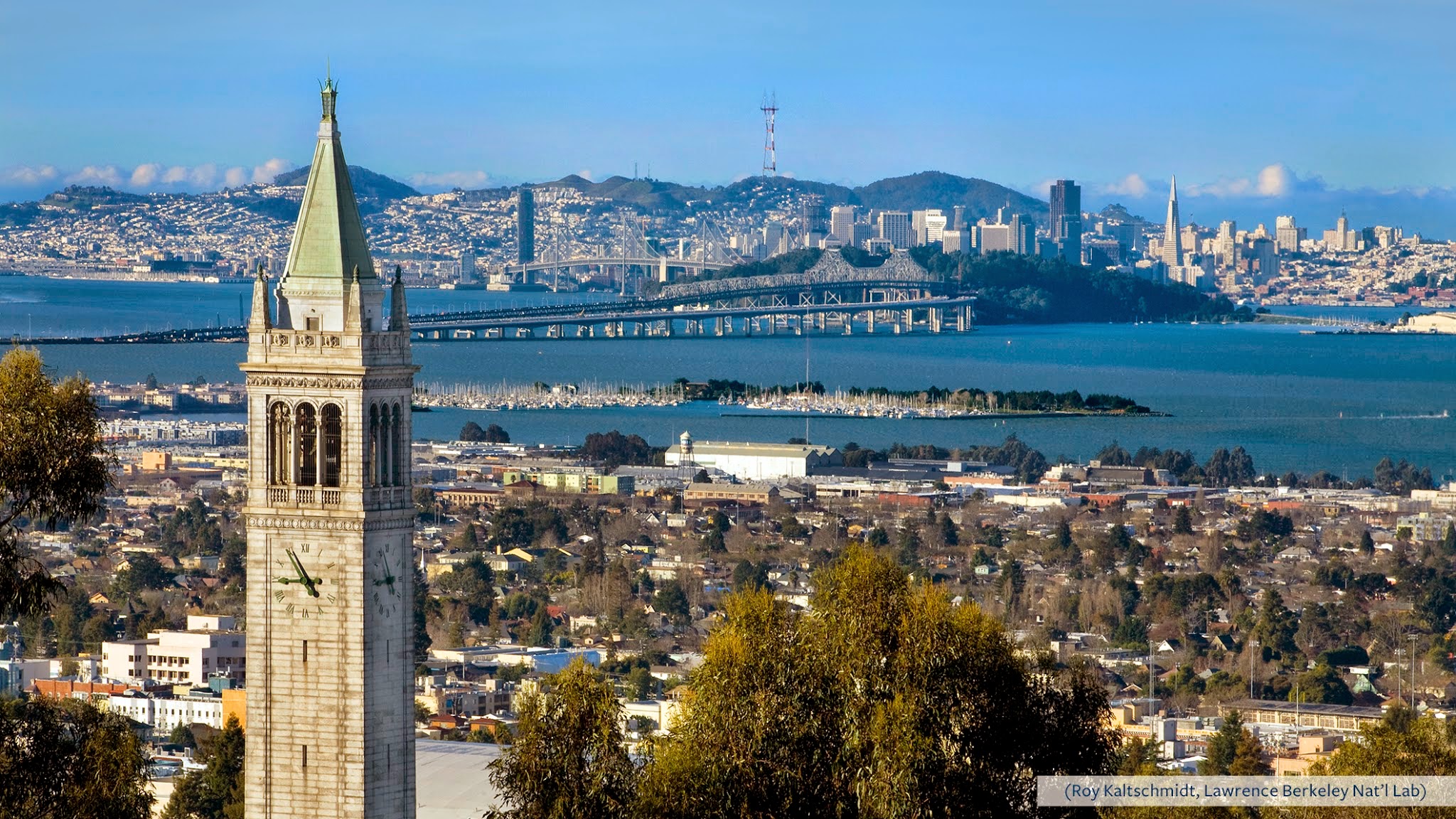
The entire Bay Area was awakened
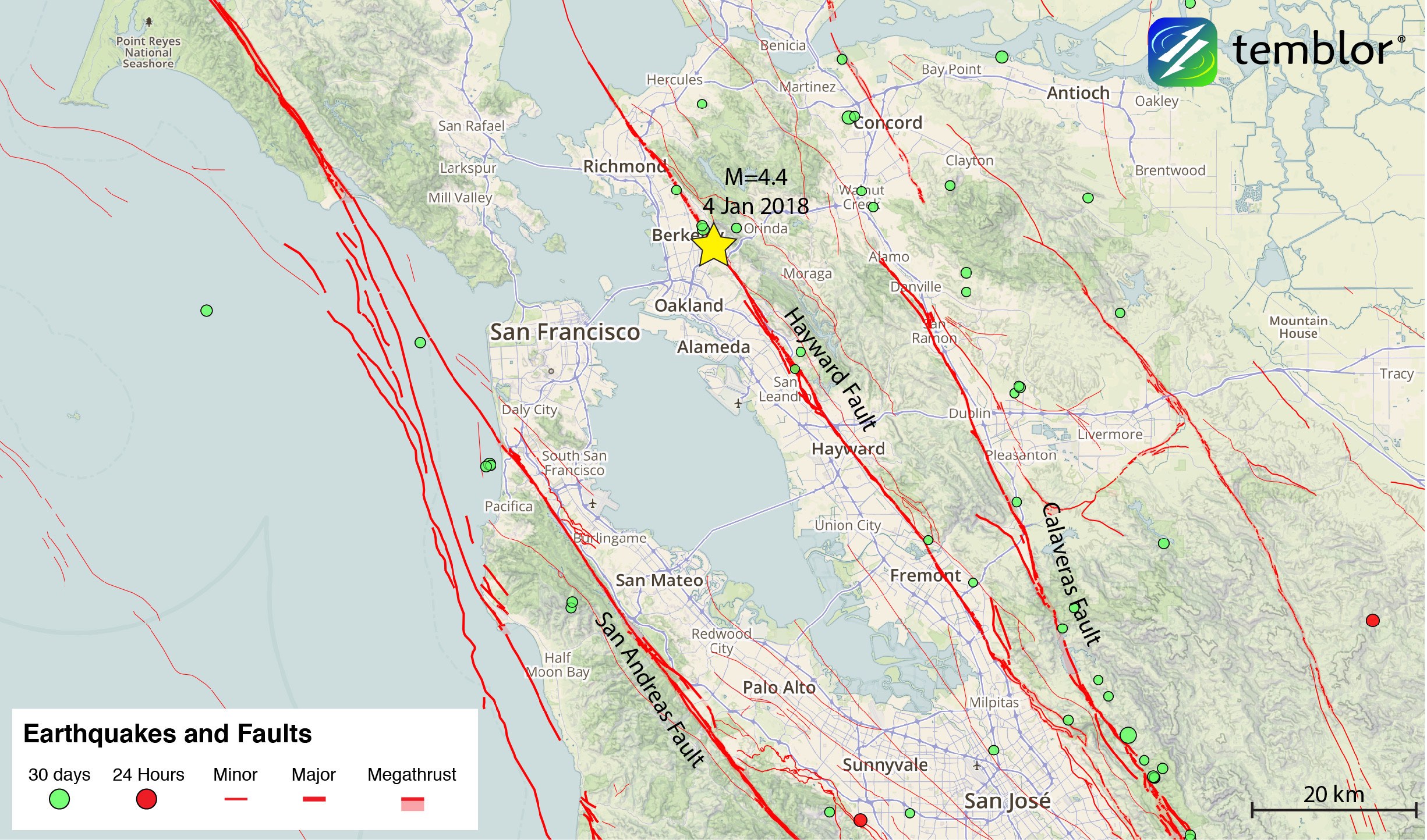
Last night, at 2:39 a.m. local time, a M=4.4 earthquake struck along the Hayward Fault underneath the city of Berkeley. The quake was felt throughout the entire Bay Area, and by noon today, over 35,000 people had filled out felt reports on the USGS website. Based on the distribution of shaking, nearly 10 million people would have been exposed to some level of shaking. Close to the epicenter shaking was moderate, and no damage is expected. Based on its magnitude, the quake was felt across a much greater area than expected.
The last M=4.4 shock on or close to the Hayward Fault struck near Fremont in 1981, some 36 years ago. A M=4.5 shock struck on the Rodgers Creek Fault in 2006 near Santa Rosa. The Rodgers Creek Fault is effectively the same Fault with a different name.
The Hayward Fault—149 years and counting since the last large event
Based on the location, depth (13 km or 8 mi), and mechanism (right-lateral strike-slip), this earthquake very likely occurred on the Hayward Fault itself, and not a secondary strand. The Hayward Fault extends from San Pablo Bay where it joins up with the Rodgers Creek Fault, to south of San Jose, where it merges with the Calaveras Fault, a length of 140 mi (230 km). It makes up one of the larger faults within the San Andreas Fault System, and has a history of large, damaging earthquakes. In 1868, a M~6.8 earthquake destroyed downtown Hayward, and did significant damage in San Francisco. In fact, the 1868 earthquake was known as the “Great Earthquake” until 1906.

The Hayward Fault creeps, as does a 100-mi (170-km) long section of the San Andreas, and only a handful of other California faults. This means that the Hayward Fault is not frictionally locked and can slip without large earthquakes. While some creeping faults are completely unlocked and do not build up the significant stress needed to generate large earthquakes, the Hayward Fault is only partially locked. So while there is creep at the ground surface, large (M~7) earthquakes tend to occur on average every 161±65 years. For those keeping track, it has been 149 years since the last major event.

Today’s quake struck on the edge of a large stuck patch of the Hayward Fault
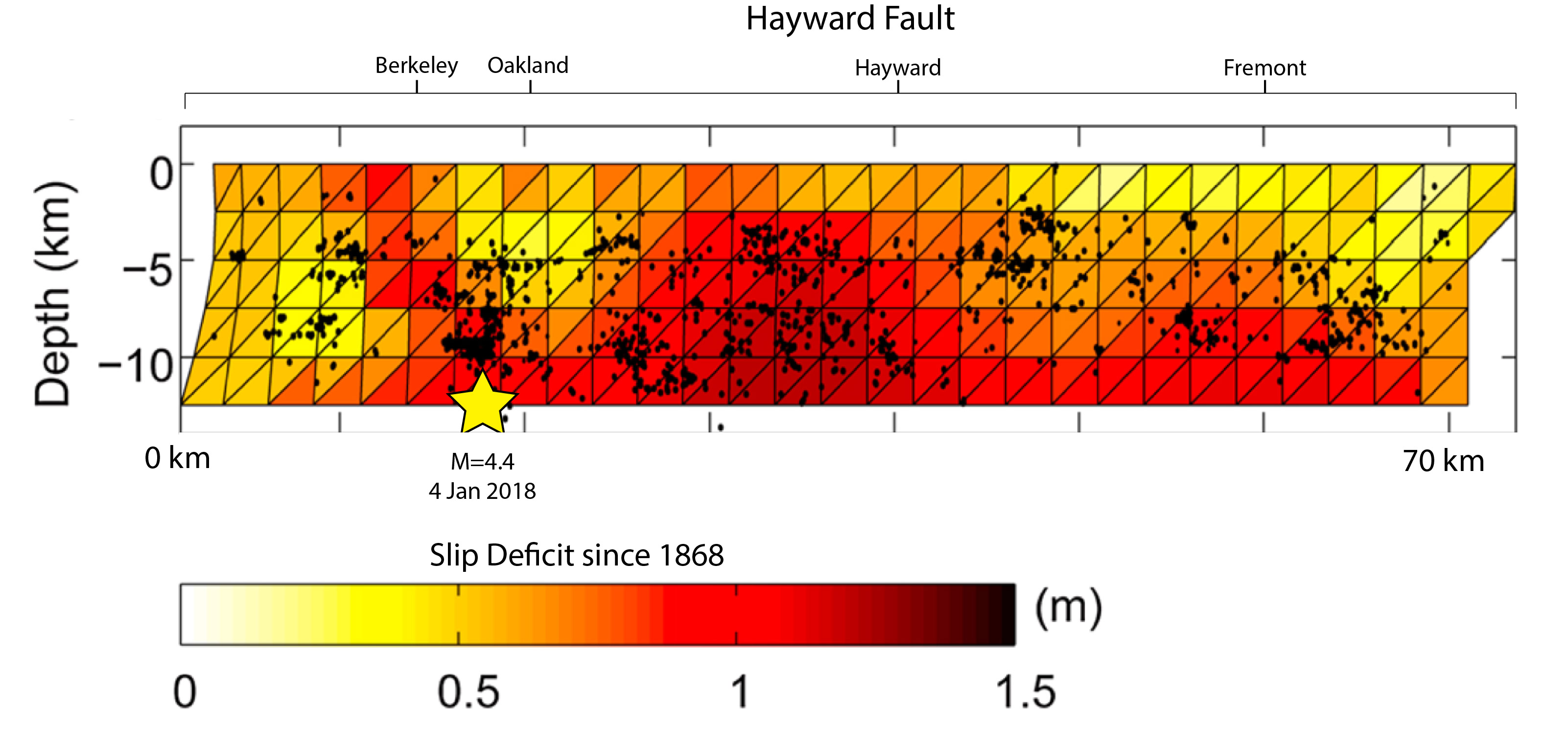
In the area around this morning’s earthquake, there is significant evidence of creep. The figure below, from Shirzaei and Burgmann, 2013, shows creep along the Hayward Fault, with the approximate location of today’s earthquake shown. What becomes evident from this figure is that the area in which this morning’s earthquake nucleated is a locked portion of the fault, and that locked patch extends for 20-30 km (12-20 mi) to the southeast.
Prof. Manoochehr Shirzaei at Arizona State University told Temblor that today’s event “occurred in an area that is stressed due to creep on the surrounding segments, and so was encouraged.” USGS geologist David Schwartz added that, “the M=4.4 occurred along a ‘hotspot’ on the Hayward fault. This is an approximately 8 km (5 mi) long section of the fault that has hosted 15 M 3.0-4.0 shocks in the past 10 years. [Today’s earthquake is] the largest and deepest event in this grouping but its location not unusual.” Because of all of this, this earthquake should not be considered surprising.

What next?
Based on the lack of creep in the location of today’s event, as well as the large locked patch to the south toward Fremont and Hayward, if a large earthquake were to start here, we believe it would rupture to the south. This area also has a slip deficit of more than a meter (3.3 ft) since 1868, as shown in the figure below, suggesting it could be more susceptible to a large earthquake.
Nevertheless, the statistical likelihood of this morning’s earthquake being a foreshock to a M=6+ event in the next week is low, about 1 chance in 250, according to the USGS. However, the USGS does also estimate that there is a 10% chance that this could be a foreshock to an earthquake of equal or greater magnitude. Therefore, people should renew and reconsider their seismic readiness.
One of the reasons why the Hayward Fault is of great importance is because James Lienkaemper and Patrick Williams, 2010 calculated from the record they unearthed of prehistoric earthquakes that there is a 29% chance of a large quake along this portion of the Hayward Fault in the next 30 years. The USGS has multiple earthquake scenarios for this section of fault, some of which reach M=7.4. Such an event would have a significant impact on the entire Bay Area, stressing the importance of preparation. The USGS is developing a scenario of such an event (HayWired)
We are behaving like cigarette smokers
David Oppenheimer, the former director of the USGS Northern California Seismic Network, had this to say to Temblor: “The scientific and engineering communities have led us to the solution to seismic resilience, but the public behaves like a cigarette smoker. They know that quakes are bad for them, but they are not willing to do what they should.”
He continues, “The solution is to follow the leads of San Francisco, Santa Monica and Los Angeles that require substandard residential structures to be identified and seismically retrofit in a timely fashion. Unfortunately, none of these programs apply to homes; they only address apartment and larger buildings. Mortgage lenders should require property owners to carry earthquake insurance. Elected officials must do their part to implement ordinances and laws that require the public to upgrade at-risk private property. A small investment in mitigation will have large payoffs to property owners, inhabitants, and resiliency of our metropolitan area.”
References
Manoochehr Shirzaei, Roland Bürgmann, Taka’aki Taira (2013), Implications of recent asperity failures and aseismic creep for time-dependent earthquake hazard on the Hayward fault, Earth and Planetary Science Letters 371–372 (2013) 59–66, doi.org/10.1016/j.epsl.2013.04.024
Shirzaei, M., and R. Burgmann (2013), Time-dependent model of creep on the Hayward fault from joint
inversion of 18 years of InSAR and surface creep data, J. Geophys. Res. Solid Earth, 118, doi:10.1002/jgrb.50149.
James J. Lienkaemper, Patrick L. Williams, and Thomas P. Guilderson, Evidence for a Twelfth Large Earthquake on the Southern Hayward Fault in the Past 1900 Years, Bulletin of the Seismological Society of America, Vol. 100, No. 5A, pp. 2024–2034, October 2010, doi: 10.1785/0120090129
Detweiler, S.T., and Wein, A.M., eds., 2017, The HayWired earthquake scenario—Earthquake hazards: U.S. GeologicalSurvey Scientific Investigations Report 2017–5013–A–H, 126 p., https://doi.org/10.3133/sir20175013v1.
Berkeley Seismology Lab – Link
USGS – Event page
Felix Waldhauser’s Lamont-Doherty Earth Observatory double-difference real-time earthquake catalog –
Event page
- Beware quiet segments of the Philippine Fault - May 16, 2025
-
ډیری عوامل افغاني ټولنې د زلزلې پر وړاندې زیانمنوي
- August 11, 2022 - What’s happening this week in Humboldt County, California: The squeeze - February 6, 2019