By David Jacobson, Temblor

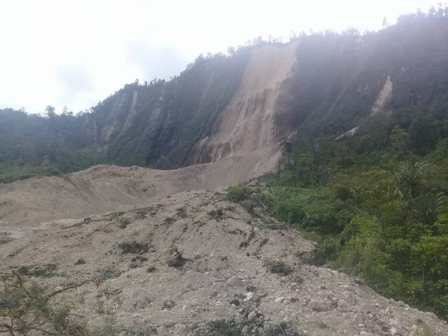
In just the last day, a series of large magnitude earthquakes has struck the nation of Papua New Guinea. The series started with a M=7.5 at 3:44 a.m. local time, and in the last 24 hours, there have been 43 M=4.5+ aftershocks, including a M=6.3 approximately four hours ago. According to the USGS, the mainshock struck at a depth of 35 km, and was primarily compressional in nature, leading to violent shaking near the epicenter. While few reports of damage have come in because much of the region had communications knocked out, the Papua New Guinea Post Courier reports that the provincial administrator, William Bando, said that at least 10 people were killed, and that thousands of properties were destroyed. However, the number of fatalities is likely to rise are more information comes in. Additionally, because the region is very mountainous, landslides are of major concern (see photo below).

The island of New Guinea, which Papua New Guinea shares with West Papua, a province of Indonesia, lies near the convergence of the Australian and Pacific plates. At the location of the recent earthquakes, the rate of convergence is approximately 106 mm/yr (4 in/yr). While the boundary between the Australian and Pacific plates is where the majority of seismicity occurs, there are also many smaller microplates in the region, which makes for a complex geologic assemblage. Nonetheless, given the depth, location, and focal mechanisms of the earthquakes in the last day, they likely occurred within the Australian plate.
While Papua New Guinea is no stranger to seismic activity, yesterday’s M=7.5 quake struck in a region not known for its seismicity. In fact, the closest major earthquake was a M=6.2 in 1993 17 km to the north. Instead, the majority of the seismicity in the region is along the plate boundary between the Australian and Pacific plates to the north and east of the recent activity.
By using the Global Earthquake Activity Rate (GEAR) model, which is available in Temblor, we can see if the recent earthquakes should be considered surprising. This model uses global strain rates and the last 40 years of seismicity to estimate the likely earthquake magnitude in your lifetime anywhere on earth. From the figure below, one can see that in the location of yesterday’s M=7.5, the likely earthquake is M=6.5+. While this suggests that the M=7.5 can be considered surprising, given its size, it does highlight the seismic threat posed to the island nation. Should more information come in about this earthquake, we will update this post.

References
USGS
Papua New Guinea Post Courier
- Beware quiet segments of the Philippine Fault - May 16, 2025
-
ډیری عوامل افغاني ټولنې د زلزلې پر وړاندې زیانمنوي
- August 11, 2022 - What’s happening this week in Humboldt County, California: The squeeze - February 6, 2019