By Gabriel Lotto, Temblor
Check your hazard rank in Temblor
Hurricane Matthew is bearing down on Florida, prompting governments to declare states of emergency and forcing millions of residents to evacuate. No hurricane has hit mainland Florida since Wilma in 2005, but Florida Governor Rick Scott has tried to instill an appropriate amount of urgency among Floridians, warning that “This storm will kill you.” If that isn’t scary enough, the National Hurricane Center has published maps of expected storm surge for Florida, Georgia, and South Carolina that predict a significant chance of major coastal flooding.

The Potential Storm Surge Flooding map tries to predict flooding from storm surge along the coast, including tidal rivers, sounds, and bays that connect to the ocean. Since hurricanes are still very difficult for meteorologists to predict, this map takes into account uncertainties in storm path, speed and intensity. It offers a realistic worst-case scenario rather than a guaranteed prediction.
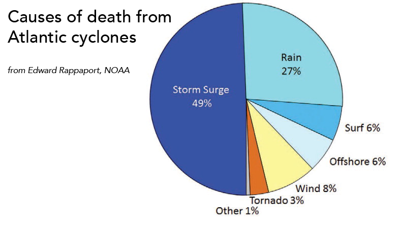
Still, predictive storm surge maps like these are extremely important, because flooding from storm surges has caused almost 50% of all deaths from Atlantic cyclones.
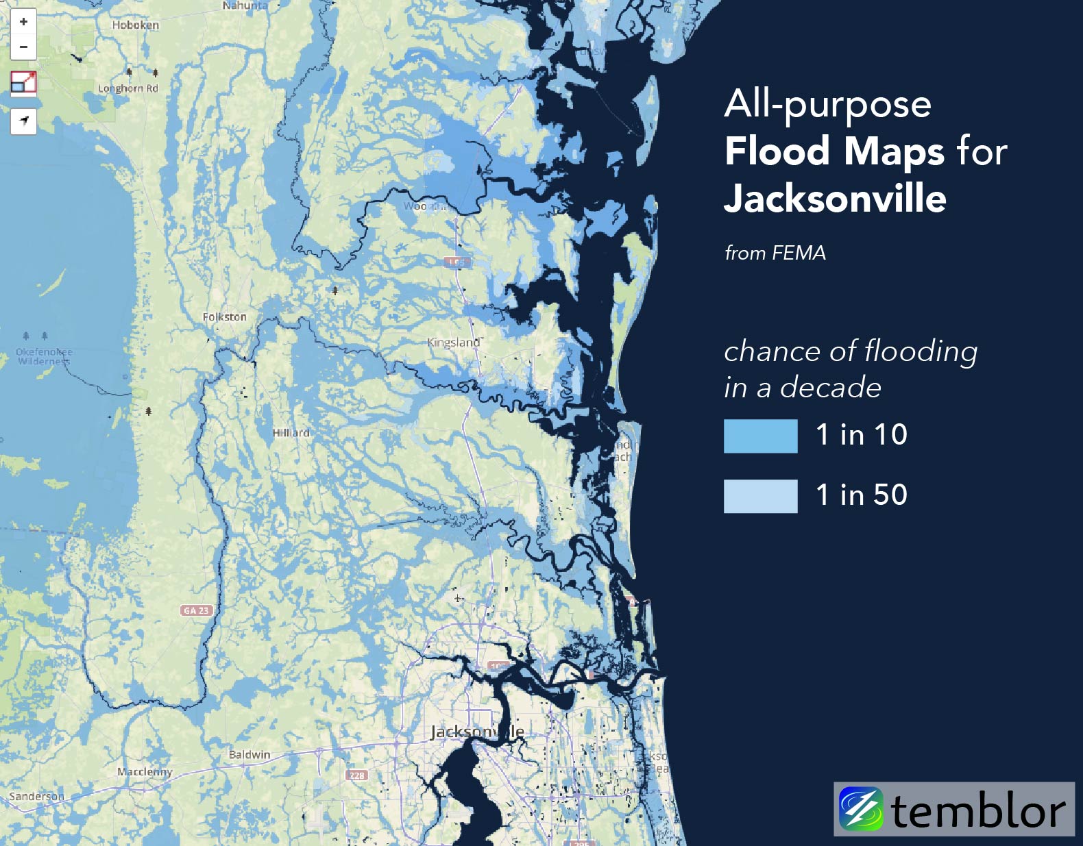
But these storm surge maps don’t include inland flooding caused by rain, which is the second leading cause of death from tropical cyclones in the US. It’s not easy to predict where rapid rainfall will overwhelm lakes and rivers and cause flooding, but FEMA’s flood maps offer some insight.
By supplementing storm surge maps made specifically for Hurricane Matthew with more general flood maps, we can get a sense of where rainfall-induced flooding might occur. Let’s take a closer look at Jacksonville, Florida, a city located directly in the hurricane’s path.
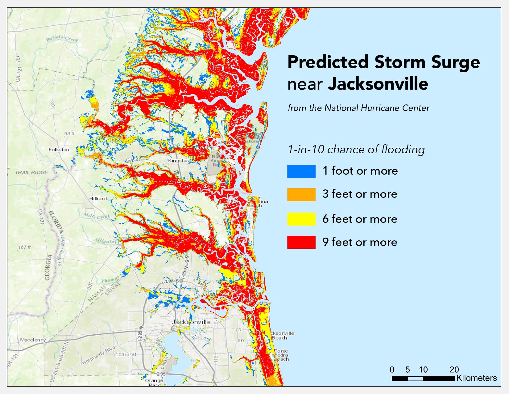
The National Hurricane Center expects the area in and around Jacksonville to see massive storm surges over the next few days. But according to FEMA’s all-purpose flood maps – viewable for the entire US on Temblor – coastal Florida and Georgia are already highly susceptible to flooding. In addition, the FEMA flood map below gives an early indication of where rain is most likely to directly cause flooding, independent of storm surge.
Predicted Storm Surge maps are made available by the National Hurricane Center.
FEMA floods maps for every US state are available on Temblor.
Sources:
Edward N. Rappaport, 2014: Fatalities in the United States from Atlantic Tropical Cyclones: New Data and Interpretation. Bull. Amer. Meteor. Soc., 95, 341–346, doi: 10.1175/BAMS-D-12-00074.1.
National Hurricane Center
FEMA
- Earthquake science illuminates landslide behavior - June 13, 2025
- Destruction and Transformation: Lessons learned from the 2015 Gorkha, Nepal, earthquake - April 25, 2025
- Knock, knock, knocking on your door – the Julian earthquake in southern California issues reminder to be prepared - April 24, 2025