The largest earthquake in Victoria in at least two centuries rattled buildings across Melbourne, but some were damaged more than others.
By Mark Leonard, Ph.D., Leonard Seismic Consulting
Citation: Leonard, M., 2021, What controlled damage patterns during Australia earthquake?, Temblor, http://doi.org/10.32858/temblor.210
A magnitude-5.9 earthquake struck in southeastern Australia on September 22, 2021, at 9:15 am local time. This is the largest earthquake in Victoria in the two centuries of European settlement. Aboriginal Australians have lived in eastern Victoria for around 40,000 years.
The earthquake struck in the Victorian Alps, a remote mountainous area in eastern Victoria. The area has hosted four large earthquakes in the last half a century: the 1968 magnitude-5.4 Mt. Hotham quake, the 1982 magnitude-5.4 Mt. Sarah quake, the 1996 magnitude-5.0 Mt. Baw Baw/Thomson Dam quake and Tuesday’s magnitude-5.9 Woods Point quake.

Shaking felt over a wide area
In the 24 hours following the earthquake, Geoscience Australia received 41,000 felt reports, in which people recounted how much shaking occurred at their location. Of the reports submitted, only 30 respondents were located within 25 miles (40 kilometers) of the epicenter. This is consistent with the sparse population of the area. Reports from within 12 miles (20 kilometers) indicate strong shaking intensity (MMI VI).
The earthquake was felt over much of southeastern Australia: from Adelaide (750 kilometers west) to Sydney (600 kilometers northeast), and even in Brisbane (1200 kilometers north).
Ground motion models (GMMs), which estimate the level of ground shaking observed at a site for a specified magnitude and distance, are used to evaluate earthquake hazard in any given area. The level of local ground shaking depends on factors including the location and depth of the earthquake and ground type.
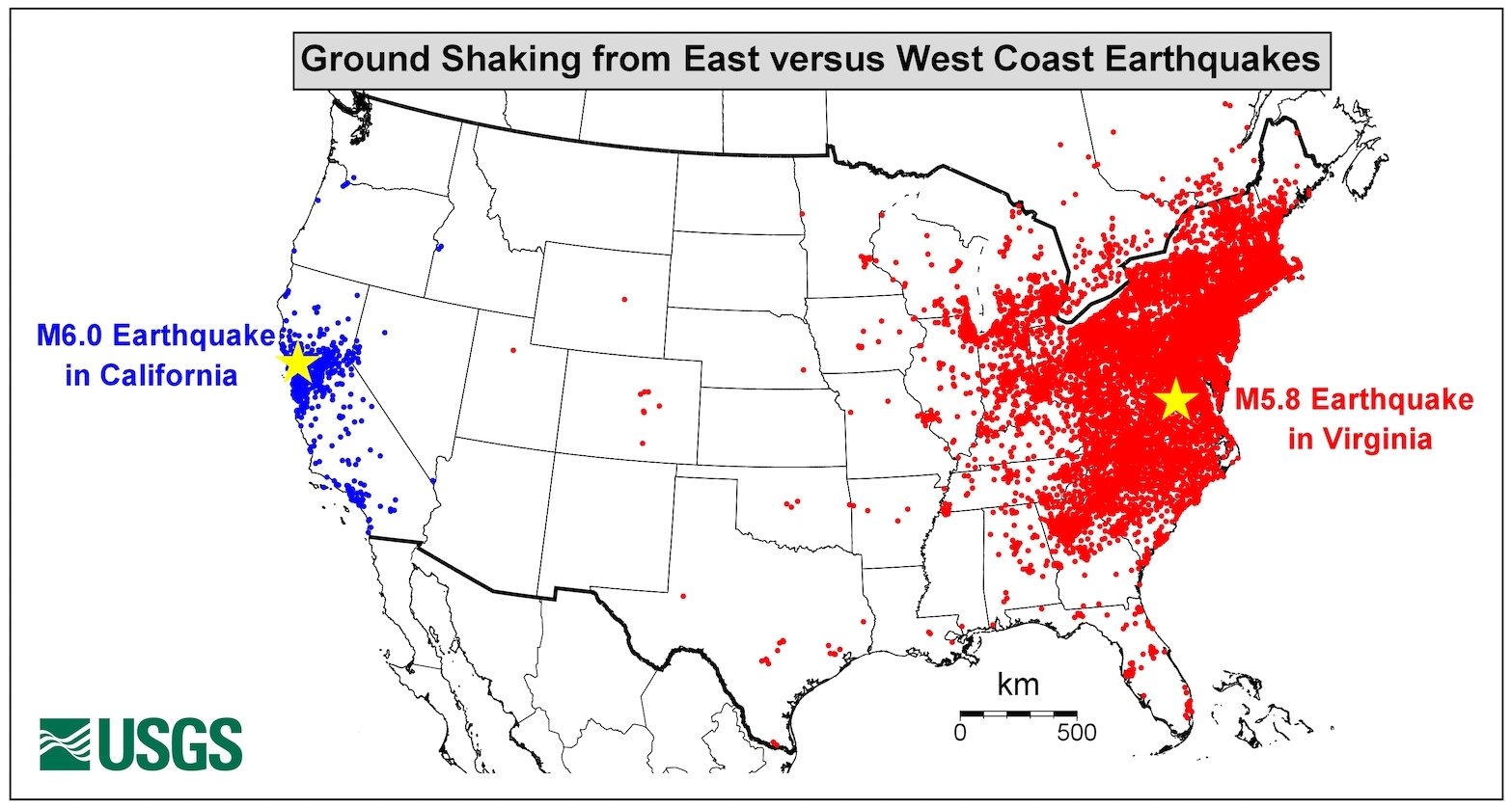
Based on both best fit to the limited strong ground motion data available and geological analogy, for eastern Australia, most seismic hazard modellers use GMMs developed for the western U.S., where shaking occurs over a relatively narrow area compared to the eastern U.S. However, the area over which shaking was felt in the Woods Point earthquake is similar to the felt area of the 2011 magnitude-5.8 Mineral earthquake in Virginia, on the U.S. east coast. This raises the question of whether western U.S. models are the most appropriate for eastern Australia. The strong motion data from this earthquake will be invaluable in developing new models and assessing the best GMM for the region.
Both the Victorian Alps and the Latrobe Valley to the south are amongst the most seismically active areas of Australia. As such the seismic hazard of these regions is relatively high, for both the 2012 and 2018 National Seismic Hazard Maps from Geoscience Australia.
Melbourne rattled, but relatively little damage reported
Melbourne, which has population of five million, is 80 miles (130 kilometers) from the epicenter. The city’s eastern fringe is only about 60 miles (100 kilometers) away. For an earthquake of this magnitude so close to a major city, the impact was relatively small. There were no deaths or serious injuries reported. No serious structural damage occurred.
One of the most affected buildings in Melbourne was on the corner of Green and Chapel Streets in Windsor, where a section of unbraced brick parapet wall that rose at least 10 feet (three meters) above the ceiling of the second story collapsed onto the street below. This style of structure is notoriously prone to earthquake damage.

Initial insurance claim data indicates that at least 1,500 buildings suffered minor damage such as fallen masonry (e.g. chimneys) and cracks to plaster, render and walls.
An explosion in Melbourne’s population from 23,000 in 1850 to 490,000 in 1890 spurred construction of multi-story unreinforced masonry buildings throughout the region. Initial reports suggest these late Victorian two- to three-stories buildings suffered the most serious damage in the Woods Point earthquake. Most of the damage occurred in suburbs three miles (five kilometers) southeast of downtown Melbourne.
Damage related to ground shaking
Building damage from the quake may correlat to the strength of the ground below. Soft soils amplify passing seismic waves, whereas harder rocks do not. When waves are amplified, shaking is more intense.
On the eastern fringe of Melbourne, the ground is mostly made of rock. None of the Victorian unreinforced masonry buildings in this part of the region suffered any damage. However, suburbs such as Prahran and Windsor did experience damage from the quake, despite being 20 miles (30 kilometers) farther from the epicenter. These areas sit on stiff soil, which is softer than rock and would have amplified seismic waves. It is unsurprising that areas where shaking was more intense saw more damage.
Preliminary reports from field crews indicate that no buildings were damaged within 12 miles (20 kilometers) of the epicenter. Even circa 1940 two-story unreinforced masonry buildings just seven miles (12 kilometers) from the epicentre were untouched. Further research is need to determine why these buildings were spared. Detailed assessments of building damage, along with studies of the subsurface, will provide invaluable constraints for future seismic risk assessments Melbourne.
Quake uncertainties
Some details of the location and mechanism of this earthquake remain unresolved. Geoscience Australia, Seismology Research Centre and the USGS estimate the earthquake occurred around seven miles (11 kilometers) below the surface. However Geoscience Australia and USGS also calculated moment tensor fault plane solutions — another means of estimating earthquake depth — that indicate depths of around 11-13 miles (18-21 kilometers). Resolving the depth will be important in understanding the distribution of ground shaking.
Researchers use the magnitude of an earthquake and a scaling relationship to estimate the size of the ruptured fault (Wells and Coppersmith 1994). Using the relation from Leonard (2014), the fault associated with this earthquake is expected to be approximately 5.5 miles (nine kilometers) long and 3.5 miles (5.5 kilometers) wide.
Given how deep the earthquake struck, it is unlikely that the surface was ruptured. The area around the epicenter is rugged and heavily forested. Therefore identifying any surface faulting would be difficult. Satellite-based imaging, which is used to identify subtle surface displacement near faults, unfortunately performs poorly in forested areas. The lack of roads, steep terrain and thick forest cover will make field work a challenge.
References
Clark, D., & Leonard, M. (2003). Principal stress orientations from multiple focal-plane solutions: new insight into the Australian intraplate stress field. Special Papers-Geological Society of America, 91-106.
Leonard, M. (2014). Self‐consistent earthquake fault‐scaling relations: Update and extension to stable continental strike‐slip faults. Bulletin of the Seismological Society of America, 104(6), 2953-2965.
Wells, D. L., & Coppersmith, K. J. (1994). New empirical relationships among magnitude, rupture length, rupture width, rupture area, and surface displacement. Bulletin of the Seismological Society of America, 84(4), 974-1002.
- Venezuela’s doublet leaned toward Caracas - June 30, 2026
- Is Southern California’s Cajon Pass an ‘earthquake gate’ ready to open? - June 29, 2026
- Philippines magnitude 7.8 shock may have loaded the central Cotabato subduction zone - June 11, 2026