Wednesday’s magnitude-7.3 quake, which shook large parts of Honshu and knocked out power to Tokyo, is the latest in a series of large aftershocks from the 2011 Tohoku earthquake.
By Shinji Toda, Ph.D., IRIDeS, Tohoku University, and Ross S. Stein, Ph.D., Temblor, Inc.
Citation: Toda, S., Stein, R., 2022, ‘Triplet’ earthquakes strike near Tohoku, Japan, but a rupture gap remains, Temblor, http://doi.org/10.32858/temblor.246
This article is also available in Japanese.
On Wednesday, March 16, 2022, a magnitude-7.3 shock struck 40 kilometers (25 miles) off the Tohoku Prefecture coast, causing strong shaking and damage to infrastructure and buildings. Three people were killed and 180 injured. Strong shaking reached Sendai and the Tohoku coastal cities, and power was knocked out for roughly 12 hours across Kanto, 330 kilometers (200 miles) away. A Tohoku Shinkansen bullet train with about 80 passengers on board derailed, fortunately with no loss of life.
This quake is just one of a series of large shocks to strike the Honshu coast in the last decade. These events are signs that Earth’s crust is readjusting itself after the magnitude-9.0 Great Tohoku earthquake in 2011.
Twin quakes rupture
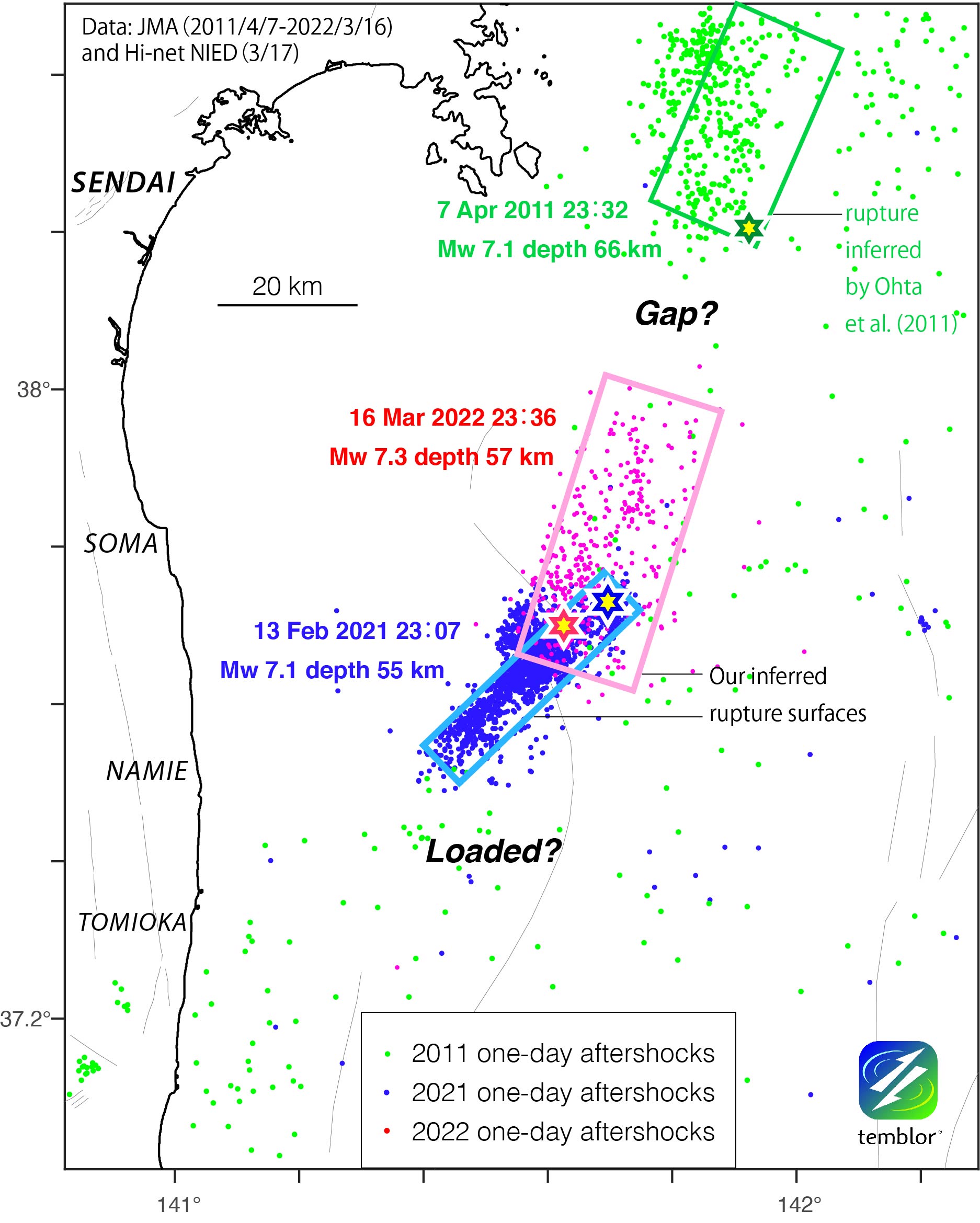
Wednesday’s quake struck just 7 kilometers (12 miles) southwest of a magnitude-7.1 that struck a year before, on February 12, 2021. The 2021 event ruptured mostly southward, along a 45-kilometer (27-mile) section of fault within the subducting Pacific tectonic plate. Wednesday’s event ruptured at a similar depth, but propagated to the north. The ruptured patches of these two quakes partially overlap. Wednesday’s earthquake essentially doubled the length of fault that ruptured in 2021 (the combined extent of blue and magenta shocks in figure below). Earthquakes that strike near one another in space and time — so called “twin” or “doublet” earthquakes — are surprisingly common worldwide (Kagan and Jackson, 1999). They likely occur when faults re-rupture after a previous quake failed to relieve all the accumulated stress.
Earthquakes in the subducting Pacific plate
Both the 2021 and 2022 earthquakes occurred along faults within the Pacific plate, where it descends beneath the main Japanese island of Honshu. These faults are either tears that formed as the Pacific plate is bent downwards, or old faults in the ocean crust that are reactivated as the plate is compressed during subduction. Earthquakes that strike along these faults are called ‘intra-slab’ events and they occur in subduction zones around the world. Events can be as large as magnitude-8.0. Although they often are not as devastating as the largest megathrust earthquakes, they can cause tsunamis and widespread damage.
In contrast, the 2011 magnitude-9.1 Tohoku event was a “megathrust” earthquake, which struck 120 kilometers (70 miles) to the northeast of Wednesday’s epicenter. During the 2011 event, the Pacific plate slid under Honshu about 30 meters (100 feet) in the span of 200 seconds.

Triplets leave a rupture gap
But there’s more to the story, because a month after the 2011 Tohoku earthquake, a magnitude-7.1 intra-slab earthquake struck, 60 kilometers (36 miles) north of Wednesday’s epicenter (Ohta et al, 2011). That event ruptured a 30-km tear in the Pacific plate. The southern end of that rupture ends about 30 kilometers (20 miles) north of the ruptured area of Wednesday’s quake. Between these sections that has not ruptured in a major way in recent history.
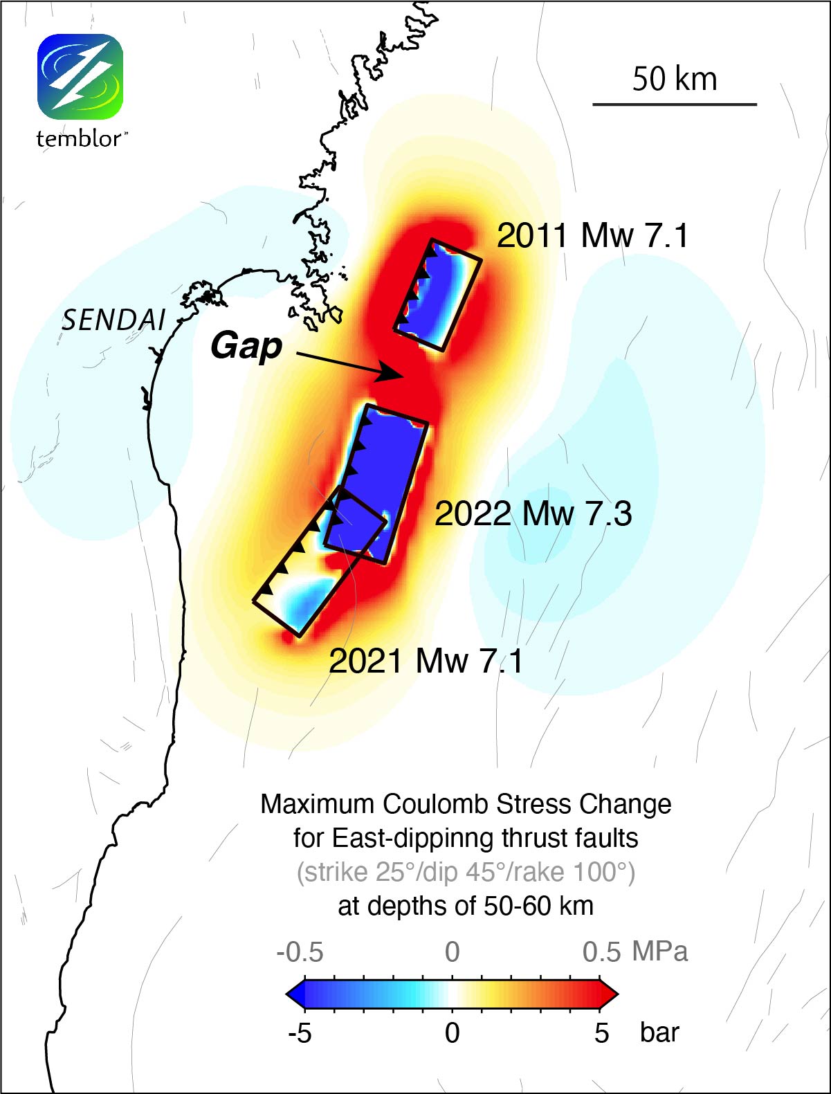
Earthquakes are promoted when a nearby shock deforms the surrounding crust in such a matter as to either unclamp a fault, or increases its shear stress; this is called the Coulomb hypothesis. When we calculate the areas in which stress increased following these three recent earthquakes, the gap lights up in red: It has been brought significantly closer to failure, and so is a likely candidate for a future earthquake in this sequence. But there are also other areas, such as to the north of the 2011 M 7.1 shock, where failure is also promoted.
But we know that faults are not simple, parallel surfaces as assumed in the figure above. Where we have the best data and field evidence, faults have a diversity of lengths and orientations on many scales, and are even sometimes described as a fractal distribution. So, how can we capture this natural complexity in our forecast models? We do so by using past shocks, even tiny ones, to tell us where faults are, and how they are oriented.
We show a messier — but we believe more accurate — picture of the stress imparted on faults by the three intra-slab earthquakes in the figure below. We represent the orientation of faults on which past earthquakes have occurred by beachballs. Red beachballs indicate faults were brought closer to failure — the point at which an earthquake occurs. Blue beachballs indicate faults inhibited from failure (Toda and Stein, 2021). A group of red beachballs to the north of Wednesday’s event is apparent, reinforcing our view that this gap is the most likely candidate for the next shock in the sequence, should it continue. But there is plenty of red to the southeast of the 2021 and 2022 ruptures as well. Fortunately, if an earthquake were to strike in the areas southeast of the recent ruptures, shaking in coastal communities would be less than if a quake closer.

Shaking reproducibility
The three recent intra-slab shocks, each about 50 kilometers (30 miles) offshore and about 60 kilometers (35 miles) deep, provide a rare natural experiment on the reproducibility of strong shaking from one quake to the next. The Japan Meteorological Agency (JMA) operates a dense network of shaking intensity sensors throughout the country. The intensity records of the three events, shown below, are remarkably consistent, with a similar distribution of shaking and roughly the same number of peak shaking records (JMA Intensity 6+, which corresponds to a peak ground acceleration of about 0.5 g, the level at which major damage is expected). This means that we can forecast the shaking with some confidence. Of course, had these shocks been shallower or closer to the coast, the shaking and damage would have been much higher.
But there is a catch. The intensity meters measure the peak shaking, not how long it lasts. The shaking intensities recorded by the 2011 magnitude-9.1 Tohoku earthquake are greater than for the 2021-2022 shocks, but only by about 15-50%, even though the magnitude-9.1 was almost 1,000 times larger than the recent event. The difference lies in the duration of strong shaking, which lasted for about three minutes in the Tohoku quake, and just 15 seconds for the magnitude-7 shocks. Bend a paper clip once, and it will be fine. Bend it back and forth ten times, and it breaks: long durations cause buildings to fatigue.

Why the flurry of shocks?
Although it seems remarkable that the Tohoku coastal region has been hit by three large shocks since the 2011 quake, in our view, they are all aftershocks of the Tohoku earthquake (we show evidence for this in Toda and Stein, 2021). In our judgment, more quakes are likely, albeit at a decreasing rate, for decades.
References
Y. Y. Kagan and D. D. Jackson (1999), Worldwide doublets of large shallow earthquakes, Bull. Seismol. Soc. Amer., 89, 1147-1155.
Yusaku Ohta, Satoshi Miura, Mako Ohzono, Saeko Kita, Takeshi Iinuma, Tomotsugu Demachi, Kenji Tachibana, Takashi Nakayama, Satoshi Hirahara, Syuichi Suzuki, Toshiya Sato, Naoki Uchida, Akira Hasegawa, and Norihito Umino (2011), Large intraslab earthquake (2011 April 7, M 7.1) after the 2011 off the Pacific coast of Tohoku Earthquake (M 9.0): Coseismic fault model based on the dense GPS network data, Earth Planets Space, 63, 1207–1211.
Toda, S., Stein, R.S. (2021), Recent large Japan quakes are aftershocks of the 2011 Tohoku Earthquake, Temblor, http://doi.org/10.32858/temblor.175
- Venezuela’s doublet leaned toward Caracas - June 30, 2026
- Is Southern California’s Cajon Pass an ‘earthquake gate’ ready to open? - June 29, 2026
- Philippines magnitude 7.8 shock may have loaded the central Cotabato subduction zone - June 11, 2026